| | 1 — | [Church of the Dormition, Kenai, 1973] |
| | 2 — | [two buildings in old town Kenai, Church of the Dormition at right; print date Apr 73] |
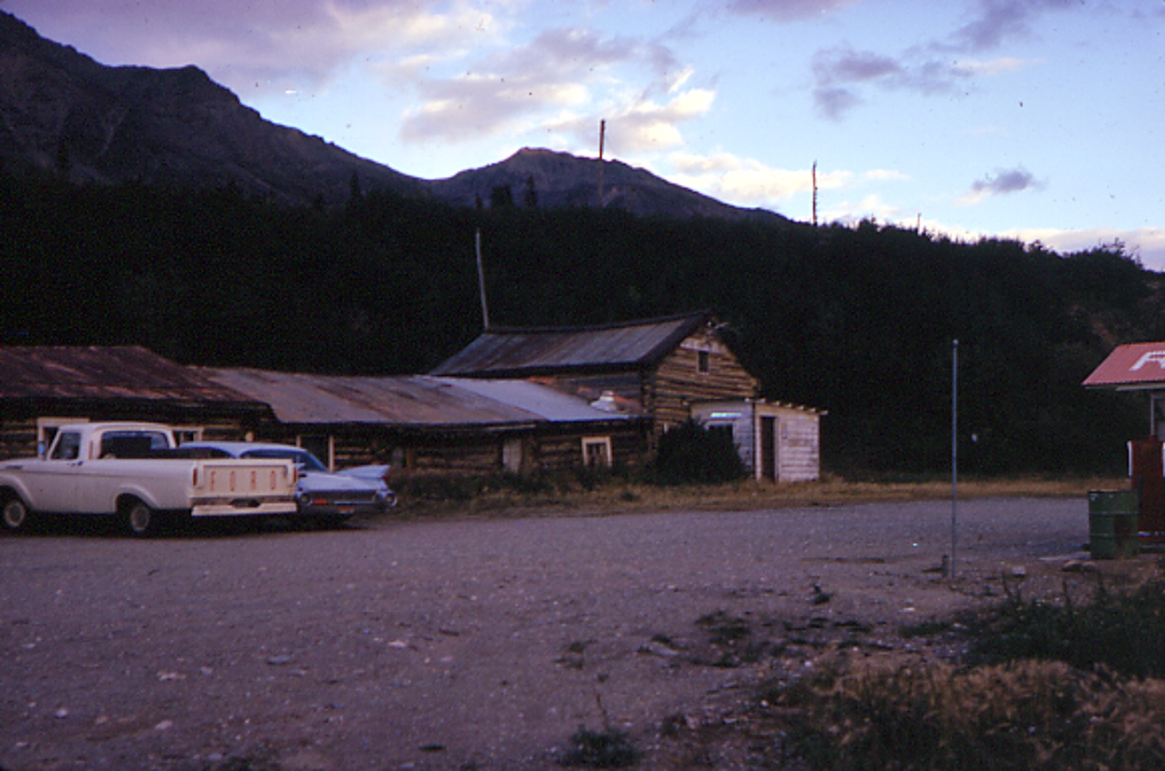
| | 3 — | [log building with sign for Boundry Café, antlers and wagon wheels in yard, truck parked at
left, Yukon; print date Jul 74. Cf. .7-8] |
| | 4 — | [log cabin with partial sod roof, Yukon; print date Jul 74] |
| | 5 — | [two men on log raft floating down river, Yukon; print date Jul 74] |
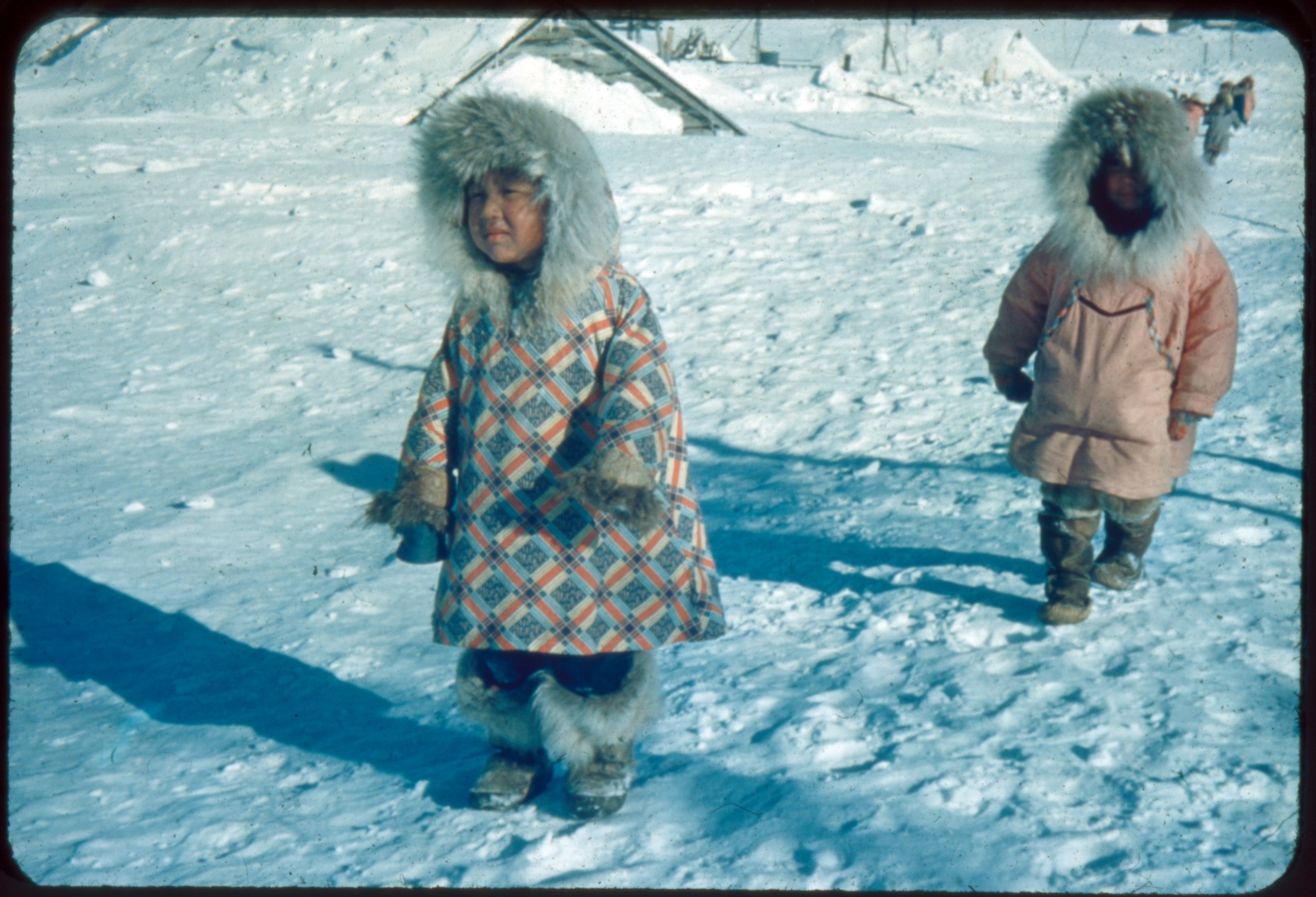
| | 6 — | [young boy standing in dirt yard between dilapidated log cabins, Yukon; print date Jul 74] |
| | 7 — | [log building with sign for Boundry Café, antlers and wagon wheels in yard, truck parked at
left, Yukon; print date Jul 74. Cf. .3, .8] |
| | 8 — | [Boundry Café at right, white building with red trim and sign for “Bar” at left, Yukon; print
date Jul 74] |
| | 9 — | [helicopter parked on beach near floatplane, passengers lined up to board airplane,
sternwheeler passing on river in background, Yukon; print date Aug 73] |
| | 10 — | Dawson City [bird’s eye view of boat launch, buildings, and communication tower,
riverboat docked at right; print date Aug 73] |
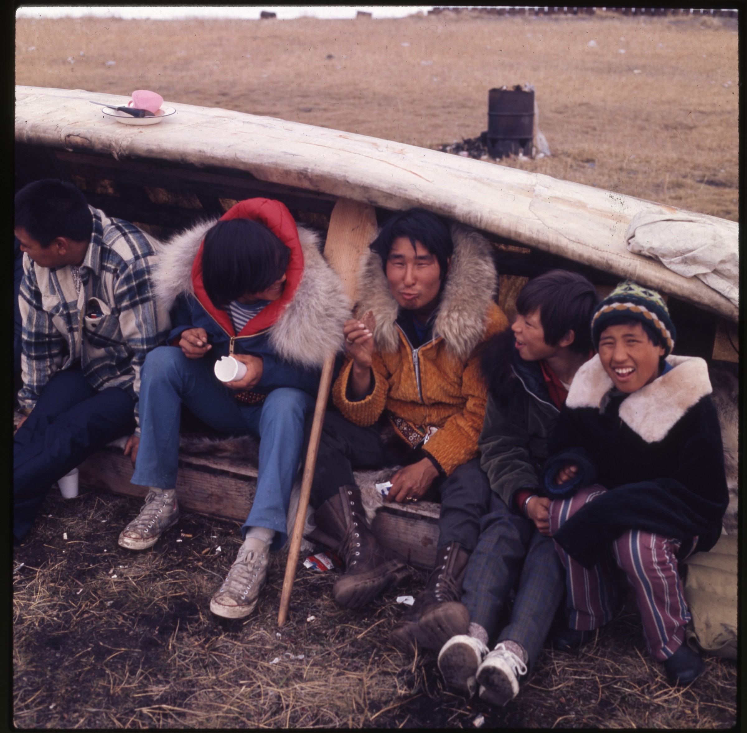
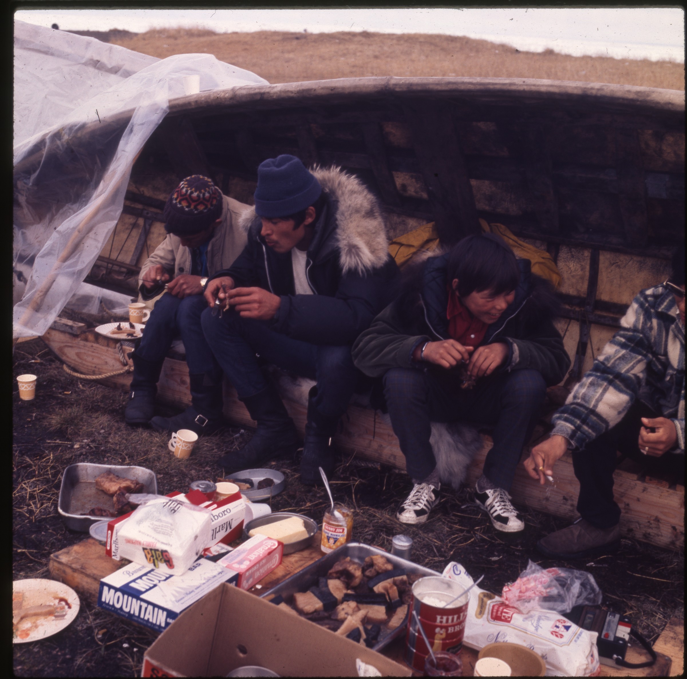
| | 11 — | [stacked firewood and cache next to tarped building, log cabin at right, Yukon; print date
Jul 74] |
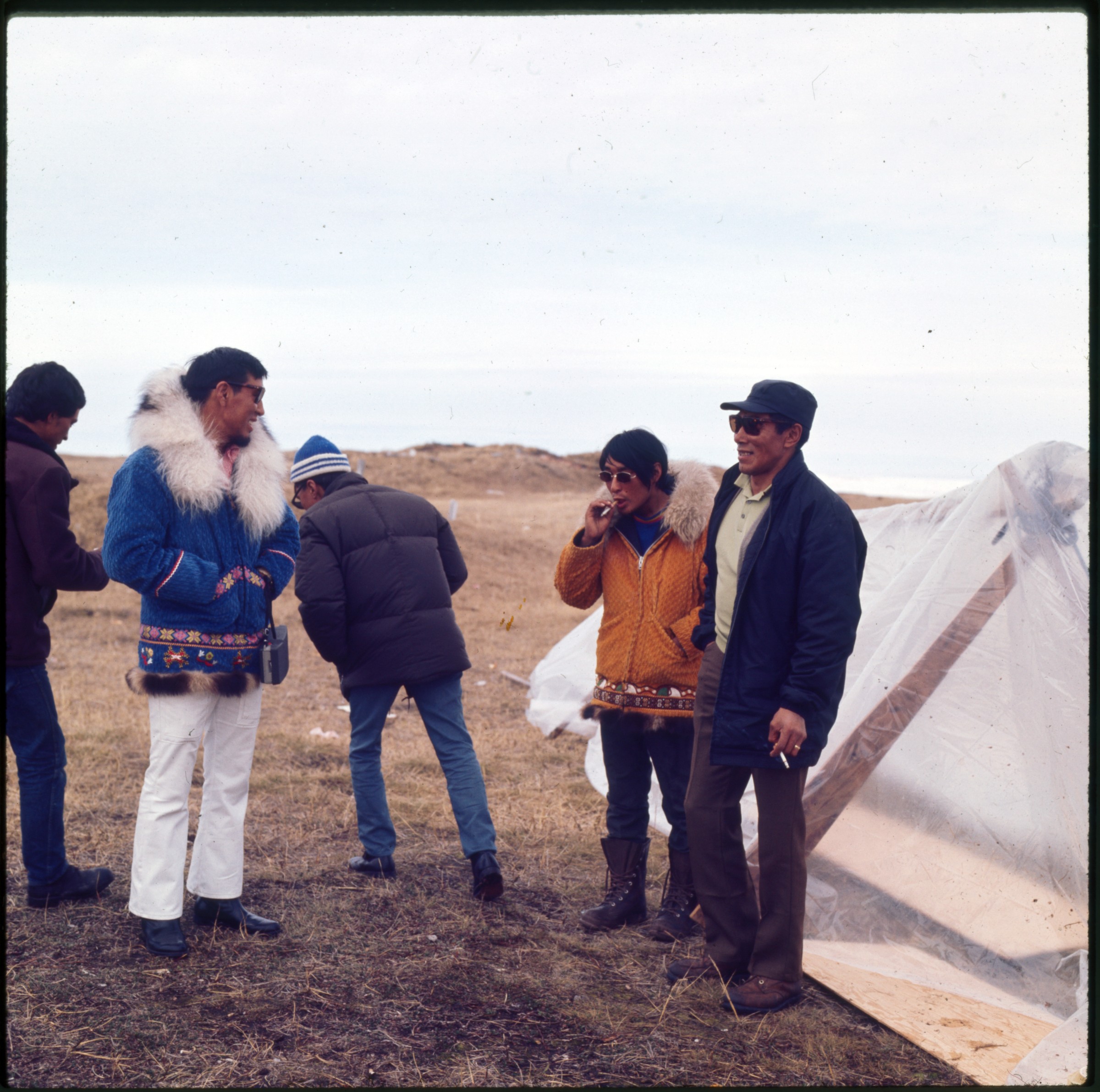
| | 12 — | At Dawson [abandoned gold dredge; print date Aug 73] |
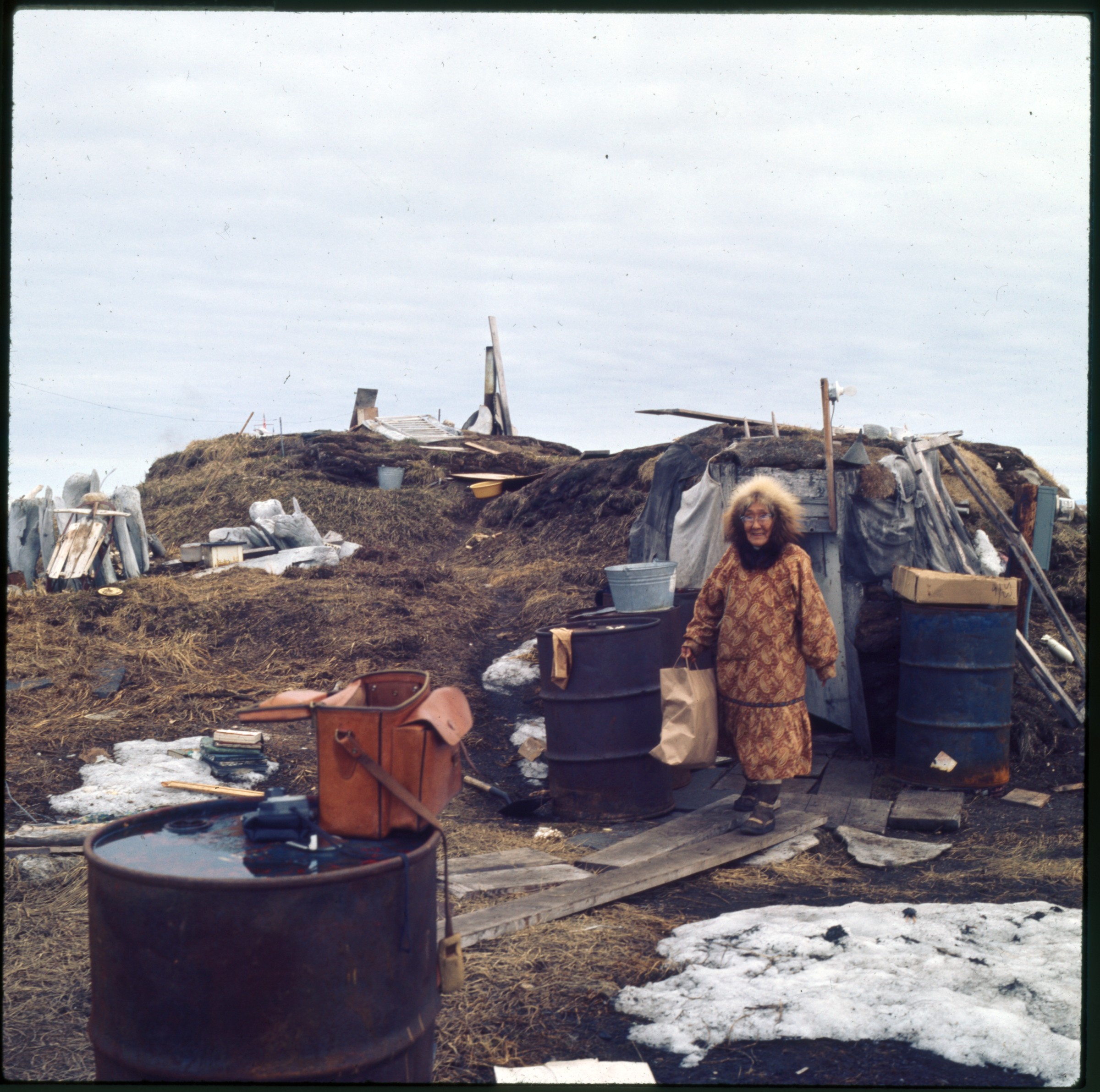
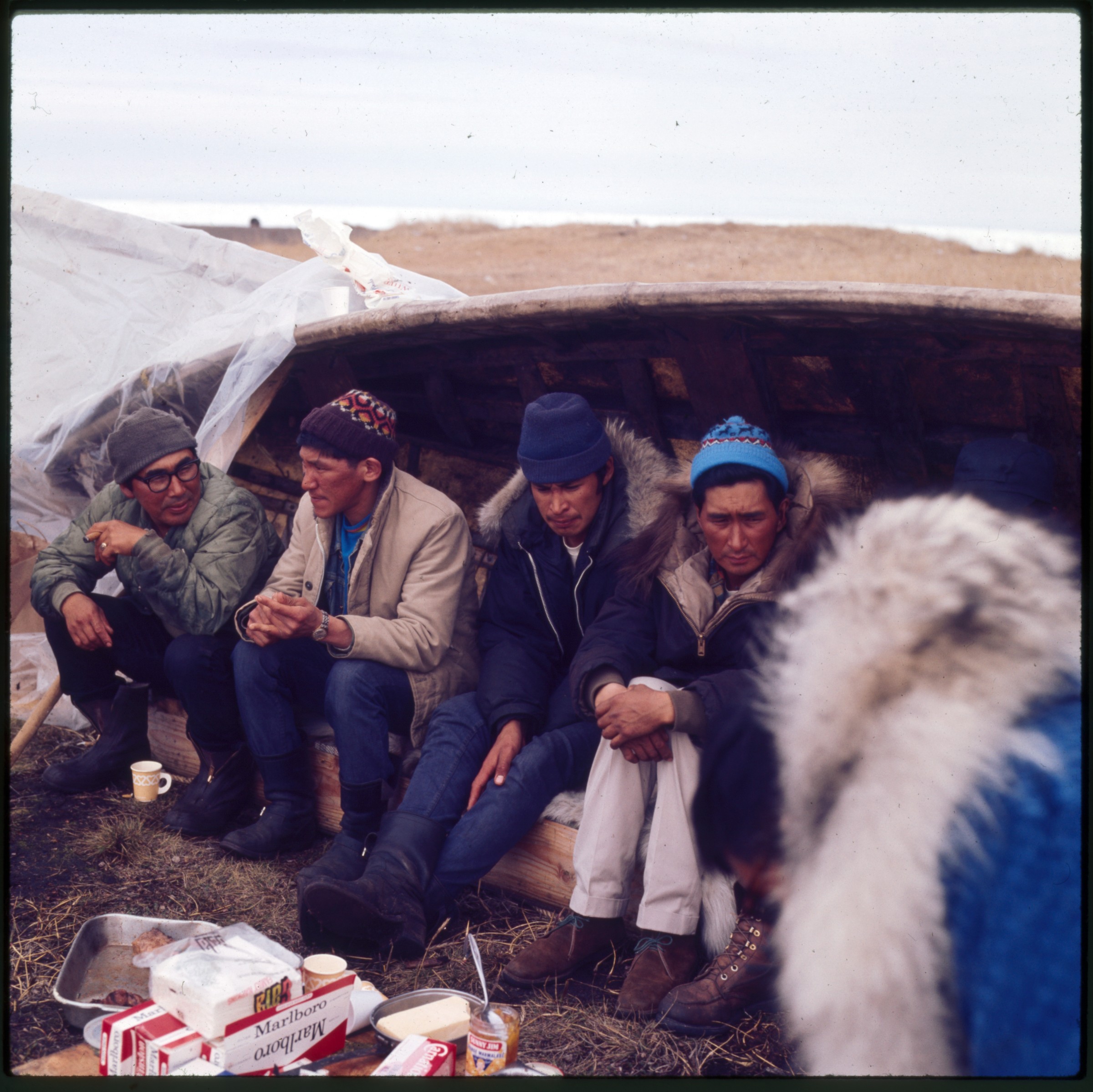
| 13 — | [woman wearing print parka carrying paper bag and walking down boardwalk in front of
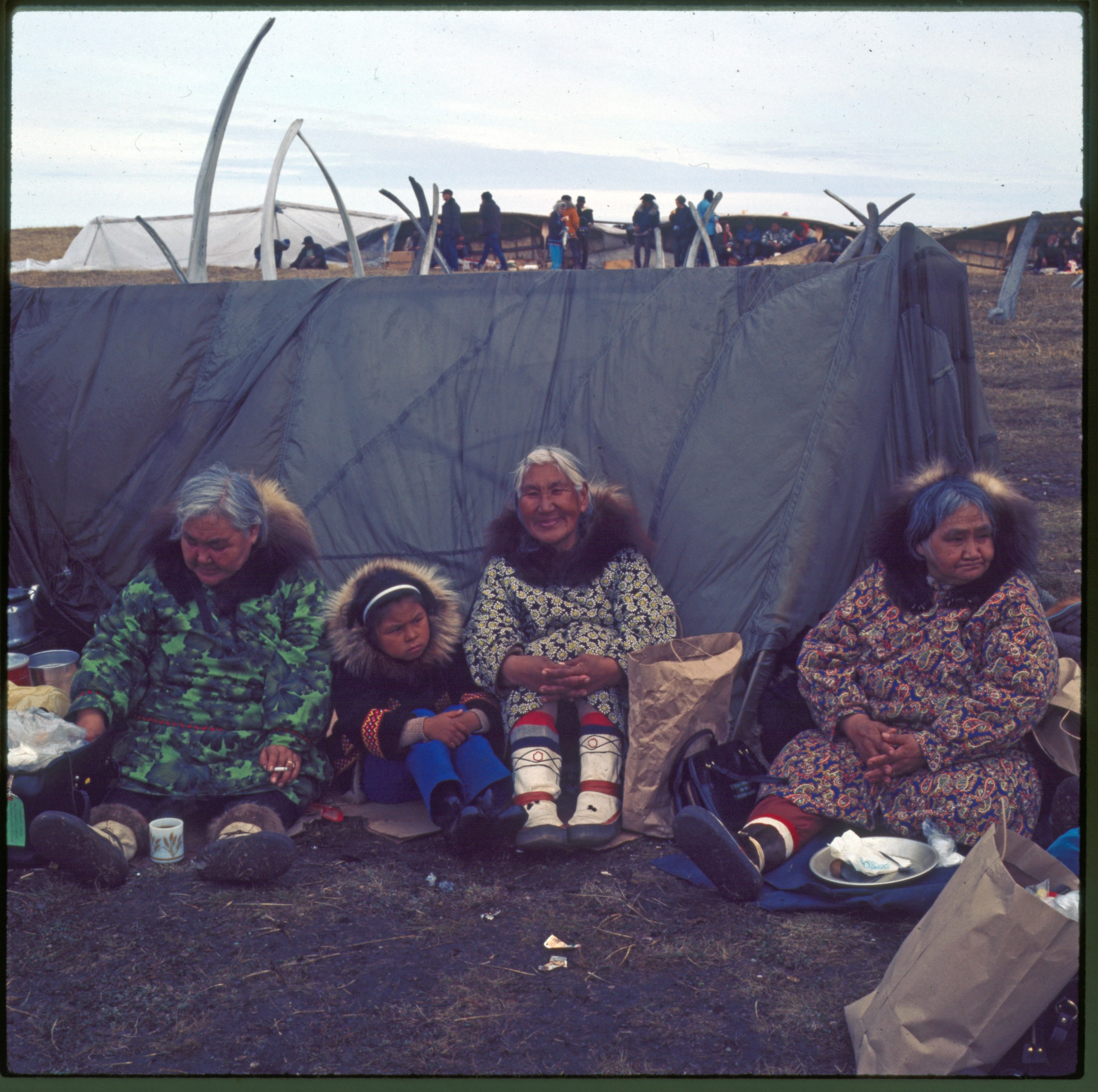
sod house, barrels, books, driftwood, sled, and other items in yard nearby, Point Hope; print
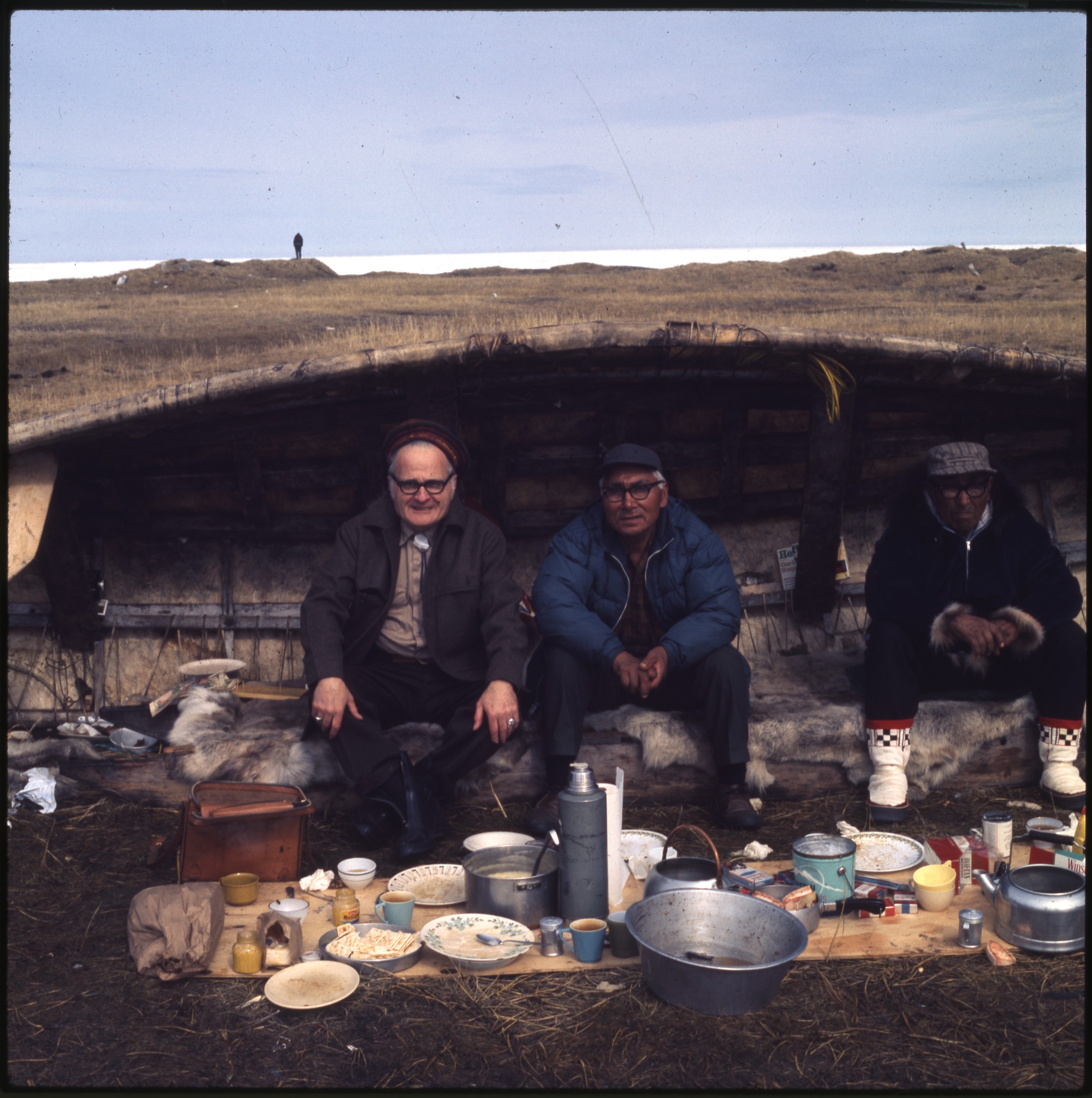
date Jun 72. At AFN 2015, woman identified as Nannie Susailaq Ooyatona (also known as
Nannie Timothy) in front of her home] |
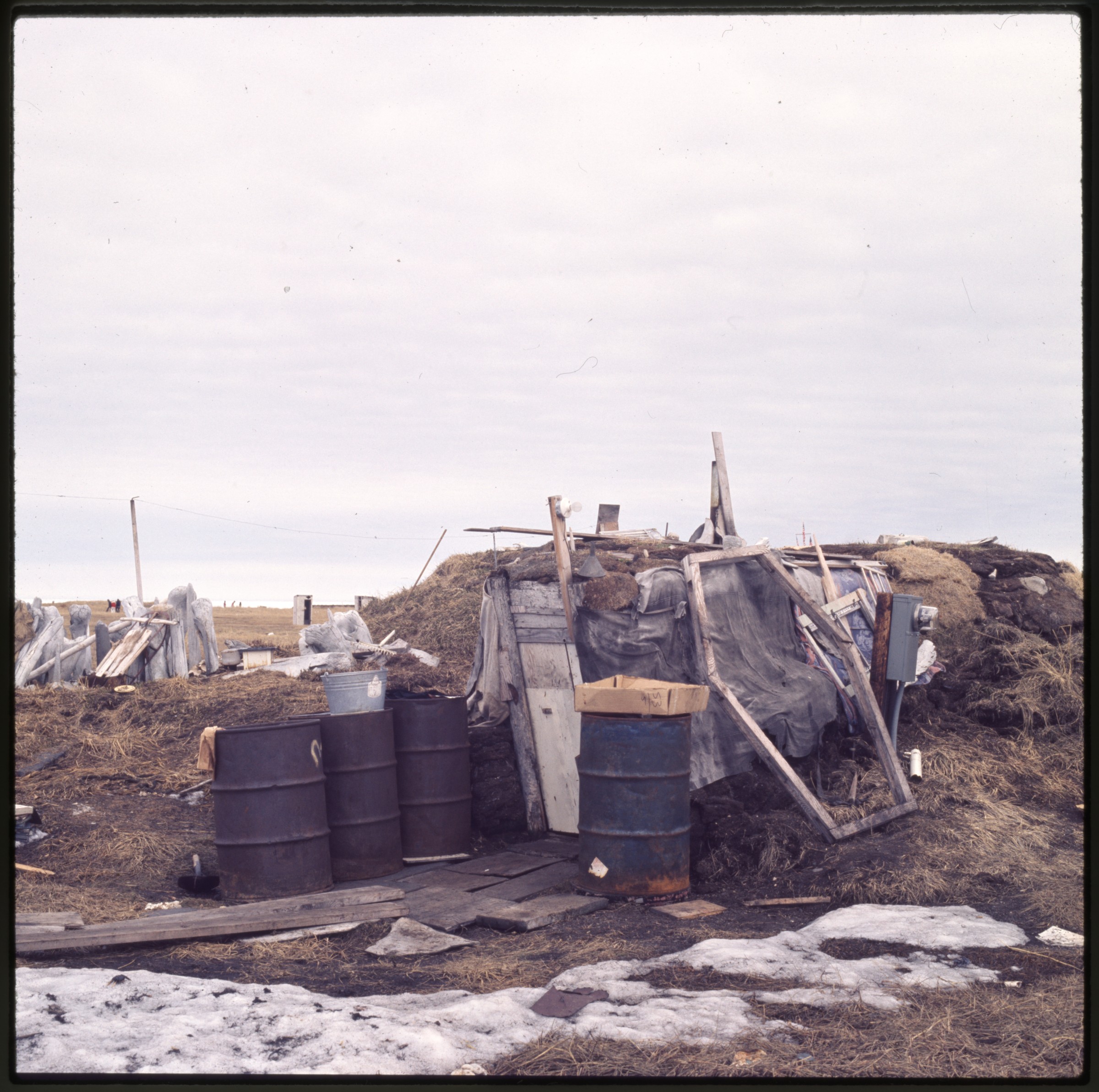
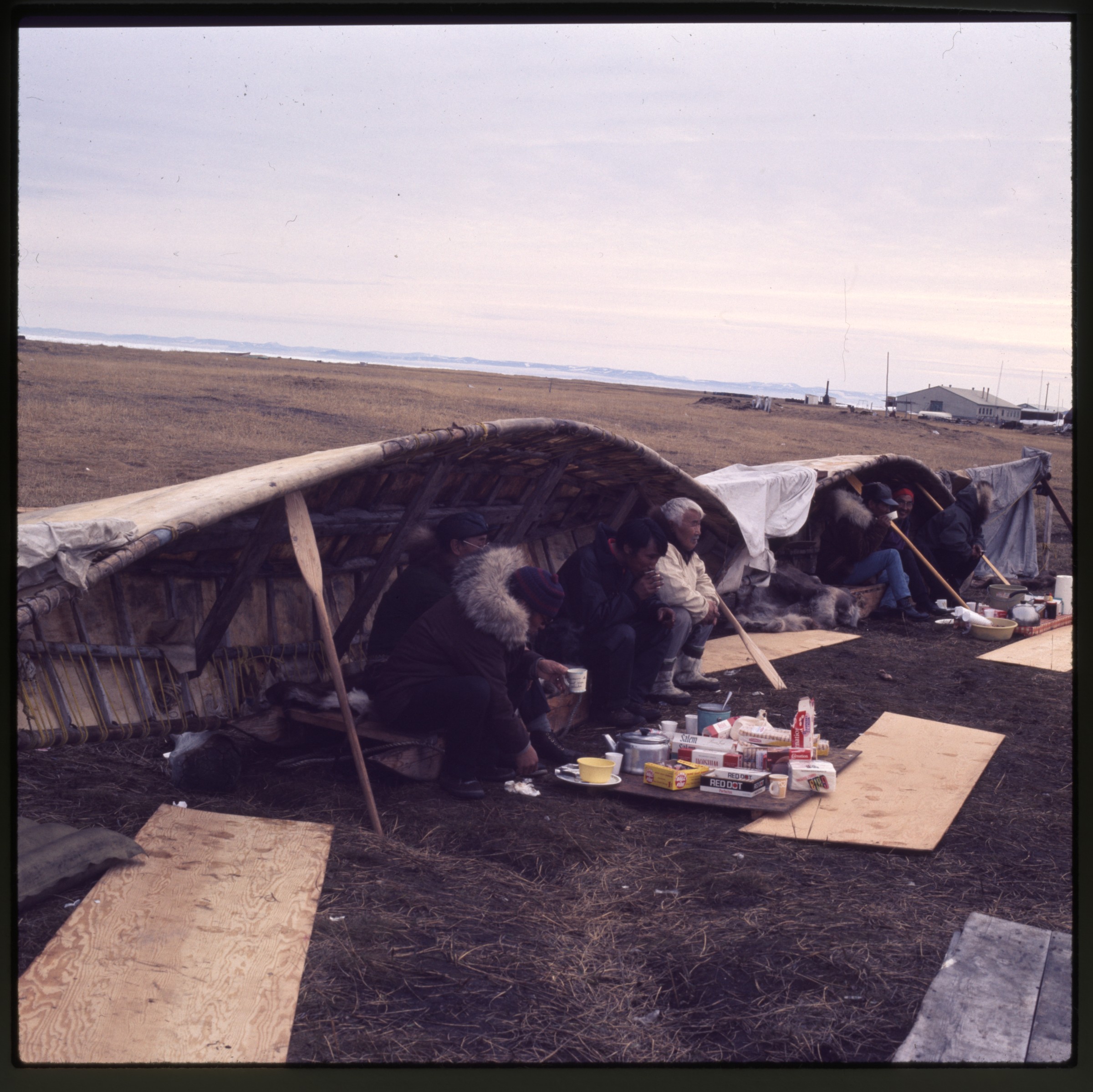
| 14 — | [same dwelling as in .13, Point Hope; print date Jun 72] |
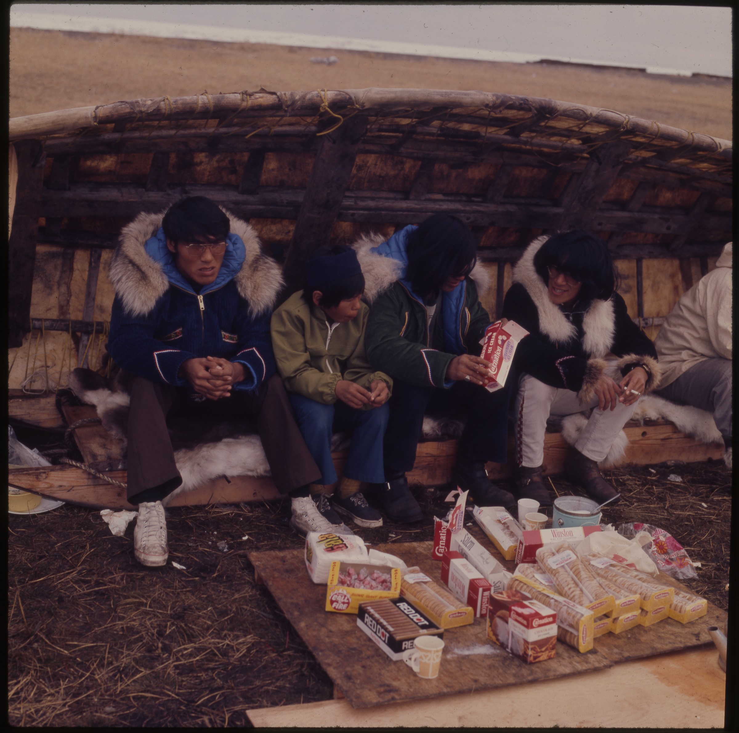
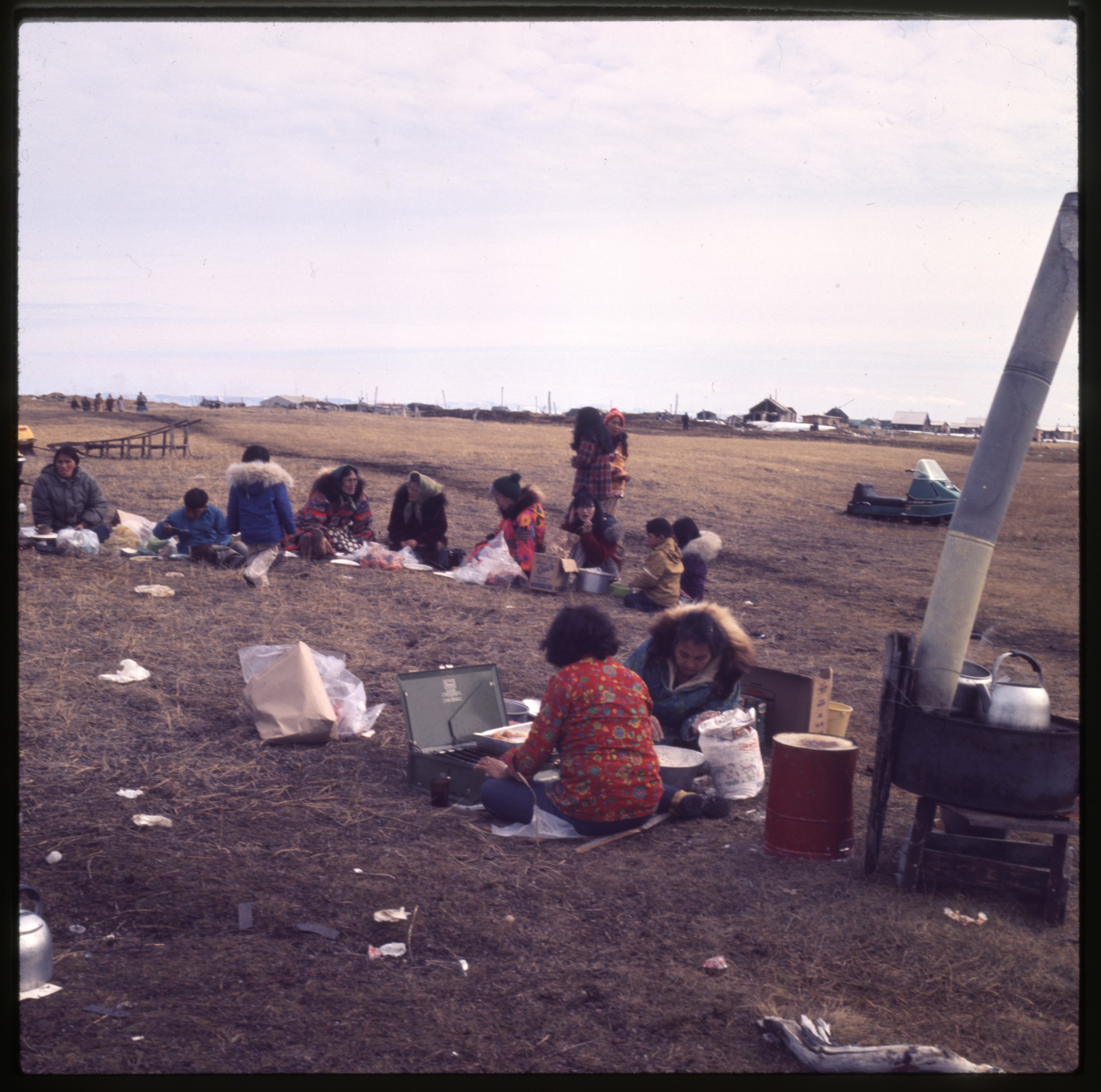
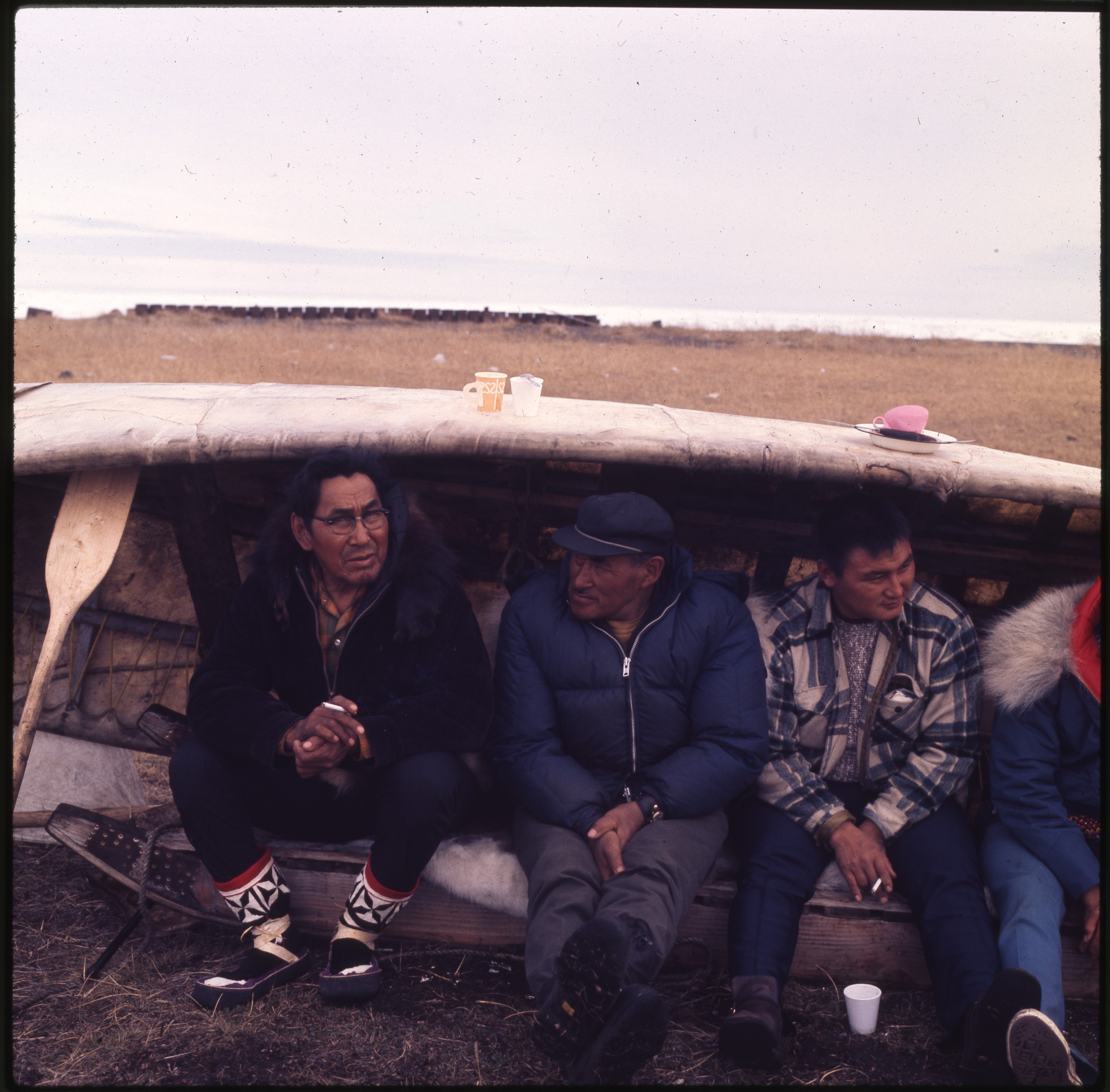
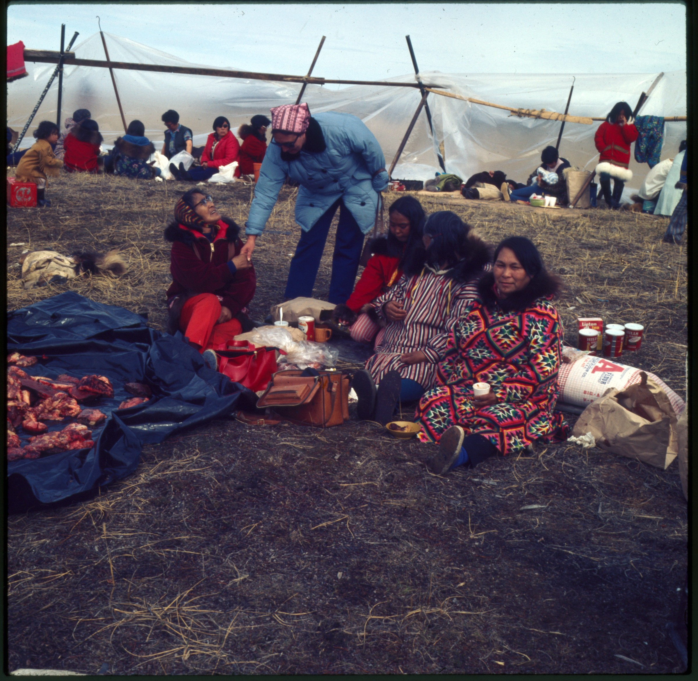
| 15 — | [four men sitting under umiak, one holding box of Carnation Strawberry Ice Cream, man
at right smoking cigarette, candy, crackers, and cigarettes on ground at their feet, Point Hope;
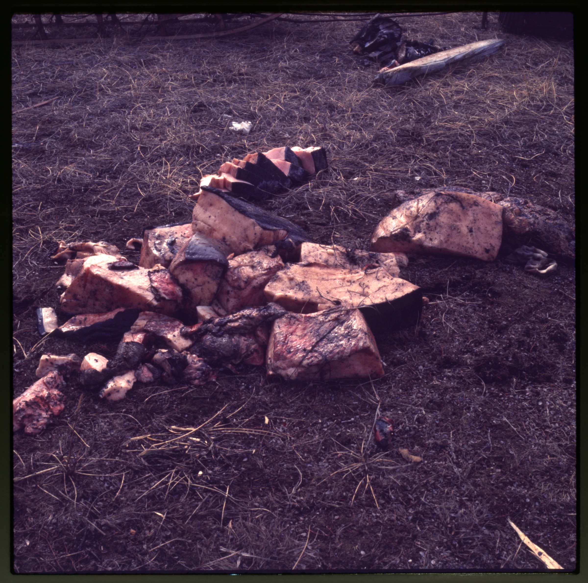
print date Jun 72. At AFN 2015, man at left identified as Harold Koonuk, man at right as Pete
Lisbourne] |
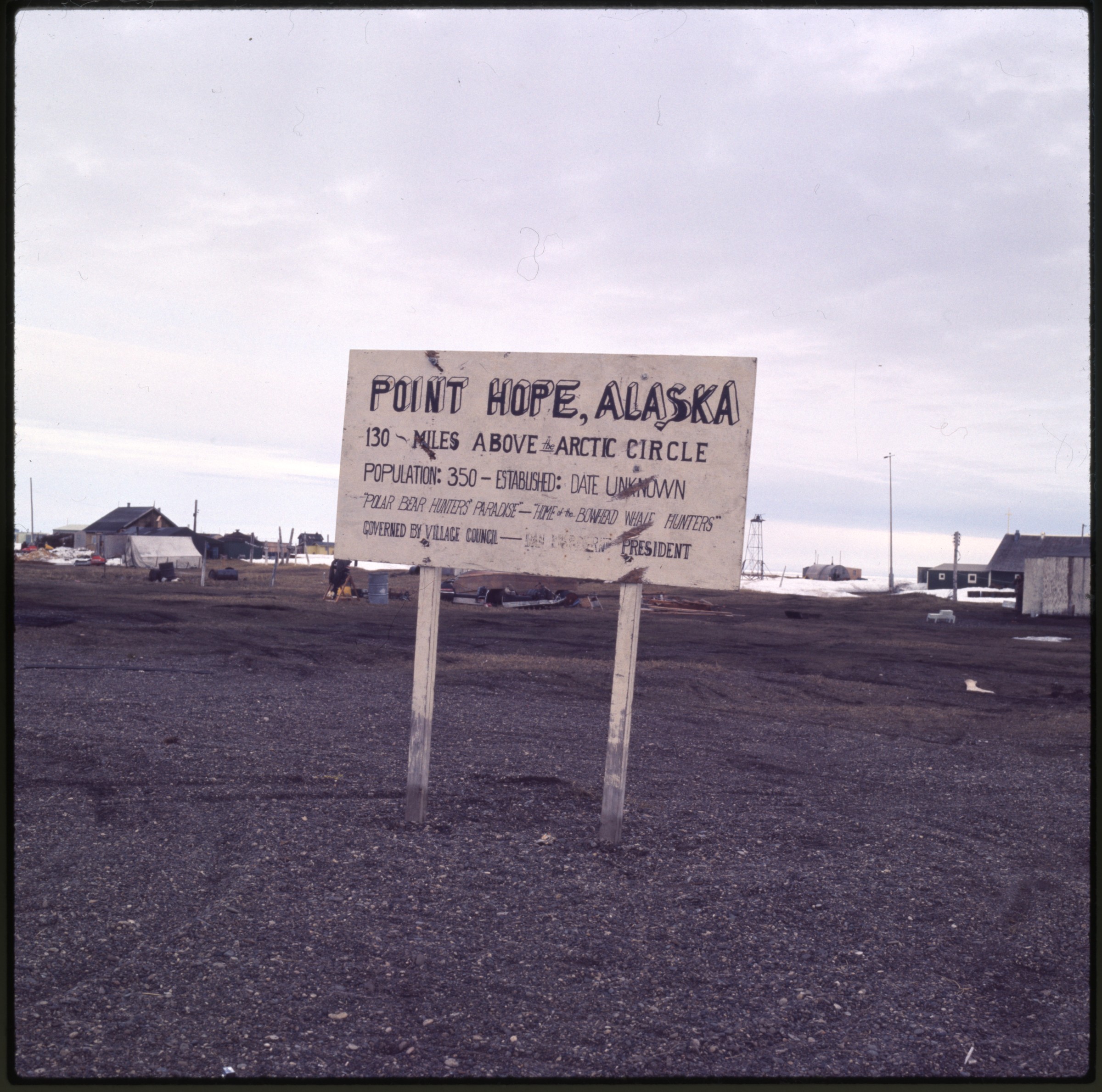
| 16 — | [six men sitting under umiak, cigarettes and food on ground at their feet, Point Hope;
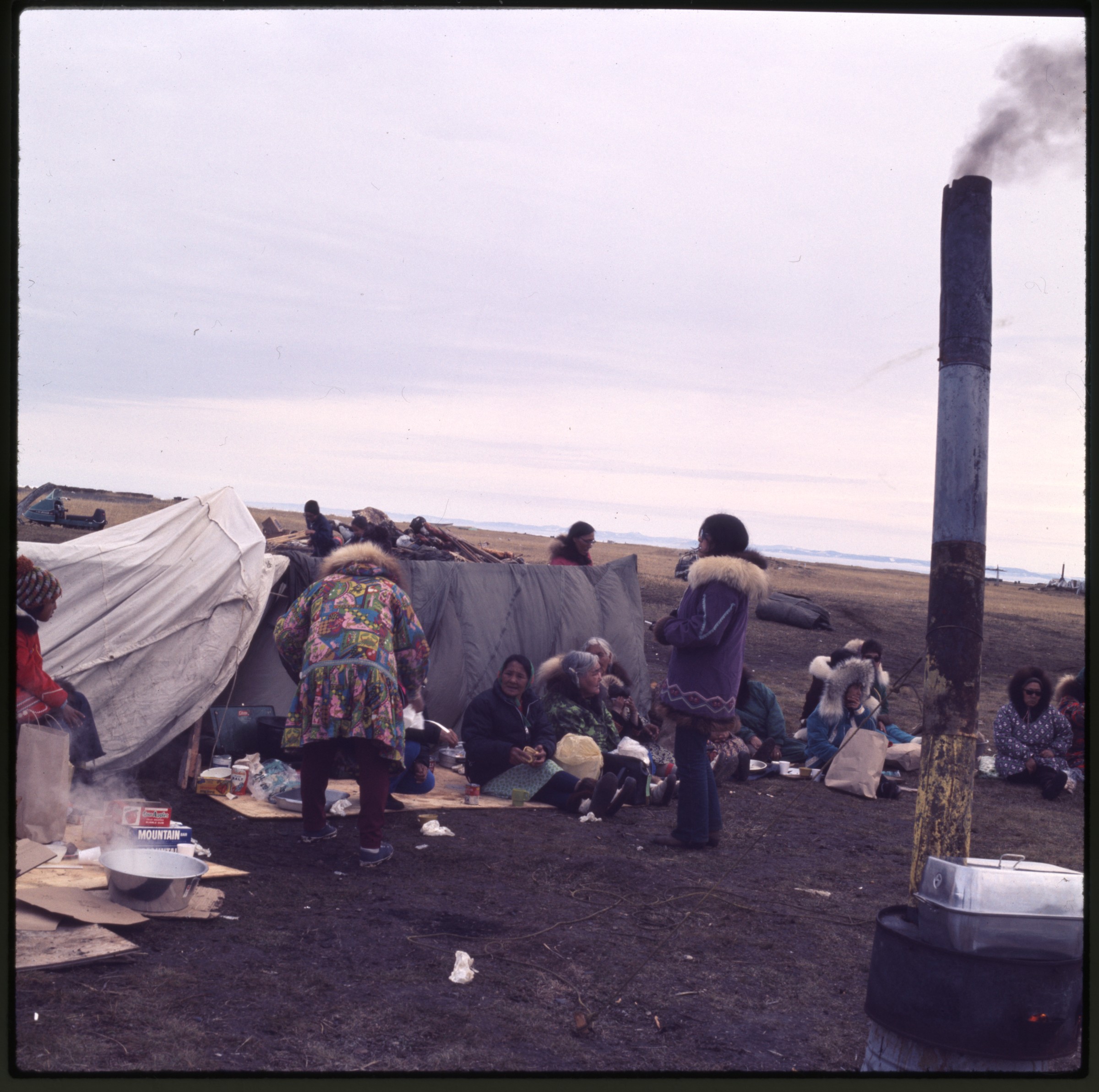
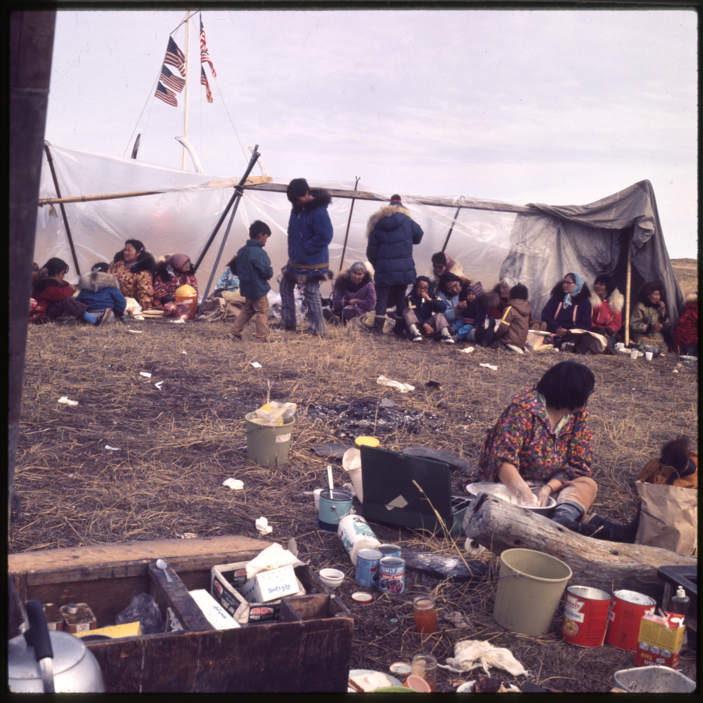
print date Jun 72. At AFN 2015, identified as (left to right): Henry Attungana, [unknown],
Rupert Koonuk, [unknown], Abraham Kowunna, Gil Ozenna] |
| 17 — | [five men standing on tundra, man wearing blue parka with embroidered design holding
camera, two men at right smoking cigarettes, Point Hope; print date Jun 72. At AFN 2015, man
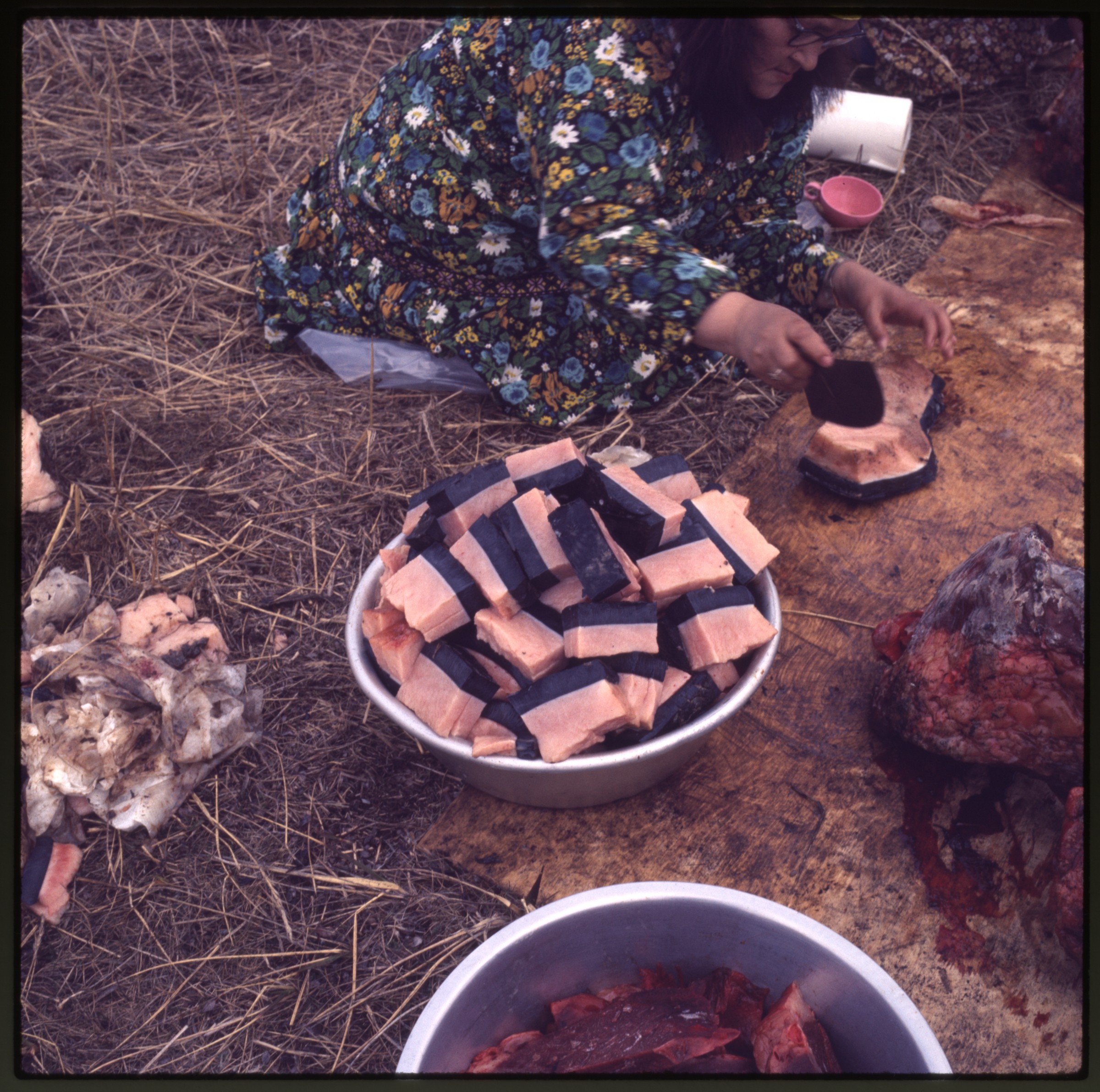
holding camera tentatively identified as Ron Ovik, man at right as Abraham Kowunna] |
| 18 — | [four men sitting under umiak, man at left smoking cigar, Point Hope; print date Jun 72.
At AFN 2015, identified as (left to right): Henry Attungana, [unknown], Rupert Koonuk, Elijah
Rock] |
| 19 — | [three elder women wearing print parkas and young girl sitting next to low tent,
whalebones and umiaks in background, Point Hope; print date Jun 72. At AFN 2015, woman at
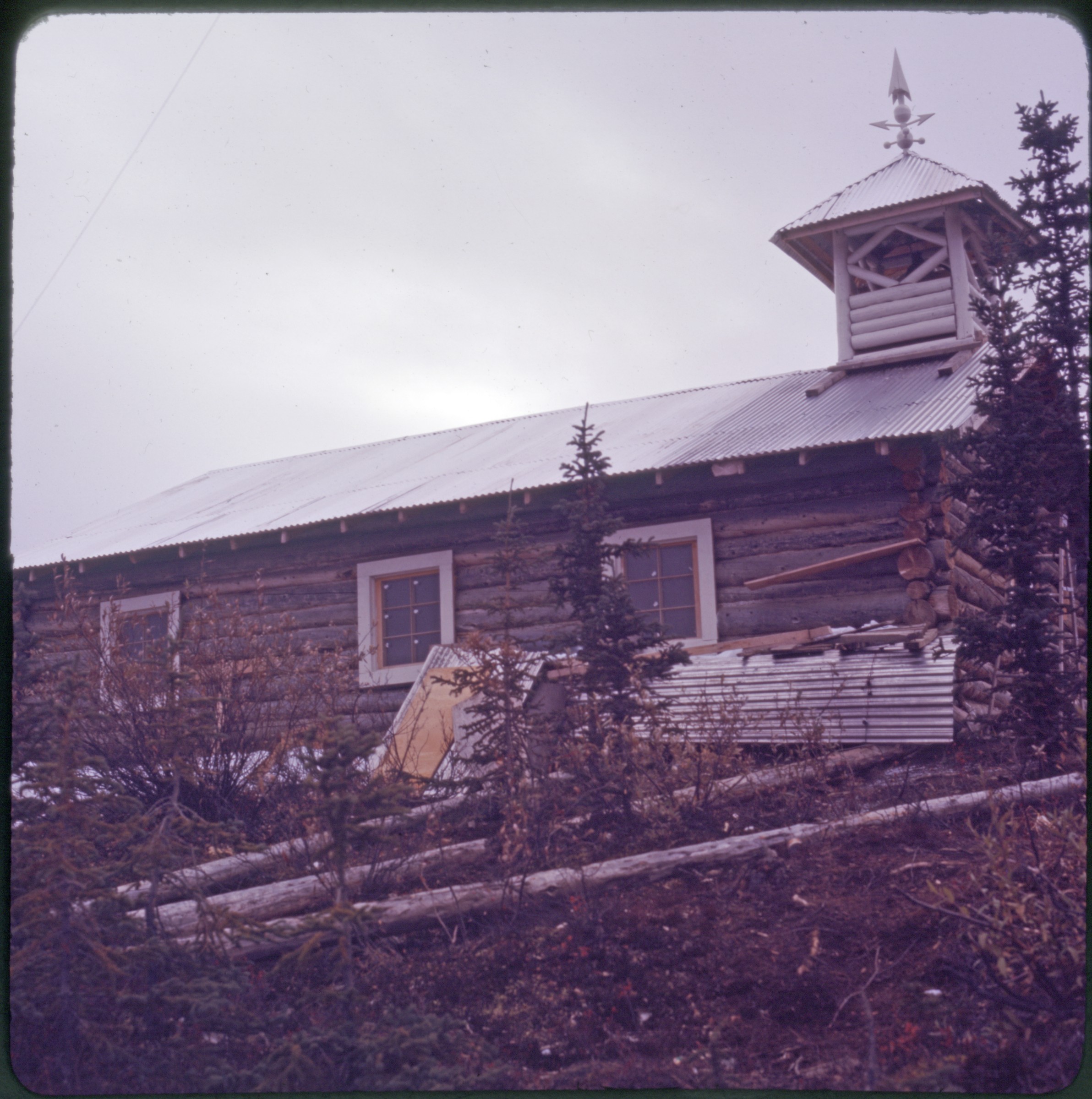
left identified as Beatrice Vincent, woman at right as Daisy Oomittuk, young girl as possibly an
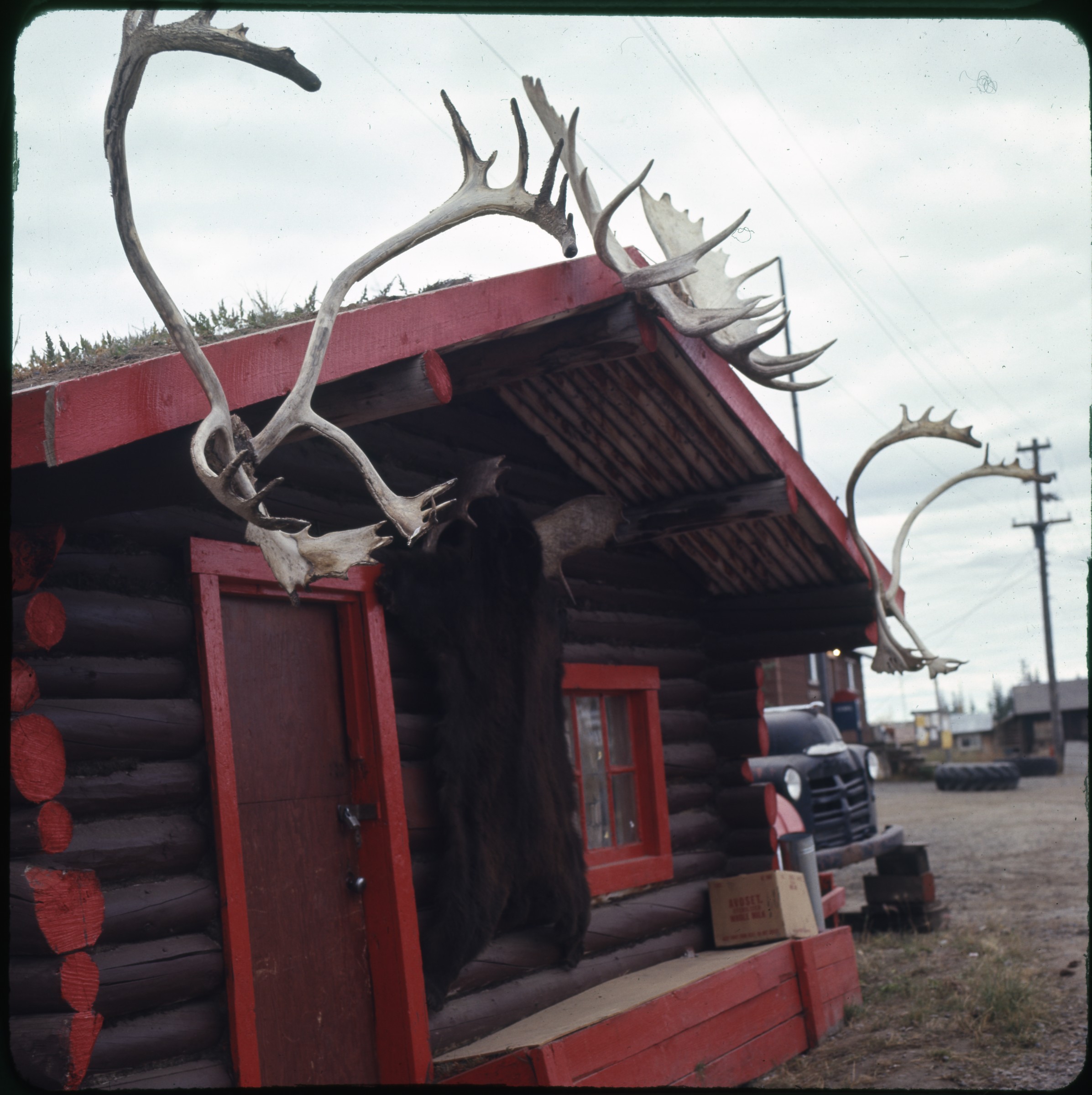
Oktollik] |
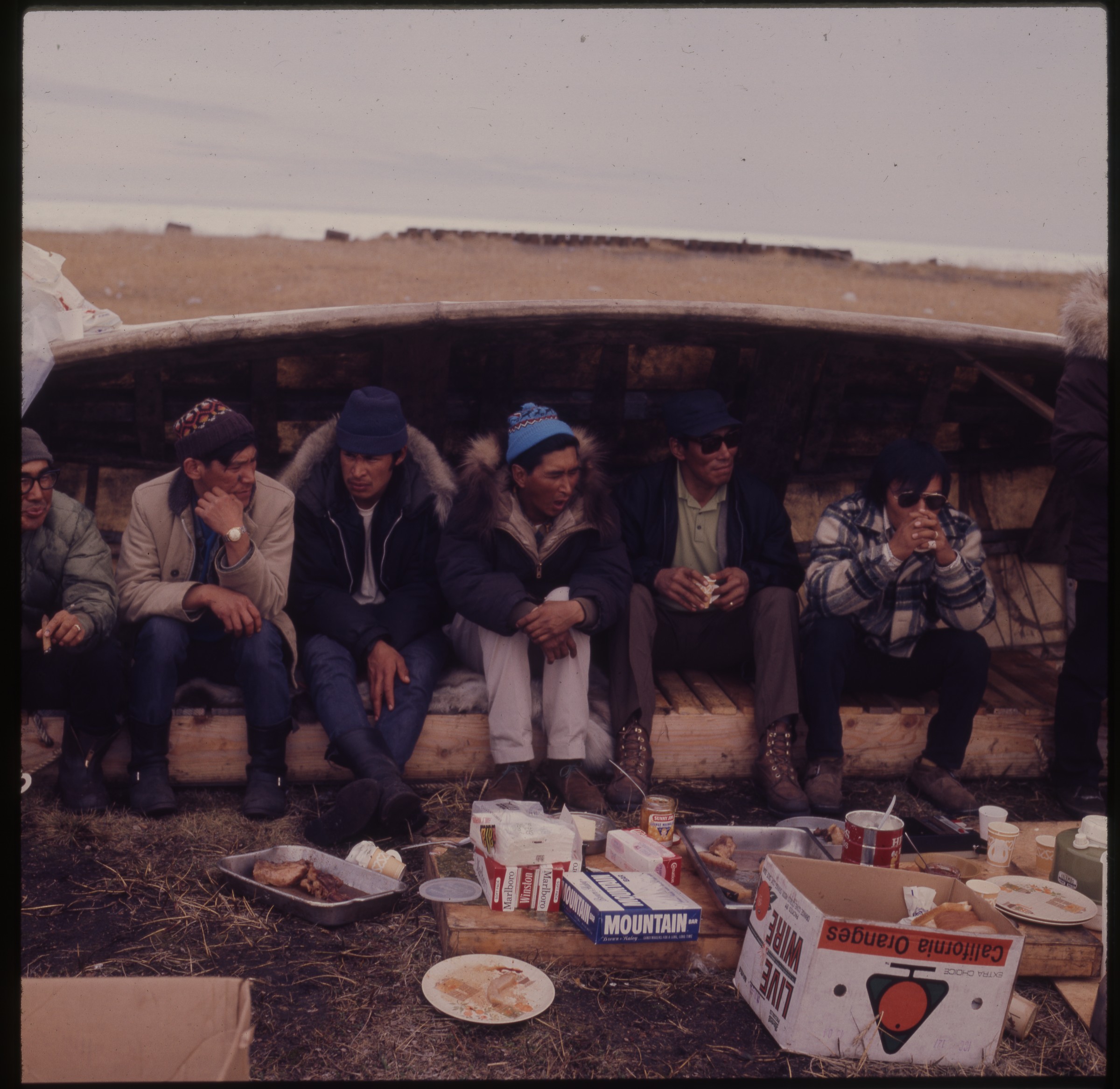
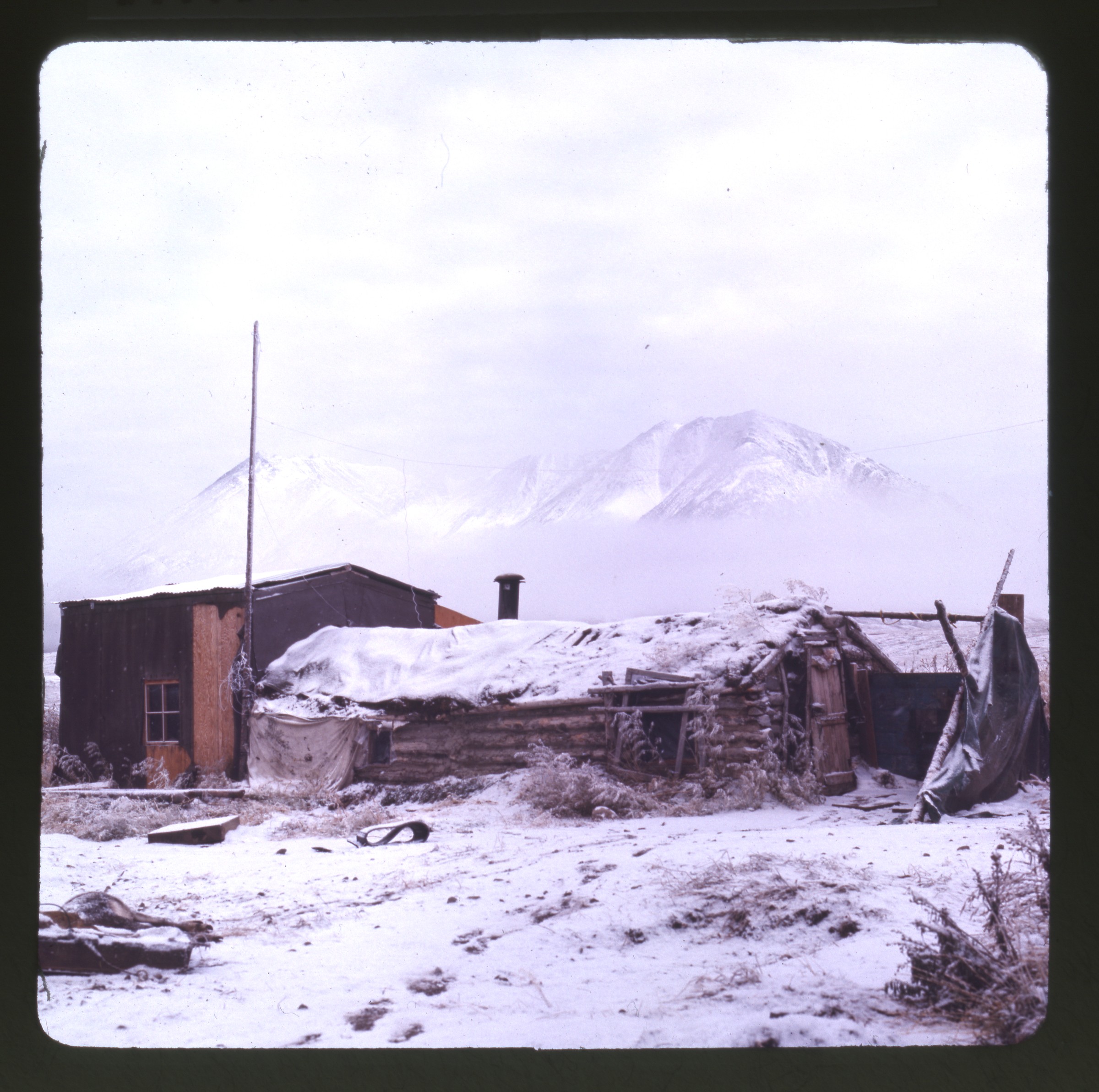
| 20 — | [three men sitting under umiak, food, dishes, and cigarettes on ground at their feet,
possibly Morris Reese at left, Point Hope; print date Jun 72. At AFN 2015, man in center
identified as Fletcher Gregg] |
| 21 — | [five young men sitting under umiak, Point Hope; print date Jun 72; at AFN 2013, men
identified as left to right: ?, ?, Konrad Killigvuk, Gordon Omnik, Gus Kowanna] |
| 22 — | [men sitting under umiaks on tundra, food and supplies on ground, water in background,
buildings at far right, Point Hope; print date Jun 72] |
| 23 — | [women and children seated on tundra, two women cooking over propane stove in
foreground, women in back with whale meat in plastic bags, sled frame at left, snowmachine
at right, buildings in background, Point Hope; print date Jun 72] |
| 24 — | [women seated on tundra near low tent, stove in right foreground, Point Hope; print
date Jun 72] |
| 25 — | [pile of cut whale meat on tundra, Point Hope; print date Jun 72] |
| 26 — | [three men seated under umiak, two smoking cigarettes, Point Hope; print date Jun 72.
At AFN 2015, man at left identified as Uyagaaluk Laurie Kingik, man at right as Willie Omnik] |
| 27 — | [sign reading: “Point Hope, Alaska, 130 miles above the Arctic Circle, population 350,
established date unknown, Polar Bear Hunter’s Paradise, Home of the Bowhead Whale
Hunters, governed by Village Council, [blank] president”; print date Jun 72] |
| 28 — | [women and children seated behind plastic windbreak set up on tundra, woman in
foreground preparing food, cans, paper towels, and other supplies on ground nearby, Point
Hope; print date Jun 72] |
| 29 — | [three young men seated under umiak, two men at left carving with pen knives, food and
cigarettes on ground at their feet, Point Hope; print date Jun 72. At AFN 2015, man out of
frame at right identified as Gil Ozenna] |
| 30 — | [women sitting on tundra near whale meat in foreground, others sitting behind plastic
windbreak in background, Point Hope; print date Jun 72. At AFN 2015, woman at right
identified as Aggie Kowunna, woman at left as Dinah Frankson] |
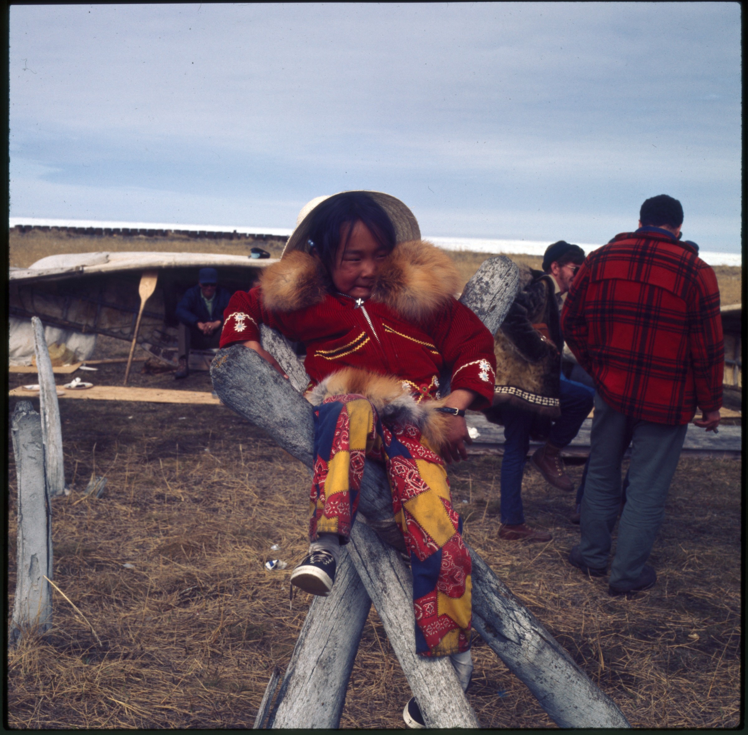
| 31 — | [young girl sitting on top of tripod made of driftwood or whalebone, Point Hope; print
date Jun 72. At AFN 2015, identified as Aggie Frankson]
|
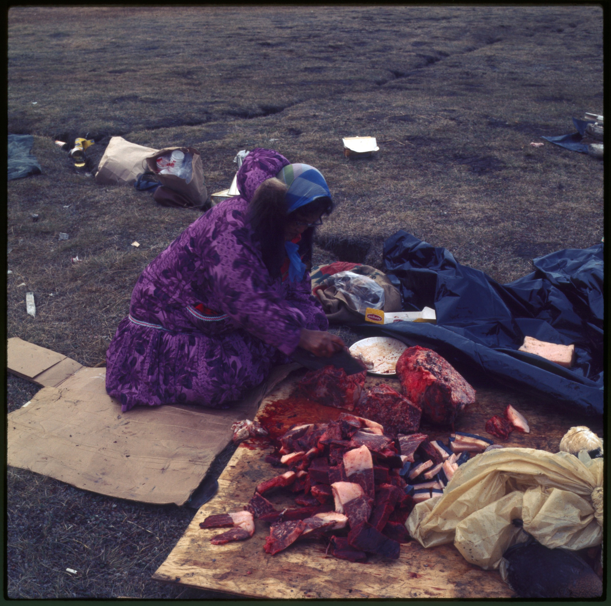
| 32 — | [woman cutting whale meat on tundra, Point Hope; print date Jun 72] |
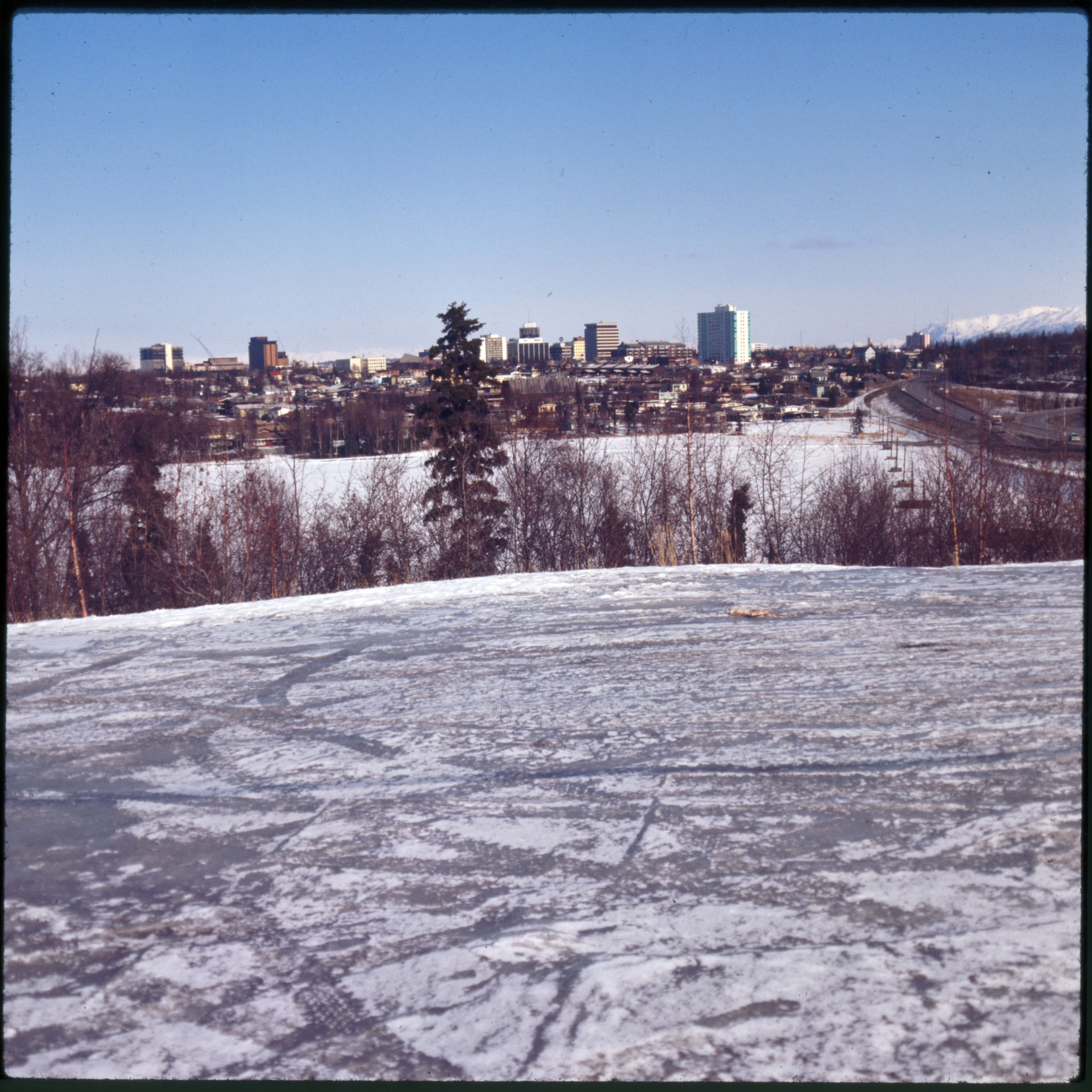
| 33 — | [close-up of whale meat being cut, Point Hope; print date Jun 72] |
| 34 — | [young boy sitting on camp chair next to large can of Morrell Snow Cap Pure Lard, Point
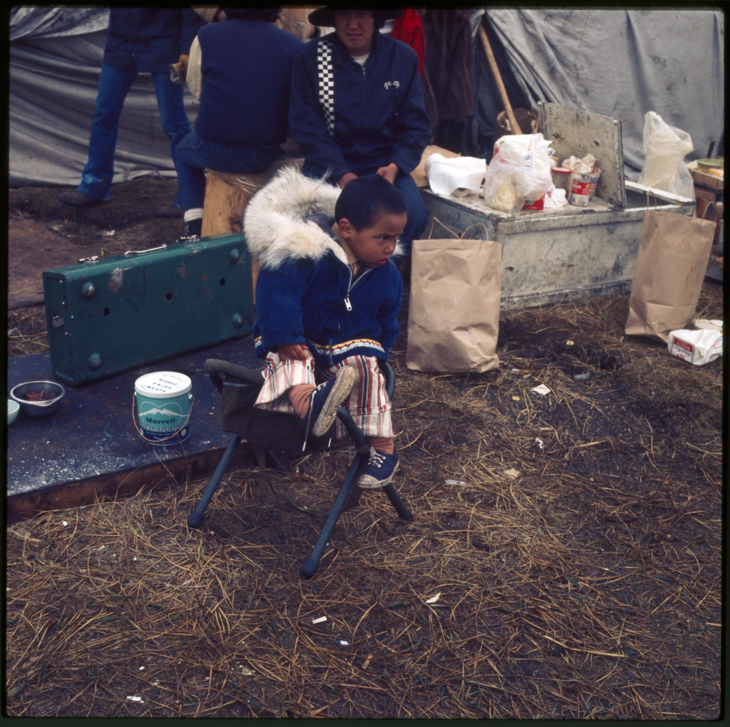
Hope; print date Jun 72] |
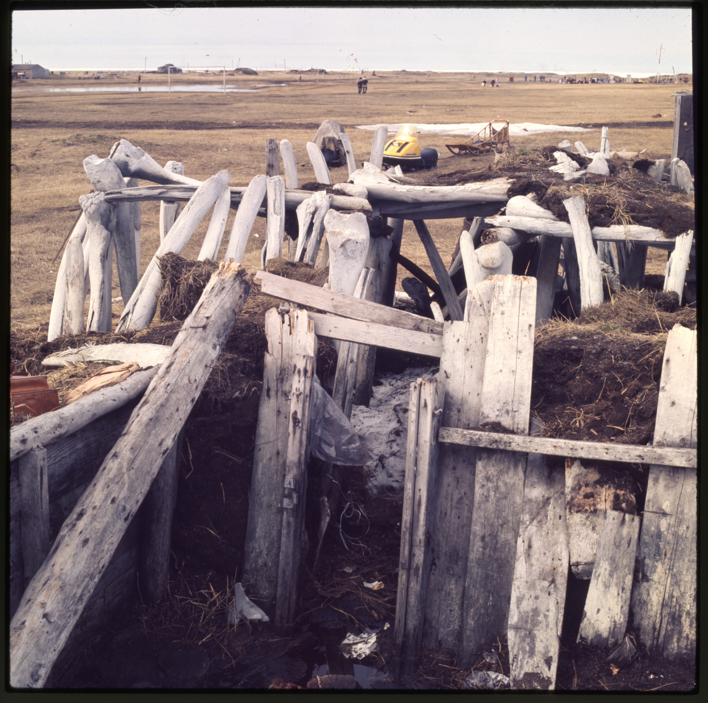
| 35 — | [structure made of whalebones, snowmachine and sled on tundra in background, Point
Hope; print date Jun 72] |
| | 36a — | [five people standing next to milepost sign, Point Hope; print date Jun 72] |
| | 36b — | [skins hanging on drying rack in winter, sled, barrels, and boxes on ground, Point Hope,
no date. Cf. .42] |
| 37 — | [two men seated under umiak, Point Hope; print date Jun 72. At AFN 2015, identified as
Seymour Tuzroyluke at left, Hubert Koonuk at right] |
| 38 — | [log building with corrugated metal roof and weather vane, possibly Mission Church,
Arctic Village, no date. At AFN 2016, location confirmed as Episcopal Church in Arctic Village] |
| 39 — | [log cabin with antlers mounted on roof, Arctic Village, no date. At AFN 2016, location
questioned, suggested location Fort Yukon] |
| 40 — | [dilapidated log cabin with tarp on roof in winter, mountains in background, Arctic
Village, no date. At AFN 2017, location corrected to Anaktuvuk Pass] |
| | 41 — | [winter view of glacier terminus in mountain pass as seen from airstrip, tail of airplane in
foreground with number N4049Q, Arctic Village, no date] |
| | 42 — | [meat hanging on drying rack in winter, Arctic Village, no date] |
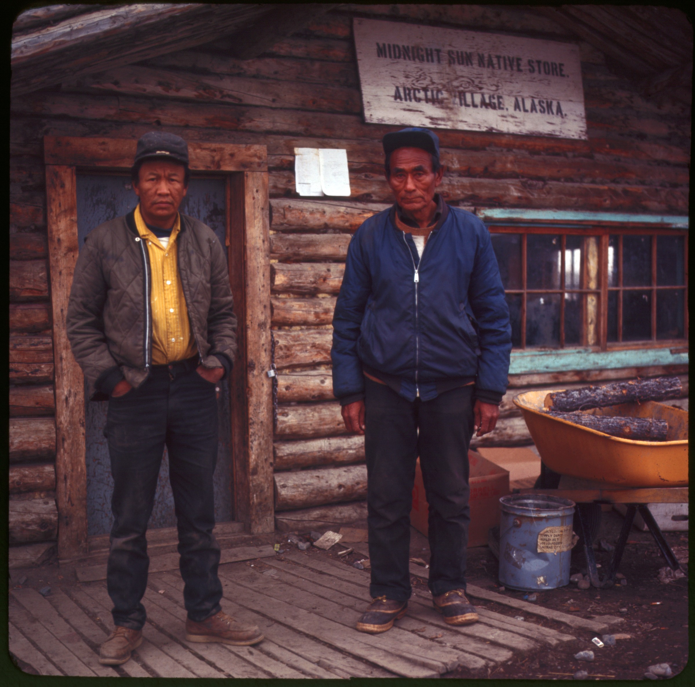
| 43 — | [two men standing outside of Midnight Sun Native Store, Arctic Village, no date. At AFN
2015, men identified as Peter Tritt (left) and Nathaniel Frank (right)] |
| | 44 — | [man, Reese?, standing outside of U.S. Post Office, Arctic Village, no date] |
| | 45 — | [oil drilling rig, North Slope? Early 1970s] |
| | 46 — | [Miles Glacier Bridge on Copper River Highway, showing damage on right end, 1974] |
| | 47 — | [view from dirt road paralleling river to Miles Glacier Bridge, showing damage on left
end, 1974] |
| | 48 — | [man standing on bridge, possibly Reese on Miles Glacier Bridge, backpack propped
against railing on left, 1974. Cf. .53] |
| | 49 — | [similar to .46] |
| | 50 — | [close-up of damaged pier on Miles Glacier Bridge, 1974. Cf. .52, .54] |
| | 51 — | [view down Miles Glacier Bridge to barricade at closure, 1974] |
| | 52 — | [similar to .50] |
| | 53 — | [man standing on bridge, backpack propped against railing on left, 1974. Cf. .48] |
| | 54 — | [similar to .50] |
| | 55 — | [similar to .46] |
| | 56 — | [bird’s eye view of bridge across Copper River, McCarthy Road, 1974] |
| | 57 — | [view from pullout of bridge across Copper River, McCarthy Road, 1974] |
| | 58 — | [distant view of automobile crossing high trestle bridge over Kuskulana River Canyon,
McCarthy Road, 1974. Cf. .65] |
| | 59 — | [close-up of trestle bridge, McCarthy Road, 1974] |
| | 60 — | [view down unpaved McCarthy Road, 1974] |
| | 61 — | [view down unpaved McCarthy Road to trestle bridge, possibly at Gilahina River, 1974] |
| | 62 — | [close-up of trestle bridge, McCarthy Road, 1974]
|
| | 63 — | [similar to .62] |
| | 64 — | [low wooden bridge across river in foreground, trestle bridge in background, possibly at
Gilahina River, McCarthy Road, 1974] |
| | 65 — | [similar to .58] |
| | 66 — | missing |
| | 67 — | [passengers unloading luggage from Grumman Goose airplane on gravel beach, fish
drying racks at right, Kodiak Western Airlines, tail number N2845D?, 1974] |
| | 68 — | [interpretive marker for Edgerton Cutoff; print date May 74] |
| | 69 — | [winter view of C Street bridge from Government Hill, looking south, with Alaska Railroad
yards, buildings in downtown Anchorage; print date Mar 77. Cf. .72] |
| | 70 — | [Anchorage, winter view of Alaska Railroad yards from Government Hill, looking
southeast, Alaska Native Hospital in distance; print date Mar 77. Cf. .76-77] |
| 71 — | [winter view of downtown Anchorage from hill above Westchester Lagoon looking north,
with Captain Cook Hotel, Unocal and other buildings, Minnesota Drive at right; print date Mar
77. Cf. .73, .75] |
| | 72 — | [Anchorage, winter view of C Street Bridge from Government Hill; print date Mar 77. Cf.
.69] |
| | 73 — | [similar to .71] |
| | 74 — | [automobiles in parking lot, Sunshine Plaza on left, parking meters along Third Avenue at
right, with Anchorage Westward Hotel towers; print date Mar 77] |
| | 75 — | [similar to .71] |
| | 76 — | [similar to .70] |
| | 77 — | [similar to .70] |
| | 78 — | [Anchorage Westward Hotel tower, looking south across Third Avenue; no date]
35mm slides |
| | 79 — | [damage to home in residential area, Anchorage, 1964 Earthquake; print date Apr 64] |
| | 80 — | [collapsed cinder block wall, commercial business, Anchorage, 1964 Earthquake; print
date Apr 64. Cf. .95, .141] |
| | 81 — | [damage to Alaska Sales & Service, Anchorage, 1964 Earthquake; print date Apr 64] |
| | 82 — | [structural damage, Alaska Sales & Service? Anchorage, 1964 Earthquake; print date Apr
64] |
| | 83 — | [damage to Cordova Building, Anchorage, 1964 Earthquake; print date Apr 64] |
| | 84 — | [structural damage to business, Anchorage, 1964 Earthquake; print date Apr 64] |
| | 85 — | [damage to cinder block building, Anchorage, 1964 Earthquake; print date Apr 64] |
| | 86 — | [close-up of fissure in ground, pile of firewood at right, Anchorage, 1964 Earthquake;
print date Jul 64] |
| | 87 — | [damage to Alaska Sales & Service, Anchorage, 1964 Earthquake; print date Apr 64] |
| | 88 — | [damage to Alaska Sales & Service, Anchorage, 1964 Earthquake; print date Apr 64] |
| | 89 — | [damage to Anchorage Cold Storage, 1964 Earthquake; print date Apr 64] |
| | 90 — | [fissure in ground in residential area, Anchorage, 1964 Earthquake; print date Jul 64] |
| | 91 — | [parking lot, buildings, Anchorage, 1964 Earthquake; print date Apr 64] |
| | 92 — | [damage to Alaska Sales & Service, sign for Anchorage Vacuum & Sewing Center in
foreground, 1964 Earthquake; print date Apr 64]
|
| | 93 — | [damage to Alaska Sales & Service, Anchorage, 1964 Earthquake; print date Apr 64] |
| | 94 — | [structural damage to business, man walking past Chevron gas station in foreground,
Anchorage, 1964 Earthquake; print date Apr 64] |
| | 95 — | [man, possibly Reese, standing on sidewalk next to collapsed cinder block wall,
Anchorage, 1964 Earthquake; print date Apr 64. Cf. .80] |
| | 96 — | [damage to Alaskan Hotel, Valdez, 1964 Earthquake; print date Jul 64] |
| | 97 — | [damaged boat, Harvester 1 out of Valdez, washed up on shore, 1964 Earthquake; print
date Jul 64] |
| | 98 — | [damaged boats, Joddha and Harvester 1 out of Valdez, washed up on shore, tanks in
background, right, 1964 Earthquake; print date Jul 64] |
| | 99 — | [trucks parked next to damaged boat, Valdez, 1964 Earthquake; print date Jul 64] |
| | 100 — | [braces holding up exterior wall of Gilson’s Grocery, Valdez, 1964 Earthquake; print
date Jul 64] |
| | 101 — | March 27, 1964 Earthquake [original caption covered by slide label. Commercial slide.
View down damaged Alaska Railroad track] |
| | 102 — | [view down damaged Alaska Railroad track, 1964 Earthquake; print date Jul 64] |
| | 103 — | [view down damaged Alaska Railroad track, train on siding at right, 1964 Earthquake;
print date Jul 64] |
| | 104 — | [damaged road bridge, river at left, Turnagain Arm area, 1964 Earthquake; print date Jul
64] |
| | 105 — | [view across river, replacement bridge at right, pieces of concrete from original bridge
on far shore, Turnagain Arm area, 1964 Earthquake; print date Jul 64] |
| | 106 — | [view from level of replacement bridge to damaged original bridge in riverbed
underneath, Turnagain Arm area, 1964 Earthquake; print date Jul 64] |
| | 107 — | [close-up of fissures in ground next to unpaved road, Turnagain Arm area, 1964
Earthquake; print date Jul 64] |
| | 108 — | [view down snowy road, showing snow slides in surrounding mountains, Turnagain Arm
area, 1964 Earthquake; print date Jul 64] |
| | 109 — | [close-up of damage to road bridge, Turnagain Arm area, 1964 Earthquake; print date
Jul 64] |
| | 110 — | [close-up of section of road bridge laying in river, Turnagain Arm area, 1964
Earthquake; print date Jul 64] |
| | 111 — | #84a. Stewart’s Photo Shop [original caption covered by slide label. Commercial slide.
View down large fissure in center of Seward Highway, Portage area, 1964 Earthquake] |
| | 112 — | Cracked highway, Portage, Alaska, March 27, 1964, Earthquake [commercial slide.
Similar to .111] |
| | 113 — | [damage to Government Hill school, Anchorage, 1964 Earthquake; print date Apr 64] |
| | 114 — | [lifted ground in foreground, possibly Government Hill school playground, downtown
Anchorage in background, Government Hill, 1964 Earthquake; print date Jul 64. Cf. .117, .119] |
| | 115 — | [damage to Government Hill school, Anchorage, 1964 Earthquake; print date Apr 64] |
| | 116 — | [damage to Government Hill school, Anchorage, 1964 Earthquake; print date Apr 64] |
| | 117 — | [lifted ground in foreground, Government Hill school playground, 1964 Earthquake;
print date Jul 64. Cf. .114] |
| | 118 — | [damage to Government Hill school and playground, 1964 Earthquake; print date Jul 64]
|
| | 119 — | [damage to Government Hill school playground, downtown Anchorage in background,
Government Hill, 1964 Earthquake; print date Jul 64. Cf. .114] |
| | 120 — | [damage to J.C. Penney parking garage, Anchorage, 1964 Earthquake; print date Apr 64] |
| | 121 — | [damage to J.C. Penney parking garage, signs for Nerland’s, Singer, and Craig’s visible,
Anchorage, 1964 Earthquake; print date Apr 64. Cf. .125] |
| | 122 — | [view down street to J.C. Penney parking garage, automobiles turning at barricade in
front of Wolfe’s Department Store in foreground, other businesses including Norene Realty,
the Uptown Beauty Salon, and the Golden Horseshoe, Santa Claus Christmas decoration on
light pole at left, Anchorage, 1964 Earthquake; print date Apr 64] |
| | 123 — | [damage to J.C. Penney parking garage, Anchorage, 1964 Earthquake; print date Apr 64] |
| | 124 — | [damage to rear of J.C. Penney parking garage, with signs for The Cache Cocktails,
Craig’s Shoes, and Singer, Anchorage, 1964 Earthquake; print date Apr 64] |
| | 125 — | [damage to J.C. Penney parking garage, Anchorage, 1964 Earthquake; print date Apr 64.
Cf. .121] |
| 126 — | [automobiles parked at intersection, electrical substation at right, tower in left
background, damage to structure in right background, Anchorage, 1964 Earthquake; print date
Apr 64. In 2015, identified as corner of Airport Heights and Fifth Avenue, with Alaska Regional
Hospital in background at left] |
| | 127 — | [close-up of damage to Cordova Building, Anchorage, 1964 Earthquake; print date Apr
64] |
| | 128 — | [damage to building at 6th Avenue and K Street, Anchorage, 1964 Earthquake; print
date Apr 64] |
| | 129 — | [areas of lifted ground in foreground, Alaska Native Hospital and water tower in
distance, Anchorage, 1964 Earthquake; print date Jul 64] |
| | 130 — | [close-up of damage to Cordova Building, Anchorage, 1964 Earthquake; print date Apr
64] |
| | 131 — | [close-up of structural damage, possibly Cordova Building, Anchorage, 1964
Earthquake; print date Jul 64] |
| | 132 — | [damage to Bagoy’s Florist, Anchorage, 1964 Earthquake; print date Apr 64] |
| | 133 — | [damage to businesses on Fourth Avenue, Bowling Emporium at left, soldiers wearing
uniforms and bunny boots stopping automobile on street, Anchorage, 1964 Earthquake; print
date Apr 64] |
| | 134 — | [street view, possibly East B Street at Fifth Avenue, including automobiles, pedestrians,
soldiers, and signs for Stanley’s House, Rushmore Mutual Life Insurance, Dentistry, structural
damage to building on far end of street, Anchorage, 1964 Earthquake; print date Apr 64. Cf. |
| | 135 — | 136] |
| | 135 — | [closer view of damaged building shown in .134, East B Street? Anchorage, 1964
Earthquake; print date Apr 64. Cf. .140] |
| | 136 — | [Volkswagen Beetle parked outside Avis Rent-a-Car at 141 Fifth Avenue, same damaged
building as in .135 in background, Anchorage, 1964 Earthquake; print date Apr 64] |
| | 137 — | [damage to three-story apartment building, Anchorage, 1964 Earthquake; print date
Apr 64] |
| | 138 — | [damage to Monty’s Department Store on Fourth Avenue and A Street, Anchorage,
1964 Earthquake; print date Apr 64. Cf. .142]
F2 |
| | 139 — | [street scene with Alaska Mutual Savings Bank Earthquake Annex, Anchorage, 1964
Earthquake; print date Apr 64] |
| | 140 — | [damage to building, same as in .135, East B Street? Anchorage, 1964 Earthquake; print
date Apr 64] |
| | 141 — | [damage to concrete sidewalk in front of cracked cinder block wall, Anchorage, 1964
Earthquake; print date Apr 64. Cf. .80, .95] |
| | 142 — | [damage to Monty’s Department Store on Fourth Avenue and A Street, Anchorage,
1964 Earthquake; print date Apr 64. Cf. .138] |
| | 143 — | [people stacking furniture on sidewalk in front of damaged building, Sixth Avenue
between K and L Streets, Anchorage, 1964 Earthquake; print date Apr 64] |
| | 144 — | [damage to front lawns and street in residential area, pavement removed from road,
barricade at right, houses in background, Anchorage, 1964 Earthquake; print date Apr 64] |
| | 145 — | [collapsed Four Seasons Apartments, Anchorage, 1964 Earthquake; print date Apr 64] |
| | 146 — | [close-up of fissure in ground, Anchorage, 1964 Earthquake; print date Jul 64] |
| | 147 — | [damage to front lawns and street in residential area, pavement removed from road,
damaged houses at right, Anchorage, 1964 Earthquake; print date Jul 64] |
| | 148 — | [view from automobile windshield of road closure and detour signs, pavement removed
from road ahead, multi-story building at left, Anchorage, 1964 Earthquake; no print date] |
| | 149 — | [street scene with damage to house with white picket fence in residential area,
Anchorage Westward Hotel in background, 1964 Earthquake; print date Apr 64] |
| | 150 — | [collapsed Four Seasons Apartments, Anchorage, 1964 Earthquake; print date Apr 64] |
| | 151 — | [collapsed Four Seasons Apartments, Anchorage, 1964 Earthquake; print date Apr 64] |
| | 152 — | [collapsed Four Seasons Apartments, Anchorage, 1964 Earthquake; print date Apr 64] |
| | 153 — | [collapsed Four Seasons Apartments, Anchorage, 1964 Earthquake; print date Apr 64] |
| | 154 — | [damage to homes in Turnagain area, Anchorage, 1964 Earthquake; no print date] |
| | 155 — | [damage to West Anchorage High School, 1964 Earthquake; print date Apr 64] |
| | 156 — | [damage to West Anchorage High School, 1964 Earthquake; print date Apr 64] |
| | 157 — | [damage to West Anchorage High School, 1964 Earthquake; print date Apr 64] |
| | 158 — | [damage to West Anchorage High School, 1964 Earthquake; print date Apr 64] |
| | 159 — | [damage to the Memo Pad Cocktails, concrete sidewalk, and cinder block wall,
Anchorage, 1964 Earthquake; print date Apr 64] |
| | 160 — | [damage to Monty’s Department Store, Anchorage, 1964 Earthquake; print date Apr
64] |
| | 161 — | [view from parking lot across Fourth Avenue to damaged businesses, with Army truck
outside of Aleutian Lanes Bowling in the Emporium Building at right and hoisting equipment
outside of Denali Theatre at left, Anchorage, 1964 Earthquake; print date Apr 64. Cf. .175] |
| | 162 — | [Fourth Avenue street scene looking east with damage to businesses including Ellen’s,
Highland Fling, Hofbrau, Anchorage Hardware, D & D Bar and Café, and Denali Theatre,
McKinley Apartments in distance, 1964 Earthquake; print date Apr 64] |
| | 163 — | [damage to Anchorage Hardware & Sporting Goods, 1964 Earthquake; print date Apr
64] |
| | 164 — | [damage to Denali Theatre, Anchorage, 1964 Earthquake; print date Apr 64]
|
| | 165 — | [damage to Memo Pad, Anchorage, 1964 Earthquake; print date Apr 64. Cf. .159] |
| | 166 — | [damage to building at 1005 Fourth Avenue, Anchorage, 1964 Earthquake; print date
Apr 64. Cf. .191] |
| | 167 — | [Fourth Avenue street scene looking west between B and C Streets with damage to
businesses including Sedalia Shine Parlor and D & D Bar and Café, Anchorage Westward Hotel
in background, 1964 Earthquake; print date Apr 64. Cf. .171] |
| | 168 — | [damage to businesses at Fourth Avenue and H Street including 4th Avenue Theatre
and Northern Commercial Co., Anchorage, 1964 Earthquake; print date Apr 64] |
| | 169 — | [damage to Denali Theatre at Fourth Avenue and B Street, with street sign, man
climbing out of window on ladder, Anchorage, 1964 Earthquake; print date Apr 64. Cf. .188] |
| | 170 — | [damage to Bagoy’s Florist at Fourth Avenue and B Street, Anchorage, 1964 Earthquake;
print date Apr 64] |
| | 171 — | [Fourth Avenue street scene, similar to .167, showing barricades] |
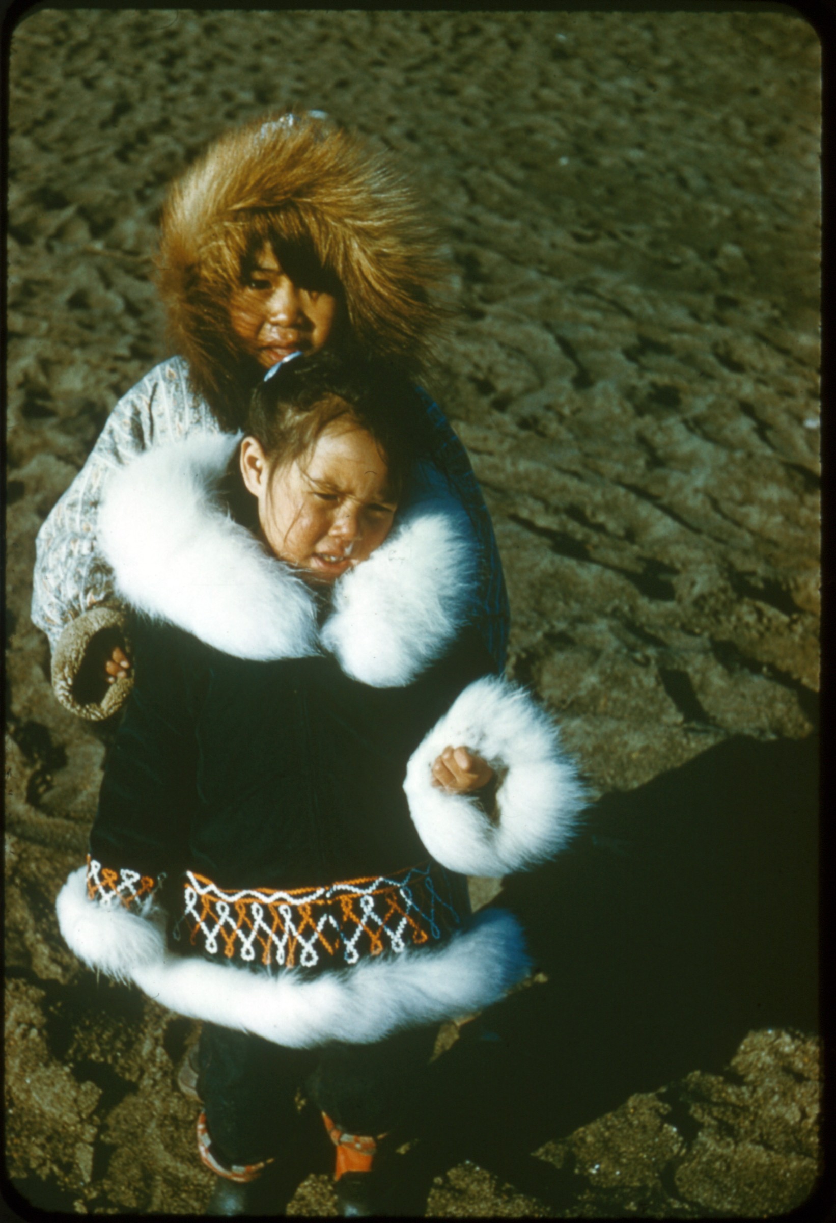
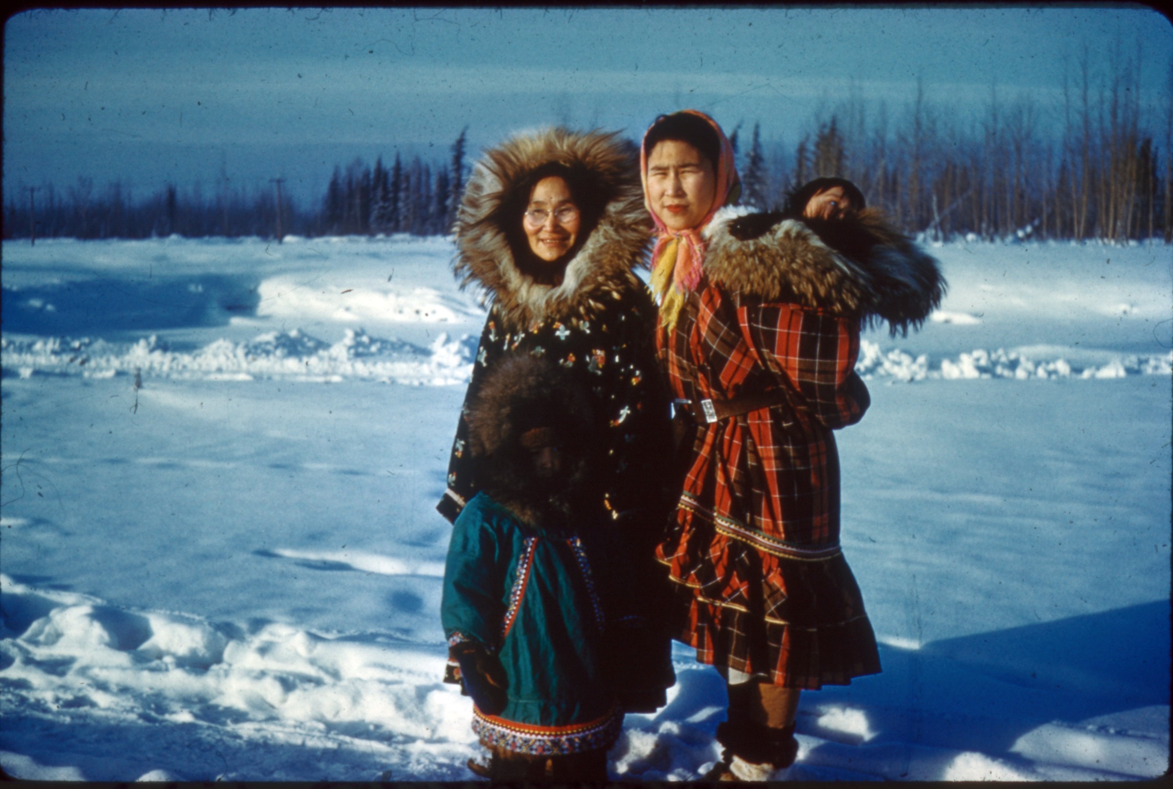
| | 172 — | [damage to Bagoy’s Florist at Fourth Avenue and B Street, Anchorage, 1964 Earthquake;
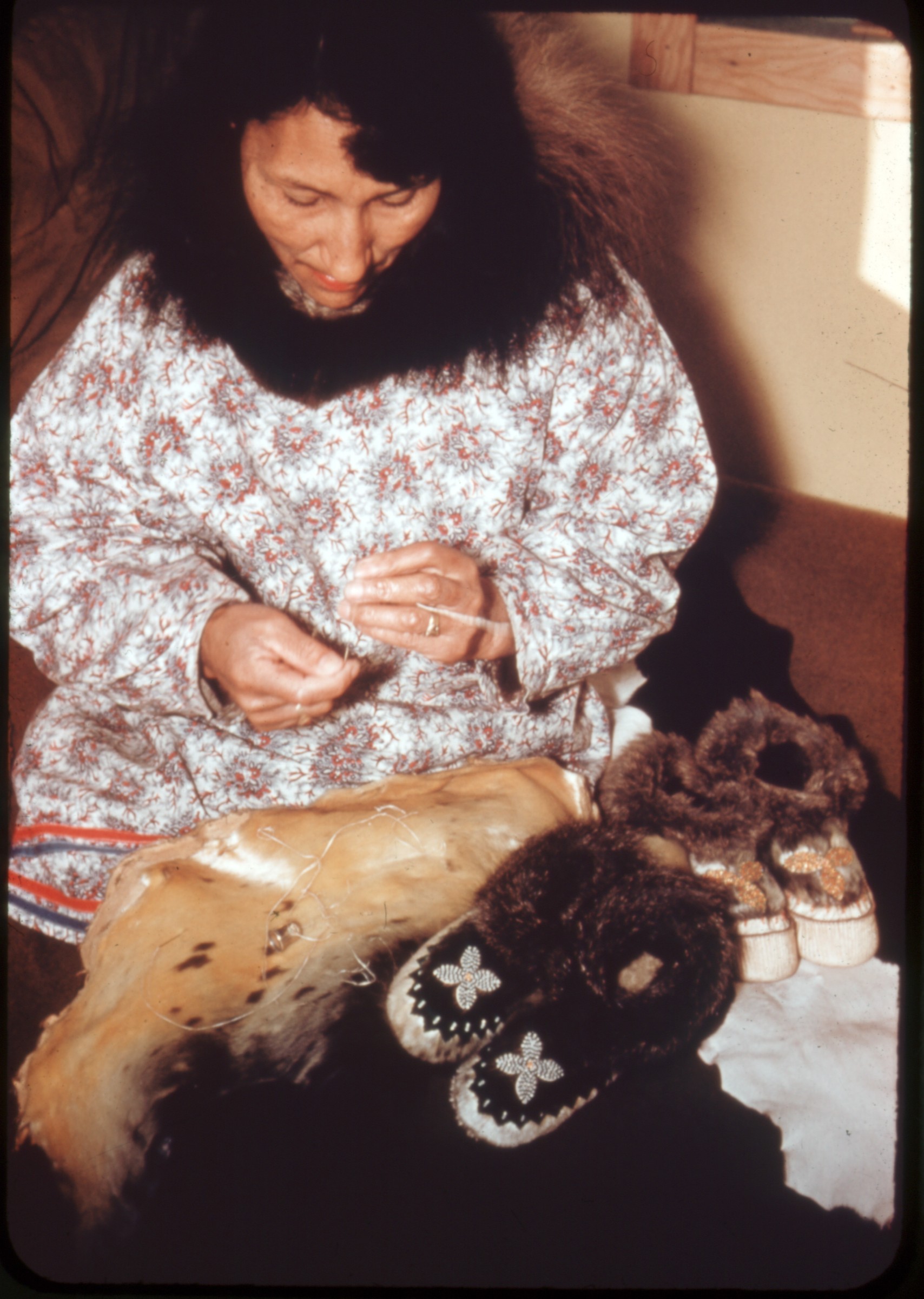
print date Apr 64] |
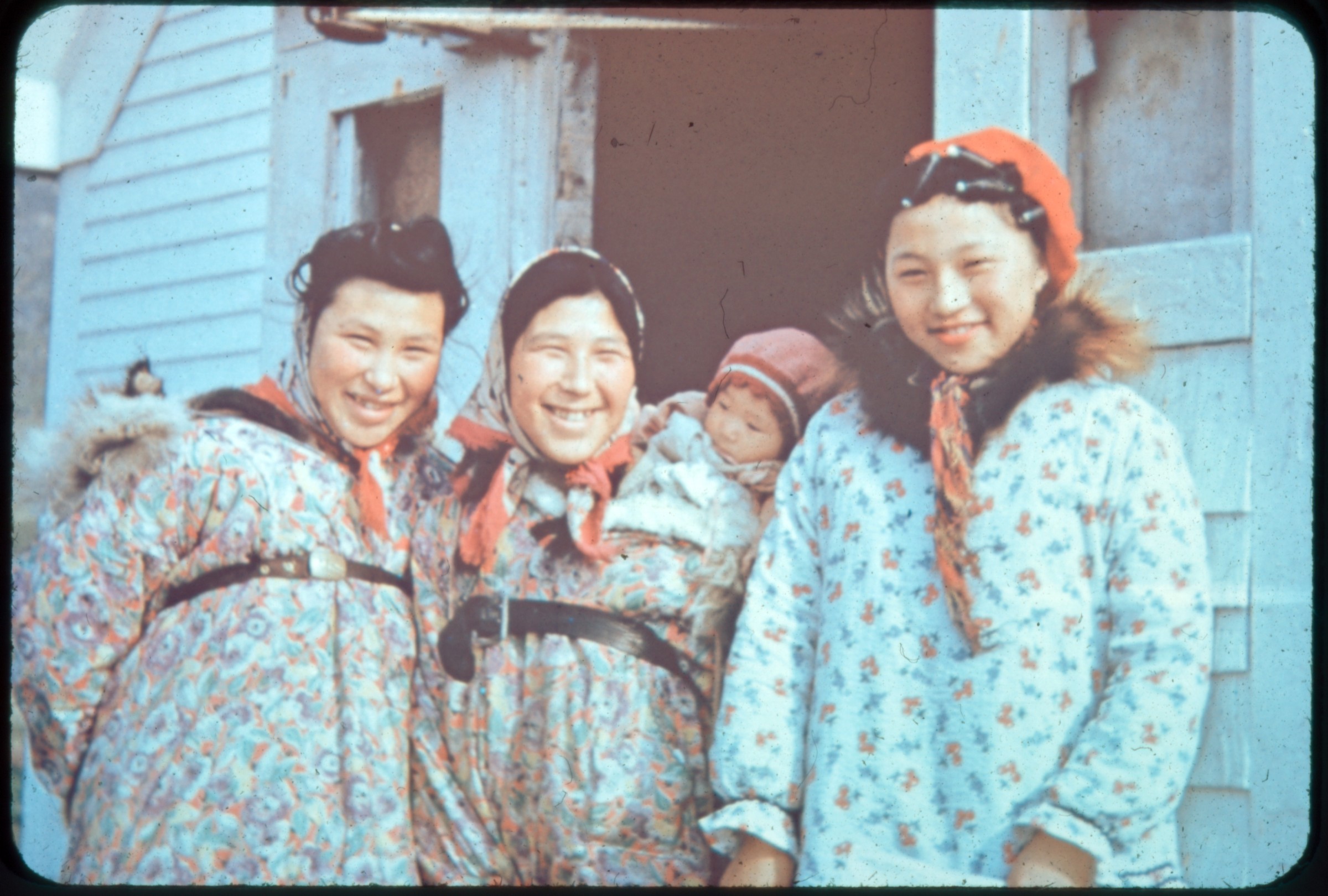
| | 173 — | [Fourth Avenue Street scene near B Street, showing damage to businesses including
Denali Theatre, Bagoy’s Florist, Green Dragon, Turf Sport Center, Harry’s Market, Anchorage,
1964 Earthquake; print date Apr 64] |
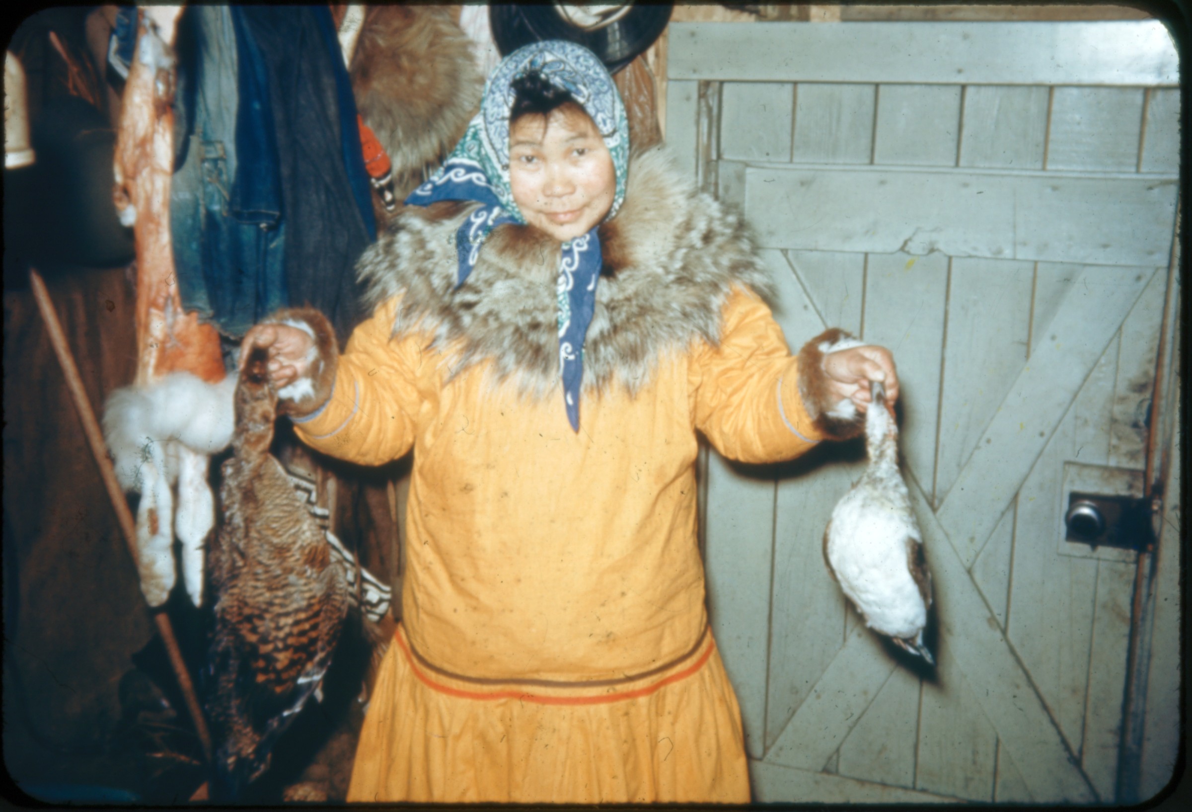
| | 174 — | [damage to Anchorage Hardware & Sporting Goods, 1964 Earthquake; print date Apr
64] |
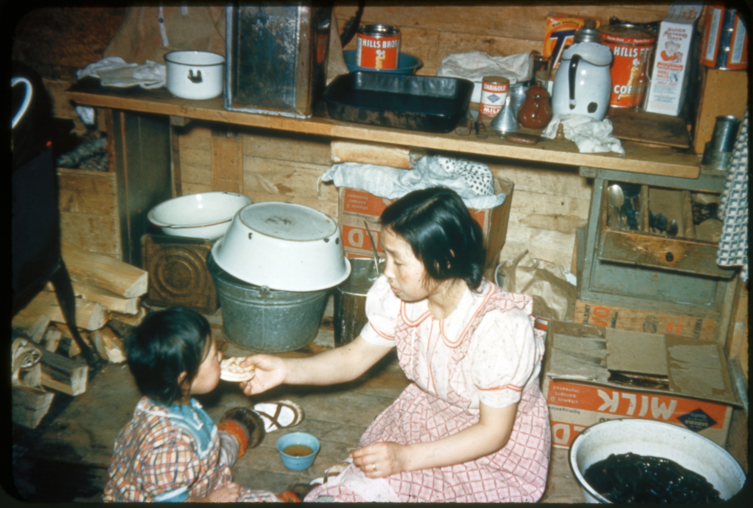
| | 175 — | [view from parking lot looking west down Fourth Avenue near B Street with damaged
businesses, hoisting equipment outside of Denali Theatre, Anchorage, 1964 Earthquake; print
date Apr 64. Cf. .161] |
| | 176 — | [Fourth Avenue street scene looking east with damaged businesses including Sedalia
Shine Parlor, Anchorage, 1964 Earthquake; print date Apr 64] |
| | 177 — | [damage to McLain’s Camera Center, Anchorage, 1964 Earthquake; print date Apr 64] |
| | 178 — | [Fourth Avenue street scene showing partial demolition of businesses, Sedalia Shine
Parlor at left, Anchorage, 1964 Earthquake; print date Apr 64] |
| | 179 — | [Fourth Avenue street scene looking west near B Street, showing damage to businesses
including Denali Theatre, Anchorage, 1964 Earthquake; print date Apr 64] |
| | 180 — | [view across Fourth Avenue near B Street, showing damage to businesses including
Denali Theatre and Bagoy’s Florist, Anchorage, 1964 Earthquake; print date Apr 64] |
| | 181 — | [damage to McLain’s Camera Center, Anchorage, 1964 Earthquake; print date Apr 64] |
| | 182 — | [Fourth Avenue street scene looking east from D Street, showing damage to businesses
including Anchorage Hardware, Northern Jewelers, Seidenverg & Kay, D & D Bar and Café,
1964 Earthquake; print date Apr 64] |
| | 183 — | 4th K [damage to Inlet Hotel on Fourth Avenue and K Street, Anchorage, 1964
Earthquake; print date Apr 64] |
| | 184 — | [view across Fourth Avenue showing damage to D & D Bar and Café, Anchorage, 1964
Earthquake; print date Apr 64] |
| | 185 — | [Fourth Avenue street scene looking west showing damage to businesses including BJ’s
Billiards, D & D Bar & Café, Pioneer Loan Co., Anchorage Westward Hotel in background, 1964
Earthquake; print date Apr 64]
|
| | 186 — | [Fourth Avenue street scene looking west near B Street, showing damage to businesses
including Denali Theatre, Anchorage Westward Hotel in background, 1964 Earthquake; print
date Apr 64] |
| | 187 — | [view across Fourth Avenue between B and C Streets, showing damage to businesses
including Sedalia Shine Parlor and Denali Theatre, Anchorage, 1964 Earthquake; print date Apr
64] |
| | 188 — | [damage to Denali Theatre at Fourth Avenue and B Street, with street sign, man
climbing into window on ladder, Anchorage, 1964 Earthquake; print date Apr 64. Cf. .169] |
| | 189 — | [street scene at intersection of Fourth Avenue and K Street showing damage to Inlet
Hotel, soldiers at barricade, Anchorage, 1964 Earthquake; print date Apr 64] |
| | 190 — | [close-up of damage to entrance of Northern Commercial Co., 722 Fourth Avenue,
Anchorage, 1964 Earthquake; print date Apr 64] |
| | 191 — | [close-up of damage at 1005 Fourth Avenue, Anchorage, 1964 Earthquake; print date
Apr 64. Cf. .166] |
| | 192 — | [Fourth Avenue street scene looking east, fresh snow on ground, signs for businesses
including Hofbrau, Alaska Treasure Shop, barricades in foreground, Anchorage, 1964
Earthquake; print date Apr 64] |
| | 193 — | [damage to Hunter Bar at Fourth Avenue and C Street, large pile of gravel in street at
right, Anchorage, 1964 Earthquake; print date Apr 64] |
| | 194a — | [view across Fourth Avenue showing damage to businesses including BJ’s Billiards, D &
D Bar & Café, Pioneer Loan Co., Anchorage, 1964 Earthquake; print date Apr 64] |
| | 194b — | [view across Fourth Avenue between B and C Streets, showing damage to businesses
including Denali Theatre, Anchorage, 1964 Earthquake; print date Apr 64] |
| | 195 — | [Fourth Avenue street scene looking west near B Street, showing damage to businesses
including Denali Theatre, Anchorage Westward Hotel in background, 1964 Earthquake; print
date Apr 64] |
| | 196 — | [view across Fourth Avenue near D Street showing damage to businesses including
Hobby Lobby, Seidenverg & Kay, Northern Jewelers, Anchorage Hardware, and McLain’s
Camera Center, Anchorage, 1964 Earthquake; print date Apr 64] |
| | 197 — | [view across Fourth Avenue between B and C Streets, showing damage to businesses
including Denali Theatre, Anchorage, 1964 Earthquake; print date Apr 64] |
| | 198 — | [damage to McKinley Apartments, Anchorage, 1964 Earthquake; print date Apr 64] |
| | 199 — | [damage to McKinley Apartments, Anchorage, 1964 Earthquake; print date Apr 64] |
| | 200 — | [damage to McKinley Apartments, Anchorage, 1964 Earthquake; print date Apr 64] |
| | 201 — | [damage to McKinley Apartments, Anchorage, 1964 Earthquake; print date Apr 64] |
| | 202 — | [damage to L Street Apartments, Anchorage, 1964 Earthquake; print date Apr 64] |
| | 203 — | [damage to L Street Apartments, Anchorage, 1964 Earthquake; print date Apr 64] |
| | 204 — | [damage to L Street Apartments, Anchorage, 1964 Earthquake; print date Apr 64] |
| | 205 — | [damage to L Street Apartments, Anchorage, 1964 Earthquake; print date Apr 64] |
| | 206 — | [damage to L Street Apartments, Anchorage, 1964 Earthquake; print date Apr 64] |
| | 207 — | [damage to Hillside Apartments, Anchorage, 1964 Earthquake; print date Apr 64] |
| | 208 — | [damage to Hillside Apartments, Anchorage, 1964 Earthquake; print date Apr 64] |
| | 209 — | [damage to Hillside Apartments, Anchorage, 1964 Earthquake; print date Apr 64] |
| | 210 — | [damage to Hillside Apartments, Anchorage, 1964 Earthquake; print date Apr 64]
|
| | 211 — | [soldiers and police officer holding rifle standing at street intersection, Anchorage, 1964
Earthquake; print date Apr 64] |
| | 212 — | [large crowd of men gathered outside Ben Franklin five-and-dime, possibly soldiers and
civil defense, Anchorage, 1964 Earthquake; print date Apr 64. Cf. .214] |
| | 213 — | [U.S. Army truck and Jeep parked in lot next to small tent, Anchorage, 1964 Earthquake;
print date Apr 64] |
| | 214 — | [large crowd of men gathered outside Ben Franklin five-and-dime, possibly soldiers and
civil defense, Anchorage, 1964 Earthquake; print date Apr 64. Cf. .212] |
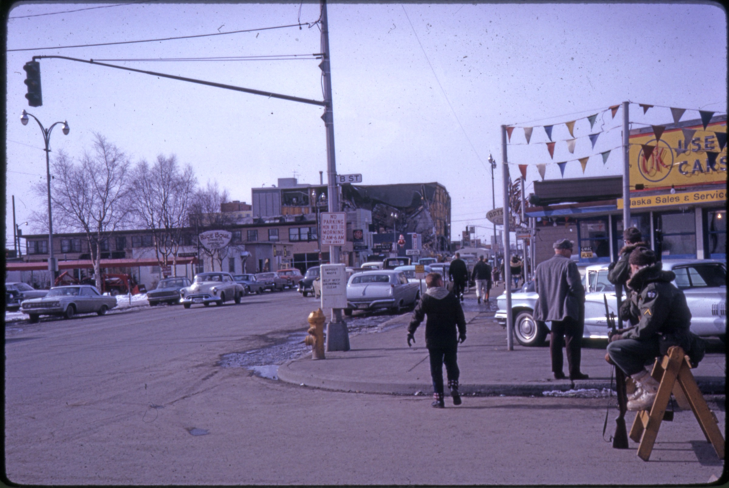
| 215 — | [street scene at intersection of B Street and Fifth Avenue, soldiers sitting on barricade
at left, sign for Rice Bowl restaurant at left, J.C. Penney parking garage in distance, Anchorage,
1964 Earthquake; print date Apr 64] |
| | 216 — | [scenic of Yukon River and mountains, building complex at right, Dawson City; print
date Aug 62] |
| | 217 — | [man, possibly Reese, wearing suit and tie standing on gravel road near signs reading
“Welcome to Dawson City the Heart of the Klondike,” “Dawson City Festival,” and “Dawson
City Ferry”; print date Aug 62] |
| | 218 — | [street scene with boardwalk, automobile, buildings, Dawson City; print date Aug 62] |
| | 219 — | [man in uniform standing outside building next to antique steam pumper fire engine,
Dawson City; print date Aug 62] |
| | 220 — | [Red Feather Saloon, Dawson City; print date Aug 62] |
| | 221 — | [dilapidated, narrow two-story building, Dawson City; print date Aug 62] |
| | 222 — | [pedestrian walking on boardwalk in front of dilapidated buildings, one with sign for
Wholesale Hardware, Dawson City; print date Aug 62. Cf. .224] |
| | 223 — | [Queen Street scene, with automobiles, Bank of Commerce at left and sternwheeler S.S.
Keno, Dawson City; print date Aug 62] |
| | 224 — | [abandoned Wholesale Hardware, Dawson City; print date Aug 62. Cf. .222] |
| | 225 — | [The American, hotel or bar, Dawson City; print date Aug 62] |
| | 226 — | [Y.O.O.P. Pioneer Hall, Dawson City; print date Aug 62] |
| | 227 — | [log cabin, Dawson City; print date Aug 62] |
| | 228 — | [K.T.M. Co., “the store that sells most everything,” Dawson City; print date Aug 62] |
| | 229 — | [dilapidated building across street from Red Feather Saloon, Dawson City; print date
Aug 62] |
| | 230 — | [Klondike Nugget & Ivory Shop, antique steam pumper fire engine parked next door,
with sign reading “The pride of Dawson City F.D. 1898,” not same as in .219, Dawson City;
print date Aug 62] |
| | 231 — | [The Palace Grand Theatre, Dawson City; print date Aug 62] |
| | 232 — | [metal storage box set into hillside, with sign reading “Old safe used in gold-rush days,”
Dawson City; print date Aug 62] |
| | 233 — | [3rd Ave Blacksmith Shop, Dawson City; print date Aug 62] |
| | 234 — | [Dawson Hardware Co., Dawson City; print date Aug 62] |
| | 235 — | [Masonic Temple, Dawson City; print date Aug 62] |
| | 236 — | [man, possibly Reese, wearing suit and tie standing in front of Robert Service’s cabun,
Dawson City; print date Aug 62] |
| | 237 — | [street scene with buildings, Dawson City; print date Aug 62]
|
| | 238 — | Stewart’s Photo Shop [commercial slide. Original caption covered by slide label.
Sternwheelers Keno and Whitehorse; no date] |
| | 239 — | [aerial view of Lake Hood, with floatplanes tied along shore, Cook Inlet in distance,
Anchorage; no date] |
| | 240 — | [Sea Airmotive, two men standing on dock next to floatplane; print date Jul 71] |
| | 241 — | [passengers lined up to board Sea Airmotive floatplane with wheels parked on tarmac;
print date Jul 71] |
| | 242 — | 1970 [three people standing outside King Salmon post office, man and woman at left
possibly Chester and Leah Peterson] |
| | 243 — | 1970 [two people standing outside King Salmon post office, man at left possibly Chester
Peterson] |
| | 244 — | 1970 [man, possibly Chester Peterson, standing next to Wien Airlines Grumman Mallard
tail number N1208 at King Salmon airport, crewman fueling airplane] |
| | 245a — | 1970 [passengers lined up to board Wien Airlines Grumman Mallard tail number
N1208 at King Salmon airport, crewman fueling airplane] |
| | 245b — | 1970 [Wien Airlines Grumman Mallard tail number N1208 parked on Marsden matting
next to Brooks River, passengers standing on beach] |
| | 246 — | [view from upper deck of railroad car of Alaska Railroad depot at Whittier, water in
background; no date] |
| | 247 — | [distant view of Buckner Building, Whittier; no date] |
| | 248 — | [hanging glacier near Whittier, Alaska Railroad tracks in foreground; no date] |
| | 249 — | [man, possibly Reese, wearing eyeglasses, trench coat and tie standing next to
interpretive marker explaining effects of 1964 earthquake on Seward Highway; no date] |
| | 250 — | [Holy Assumption of the Virgin Mary Russian Orthodox Church, Kenai; 1967?] |
| | 251 — | [woman standing next to sign reading “Russian Chapel,” Church of the Dormition,
Kenai; print date Nov 67] |
| | 252 — | Wyman’s Photo Service [commercial slide. Scenic of Eklutna Lake; no date] |
| | 253 — | Harold W. Johnson, Northern Color Film Co. [commercial slide. Bird’s eye view of freight
ships at Alaska Railroad dock, Seward; no date] |
| | 254 — | No. 248. Copper Center Lodge. Stewart’s Photo Shop [commercial slide. Copper Center
Roadhouse; no date] |
| | 255 — | 142. Hewitt’s Drug Store [commercial slide. Docks and duildings on pilings, Cordova; no
date] |
| | 256 — | Wyman’s Photo Service [commercial slide. Kotzebue waterfront in winter, with
pedestrians, boats, buildings; no date] |
| | 257 — | [sign on building reading “Barns where mules of the U.S. Army were stabled during
period 1897-1911,” Fort Egbert, Eagle; print date Nov 74] |
| | 258 — | 176A. Hewitt’s Drug [commercial slide. Four automobiles on old Glenn Highway passing
gas station, Chugiak; no date] |
| | 259 — | Oct. 1970 [Cessna floatplane tail number N1970U on Susitna Flats, Mt. Susitna in
background] |
| | 260 — | Oct. 1970 [wooden skiff next to duck shack, Susitna Flats] |
| | 261 — | Oct. 1970 [view from porch of duck shack from Susitna Flats to Cook Inlet, with two
other shacks on stilts, boat parked on flats. Cf. 263]
|
| | 262 — | [man wearing hip boots and eyeglasses, possibly Reese, standing on porch of duck
shack on Susitna Flats] |
| | 263 — | Oct. 1970 [view of duck shacks on Susitna Flats, taken from Reese’s shack in opposite
direction from view in .261] |
| | 264 — | Oct. 1970 [man holding rifle posed next to duck shack on Susitna Flats] |
| | 265 — | [snowcat tracked vehicle in wooded area in winter; print date Dec 61] |
| | 266 — | [two men saddling horse next to log cabin; print date Sep 61] |
| | 267 — | [horse wearing wooden saddle tied to tree; print date Sep 61] |
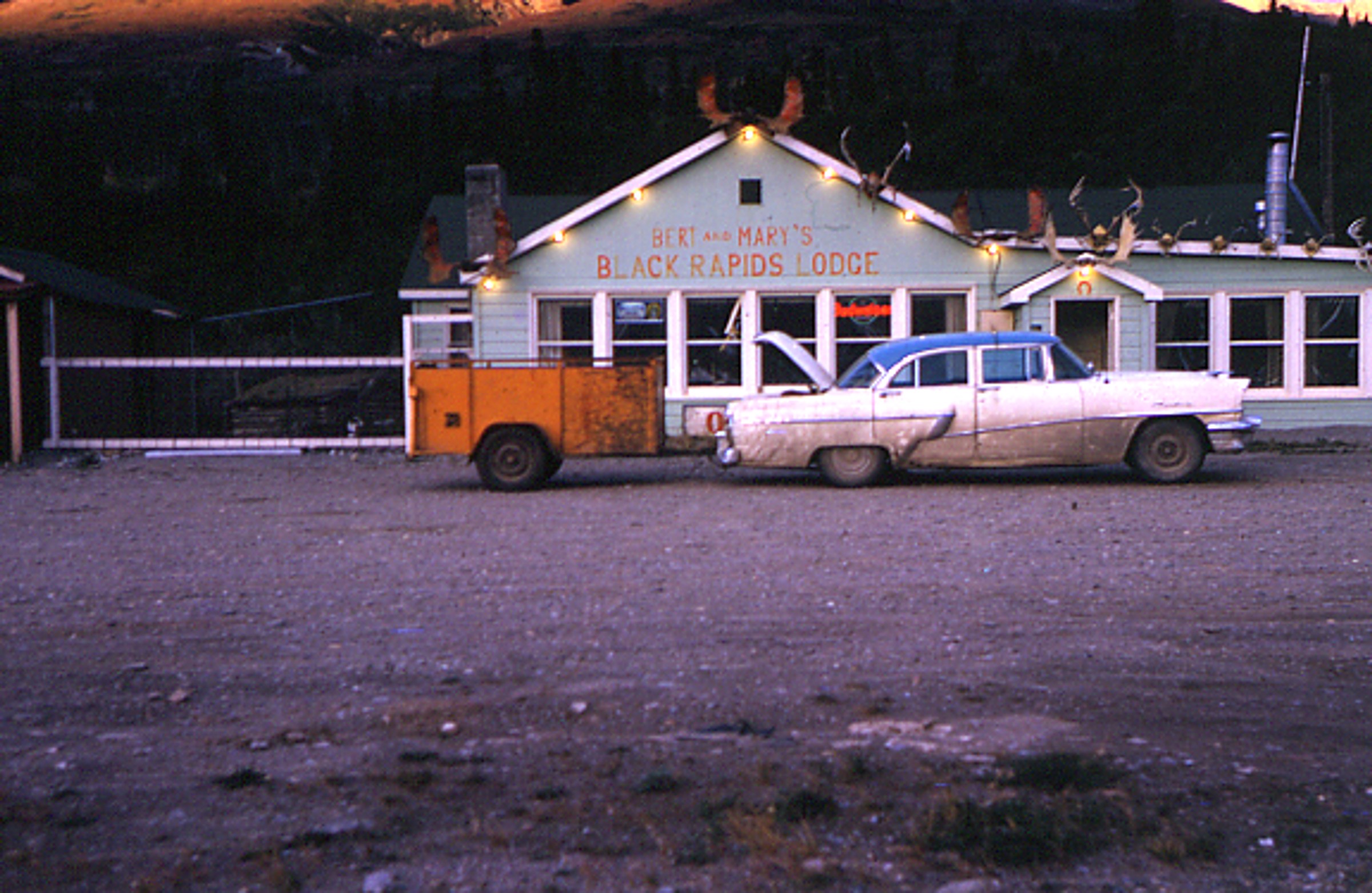
| 268 — | [two automobiles parked outside Rapids Hunting Lodge, also known as Black Rapids
Roadhouse; print date Sep 61] |
| 269 — | [two automobiles parked outside Rapids Hunting Lodge, also known as Black Rapids
Roadhouse, showing log structure and later addition with wood siding, antlers and sled frames
on roof; print date Sep 61] |
| 270 — | [automobile pulling small trailer parked outside addition to Rapids Hunting Lodge (or
Black Rapids Roadhouse) with sign for “Bert and Mary’s Black Rapids Lodge”; print date Sep
61] |
| | 271 — | [three men standing outside building with sign for “Butcher’s Camp, hunting & fishing,
boats guides weasel trips, game brought to road, photo parties groceries,” antlers on roof,
Volkswagen Beetle parked at left, Tangle Lakes; print date Sep 61] |
| | 272 — | [automobiles parked near small wooden building with sign “Hunters stop here Alaska
Dept. of Fish & Game,” other buildings in background, unidentified location; print date Sep 61] |
| | 273 — | [large 48-star flag with extra star for Alaska statehood hanging from federal building on
Fourth Avenue in Anchorage, truck with tarped trailer reading “Alaska State or Bust” parked in
front, automobiles passing by; print date Jul 58] |
| | 274 — | [sailor in uniform walking past wood piled for statehood bonfire, park strip, Anchorage;
print date Jul 58] |
| | 275 — | Apr 64 [winter street scene at Third Avenue and H Street in Anchorage, with Elks Lodge
at left, Anchorage Westward Hotel in background, possibly showing earthquake damage to
hotel] |
| | 276 — | [mouth of Ship Creek at low tide, with docks, boats, buildings at right with sign for
Miller-Dalton Co.; late 1950s?] |
| | 277 — | [musher wearing bib #16 leading dog team past spectators down Cordova Hill,
Anchorage Fur Rendezvous; print date Mar 62] |
| | 278 — | [distant view of musher leading dog team down Cordova Hill, spectators and buildings
in background, Anchorage Fur Rendezvous; print date Mar 62] |
| | 279 — | [musher wearing bib #16 leading dog team down street at bottom of Cordova Hill,
Anchorage Fur Rendezvous; print date Mar 62] |
| | 280 — | [musher wearing bib #5 leading dog team past spectators, sled sponsored by Alaska
Airlines, Anchorage Fur Rendezvous; print date Mar 62] |
| | 281 — | [winter street scene, S & F Foodland store at right, 3703 Spenard Road, Anchorage;
1962?] |
| | 282 — | [street scene with automobiles passing Food Giant grocery store, 235 W Ninth Avenue,
Anchorage; after 1969. Cf. .294] |
| | 283 — | [interior of grocery store, possibly C Street Foodland, with clerk stocking produce; 1957]
|
| | 284 — | [interior of grocery store, possibly C Street Foodland, view down aisle with boxed and
canned goods; 1957] |
| | 285 — | [interior of grocery store, possibly C Street Foodland, with grocery cart full of potatoes
produce area and cold cases at left; 1957] |
| | 286 — | Reese [interior of grocery store, possibly C Street Foodland, with two men in produce
area, grocery carts full of tomatoes; 1957] |
| | 287 — | Reese [interior of grocery store, possibly C Street Foodland, with man wearing
eyeglasses stocking dairy case; 1957] |
| | 288 — | [interior of grocery store, possibly C Street Foodland, with people standing around large
cake, store opening? 1957] |
| | 289 — | [street scene at Ninth Avenue and C Street, with exterior of building, sign for G & G
Liquor Store, Foodland windows at right, Anchorage; 1957. Cf. .295] |
| | 290 — | Reese [automobiles parked in lot outside C Street Foodland Drive-In Market; 1957] |
| | 291 — | [interior of grocery store, possibly C Street Foodland, with checkout registers; 1957] |
| | 292 — | [interior of grocery store, possibly C Street Foodland, view down aisle with paper
products and candy; 1957] |
| | 293 — | [interior of grocery store, possibly C Street Foodland, view down aisle with clerk
stocking canned goods; 1957] |
| | 294 — | [parking lot and Food Giant grocery store, Anchorage; after 1969. Cf. .282] |
| | 295 — | [automobiles parked outside building with signs for C Street Foodland, G and G Liquors;
1962? Cf. .289] |
| | 296 — | [musher wearing bib #6 and handlers getting dog team ready on Fourth Avenue in front
of Woolworth’s, Anchorage Fur Rendezvous; print date Feb 64] |
| | 297 — | [musher wearing bib #3 leading dog team down Fourth Avenue past spectators in
bleachers, Anchorage All-America City banner hanging over street, signs for businesses
including National Bank of Alaska, The Hub Clothing, Kennedy Hardware, Anchorage Fur
Rendezvous; print date Feb 64] |
| | 298 — | Cecil Rhode, Alaska Wildlife Films [commercial slide. Brown bears and seagulls in river
bed fishing for salmon; no date] |
| | 299 — | Cecil Rhode, Alaska Wildlife Films [commercial slide. Brown bear; no date] |
| | 300 — | Cecil Rhode, Alaska Wildlife Films [commercial slide. Brown bear carrying salmon; no
date] |
| | 301 — | Cecil Rhode, Alaska Wildlife Films [commercial slide. Brown bear with three cubs; no
date] |
| | 302 — | Harold W. Johnson, Northern Color Film Co. [commercial slide. Brown bears and
seagulls in river fishing for salmon; no date] |
| | 303 — | Cecil Rhode, Alaska Wildlife Films [commercial slide. Dall sheep; no date] |
| | 304 — | Cecil Rhode, Alaska Wildlife Films [commercial slide. Musk oxen; no date] |
| 305 — | Hewitt’s Drug [commercial slide. two young children wearing mukluks and parkas with
fur trim standing outdoors; no date] |
| 306 — | 1014 [commercial slide. Woman wearing print parka with fur trim working thread in her
fingers, two pairs of completed moccasins in front of her; no date. At AFN 2015, tentatively
identified as Julia Greene of Kotzebue]
|
| 307 — | Stewart’s Photo Shop [commercial slide. Three women wearing print parkas with fur
trim posed outdoors, woman in center carrying baby; no date. At AFN 2015, identified as (left
to right): Cecilia Amarok Smith, Margaret Olanna holding Howard Nunooruk, and Ruth
Koweluk Koenig at Wales] |
| 308 — | Griffin’s [commercial slide. Two young children wearing parkas with fur trim standing
outdoors, Barrow? No date] |
| 309 — | Griffin’s [commercial slide. Woman wearing eyeglasses, woman carrying baby, and
young child posed outdoors, all wearing parkas with fur trim; no date. At AFN 2015, identified
as Edith Tegoseak at left, and Polly Tegoseak at right, location as Fairbanks, date 1950-1960] |
| 310 — | 541 [commercial slide. Woman wearing headscarf and print parka with fur trim
standing indoors holding two dead birds; no date. At AFN 2016, location identified as
Chefornak, woman tentatively identified as Mrs. Tirchik] |
| | 311 — | [commercial slide. Woman in fur-trimmed parka standing outdoors holding dried
salmon, snow on ground and house behind, possibly Bethel area. Same as B1989.016.1870.2a] |
| 312 — | 536. Hewitt’s Drug [commercial slide. Woman and child sitting on floor of house,
woman feeding child, possibly Pilot Bread, firewood, pots and pans, and canned goods visible;
no date. At AFN 2016, contents of basin at right identified as blackfish] |
| | 313 — | [two men in field harvesting potatoes, tractor at right, Matanuska Valley; no date] |
| | 314 — | [field after harvesting, with sacks of potatoes in rows, Matanuska Valley; no date] |
| | 315 — | Stewart’s Photo Shop [commercial slide. Matanuska Valley farm, with hay stacks in field
in foreground, barn and homestead in background; no date] |
| | 316 — | Hewitt’s Drug [dragline excavator at mining operation, unidentified location; no date] |
| | 317 — | [autumn view down Seward Highway and Alaska Railroad tracks along Turnagain Arm;
print date Nov 74] |
| | 318 — | [sand bags piled up along Seward Highway near Portage after the 1964 earthquake;
print date Jul 64] |
| | 319 — | Alaskan Photography by Everett J. Wilde [commercial slide. Two log cabins along bend
in river, mountains in background, Tok; no date] |
| | 320 — | Stewart’s Photo Shop [commercial slide. Scenic of Kenai River, automobile on road at
right; no date] |
| | 321 — | Stewart’s Photo Shop [commercial slide. Autumn view down unpaved road through fall
foliage, Kenai Highway? no date] |
| | 322 — | Stewart’s Photo Shop [commercial slide. Scenic of Glenn Highway, with Lion’s Head in
center; no date] |
| | 323 — | Stewart’s Photo Shop [commercial slide. View down Glenn Highway near Eureka,
buildings on left, mountain in distance; no date] |
| | 324 — | Wyman’s Photo Service [commercial slide. View down Richardson Highway to bridge,
possibly Tsina River, hanging glacier in background; no date]
Guide updated: December 28, 2017 |