| | 1 — | Ice jam, Susitna Crossing, 5/15/19 |
| | 2 — | North Channel, Susitna Crossing, May 15, 1919. Ice jam [same as .1] |
| | 3 — | Marine Ways (Alaska Railroad Shipyard), Nenana MP 411.7. The big boat in the middle is
the Nenana, the one to the left is the “Alice,” the smaller boats are the Matanuska and the Fish
& Wildlife patrol, plus barges. February 22, 1939 |
| | 4 — | Nenana MP 411.7 as it was February 22, 1939 |
| | 5 — | Northbound doubleheader passenger on “The Loop” MP 98.3. April 14, 1941 |
| | 6 — | June 13-14, 1943. Fishing trip to Bear Lake 8 miles from Chulitna. Nils Bysheim, Jack
Hansen, Carl Newcomb, A.C. Moorehead. Ken Tozer photographer |
| | 7 — | Close up of Bartlett Glacier, Loop area MP 47+ August 15, 1944. White streak in boulders
is quartz. |
| | 8 — | Bartlett Glacier, Loop area MP 47+ August 15, 1944 |
| | 9 — | Ski jump near Alaska Native Service Hospital, Anchorage. March 3, 1946 |
| | 10 — | Honolulu Bridge (MP 287.7) under construction. April 21, 1946 |
| | 11 — | Landing weather ob. outfit, Fire Island. Dec. 19, ’47 [boat and barge on shore] |
| | 12 — | Fire Island Weather Observation project [man standing next to bulldozer] |
| | 13 — | Unloading barge, Fire Island. Dec. 19, 1947 |
| | 14 — | Landing weather ob. outfit, Fire Island. Dec. 19, 1947 [workers offloading barge] |
| | 15 — | Flat ground near west point Fire Island. Dec. 19, 1947 |
| | 16 — | Landing weather ob. outfit, Fire Island. Dec. 19, 1947 [aerial of barge and ship on shore] |
| | 17 — | [man standing next to bulldozer parked near barge] |
| | 18 — | [similar to .17] |
| | 19 — | [man standing next to bulldozer, shoreline at right, small building in distance at left] |
| | 20 — | West Point spit, Fire Island, looking towards Turnagain Arm [aerial] |
| | 21 — | Fire Island looking east. Dec. 19, 1947 [aerial] |
| | 22 — | West Point spit, Fire Island, looking east. Dec. 19, 1947 [aerial] |
| | 23 — | Fire Island looking east, looking northeast [aerial] |
| | 24 — | [aerial of barge and ship on shore] |
| | 25 — | [aerial of Fire Island shoreline, showing driftwood] |
| | 26 — | [aerial of Fire Island, boat and barge on far side of spit] |
| | 27 — | Br. 434.3, 5 14’ spans, 1948 construction. “Spike killed ties turned over in 1954.” “Shims
under tie plates.” [man standing on section of track, small creek in foreground] |
| | 28 — | Talkeetna Bridge MP 226.2, moose between ties. A very common sight. January 22, 1949 |
| | 29 — | Lowell Creek Falls, Seward, Alaska, MP 0. September 6, 1951
|
| | 30 — | Healy Bridge MP 2, Suntrana Branch. March 30, 1952. Falsework piling supporting
damaged bridge, repairs made by B & B-5 |
| | 31 — | Healy Bridge MP 2, Suntrana Branch. Falsework removed. Still laying under bridge.
Repairs made to damage by B & B # 5, May 8, 1952 |
| | 32 — | Bridge steel to be sandblasted and painted. Matanuska Bridge MP 147.5, a B & B-5
project. August 8, 1952 |
| | 33 — | B & B-5 outfit at Matanuska Bridge MP 147.5. Lake George breakup. Note debris that
comes down Knik River. River raised 8 ½’ above normal. August 8, 1952 |
| | 34 — | Lake George breakup at Matanuska Bridge MP 147.5. John Millick standing on 3’ dia.
cottonwood tree that came down Knik River during breakup. August 8, 1952 |
| | 35 — | A 3’ cottonwood tree that came down Knik River during Lake George breakup (one of the
wonders of the world). Matanuska Bridge MP 147.5. August 8, 1952 |
| | 36 — | Debris coming down Knik River during Lake George breakup. August 8, 1952 |
| | 37 — | Matanuska Bridge 147.8. 2 new 80 ft. spans connecting to old spans. B & B-5 project.
April 14, 1955 |
| | 38 — | Matanuska Bridge looking south. 2 80’ girders spans butts two overhead spans (MP 146)
erected by B & B-#5. April 14, 1955
[1964 Alaska Earthquake] |
| | 39 — | From dike at mouth of Lowell Creek [damage to Seward yard] |
| | 40 — | [Damage at Seward yard, with burned tanks] |
| 41 — | [Damage at Seward yard, with torn track] |
| | 42 — | [Damage at Seward yard, with track near tanks] |
| | 43 — | [Damage at Seward yard, with toppled cars, helicopter flying above] |
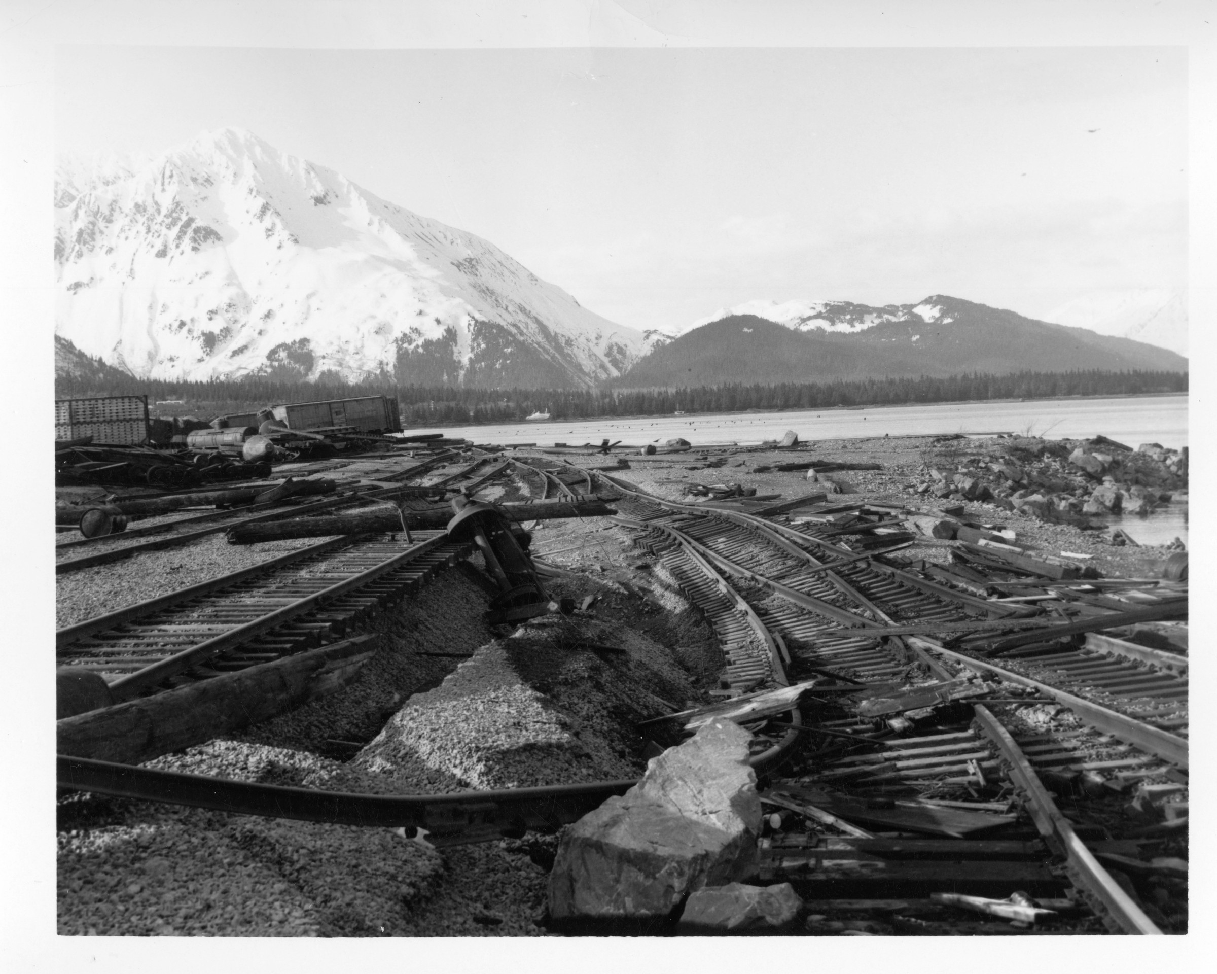
| 44 — | [Damage at Seward yard, with boats and debris piled near track] |
| | 45 — | Face of Berth 2 |
| | 46 — | Transit shed and office on Berth 2 |
| | 47 — | 3.3 [damage to bridge at MP 3.3] |
| | 48 — | Q, Bridges, 1, MP 3.3 side view by Bjerke [reverse image of .47] |
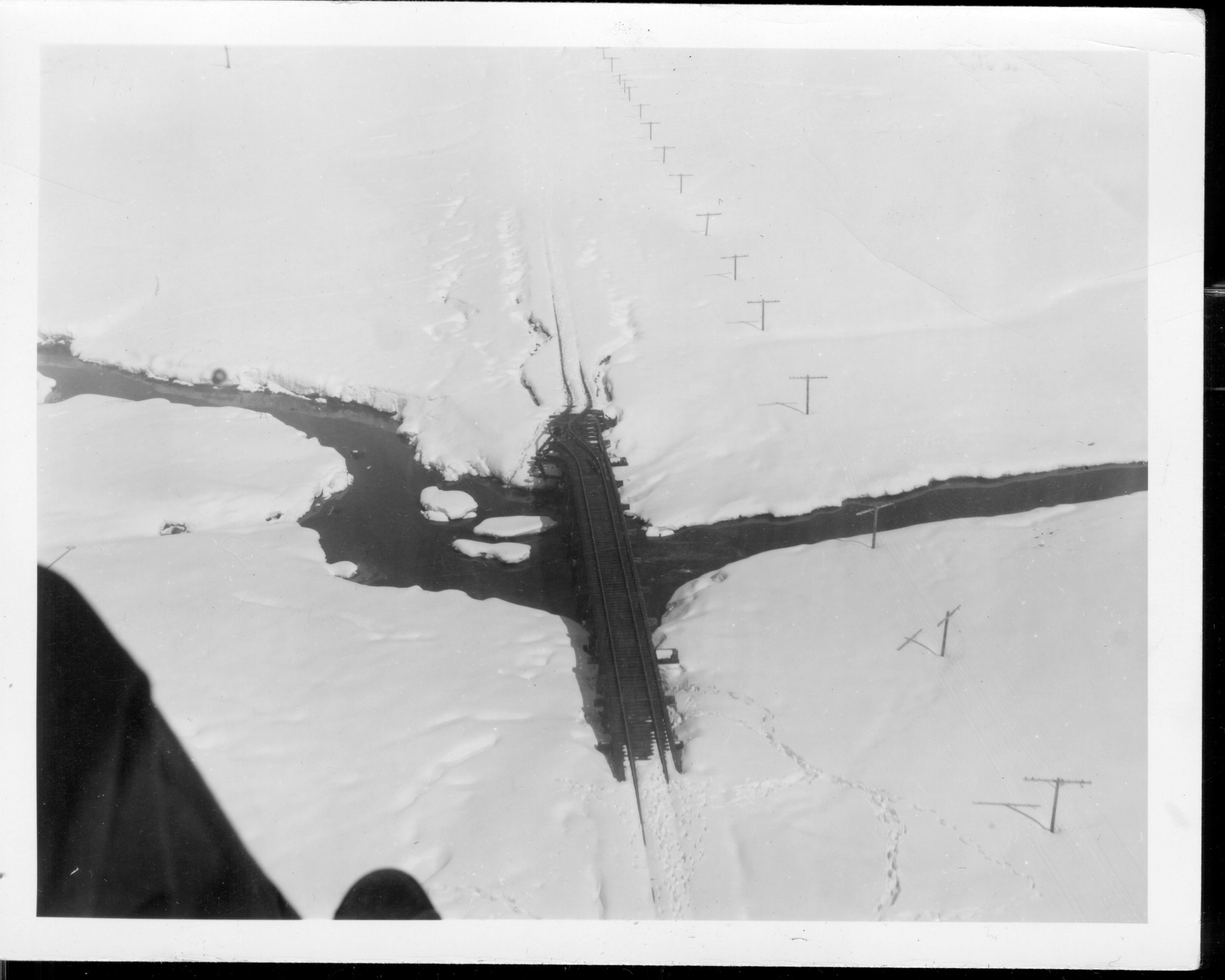
| | 49 — | Kenai Lake slide, mile 21.4 [damaged track; cf. BL1979.002.5166] |
| | 50 — | Q, Bridges, 28 [warped track] |
| | 51 — | Br. No. 34.5 [view down track to uplifted bridge] |
| | 52 — | Br. No. 34.5 [side view of uplifted bridge] |
| | 53 — | [side view of uplifted bridge] |
| | 54 — | Looking south from Br. No. 34.4 [warped track] |
| | 55 — | Q, Bridges, 11, MP 34.7 side view. By H. Bjerke 1964 [bowed bridge] |
| | 56 — | 34.7 [bowed bridge] |
| | 57 — | 34.8 reversed [bowed bridge] |
| | 58 — | Br. No. 34.8 [view down tracks over bowed bridge] |
| | 59 — | Looking south from milepost 35 [aerial] |
| | 60 — | Br. No. 37.0 [warped track] |
| | 61 — | Br. No. 37.3 [warped track] |
| | 62 — | Br. No. 37.3 (looking north) [aerial] |
| | 63 — | 41.6 [piling underneath bridge] |
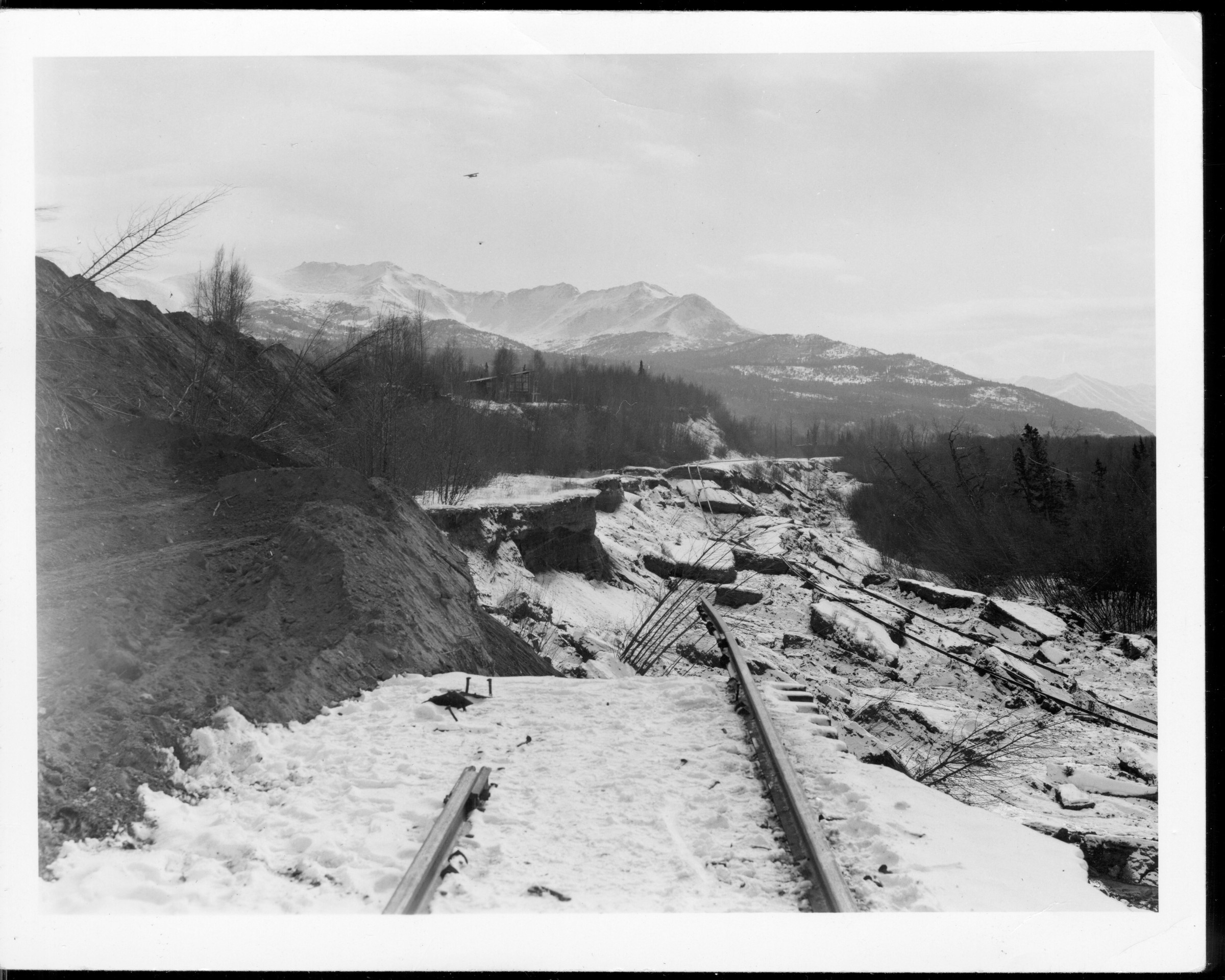
| | 64 — | 58.7 [view down snowy track to helicopter on ground, man standing at left] |
| 65 — | 58.7 [aerial]
|
| | 66 — | Q, Bridges, 22 MP 61.5 aerial view looking south. By H. Bjerke 1964 |
| | 67 — | Br. No. 61.9 [view down warped track to helicopter on ground] |
| | 68 — | Q, Bridges, 25 MP 62.3 aerial view looking north. By H. Bjerke 1964 |
| | 69 — | Br. No. 63.0 [view down warped track to helicopter on ground] |
| | 70 — | Br. No. 63.4 (looking south) [warped track] |
| | 71 — | Br. No. 63.4 [bowed bridge] |
| | 72 — | Br. No. 63.4 (looking south from north end of bridge) [warped track] |
| | 73 — | Br. No. 63.5 [view down track to bowed bridge, helicopter at left, man kneeling at right] |
| | 74 — | Wheel Shop, Anchorage [damage to Anchorage yard] |
| | 75 — | On-track equipment storage bldg., Anchorage [damage to Anchorage yard] |
| | 76 — | [warped track on short metal bridge, unidentified location] |
| | 77 — | [man standing near warped track on water crossing, unidentified location] |
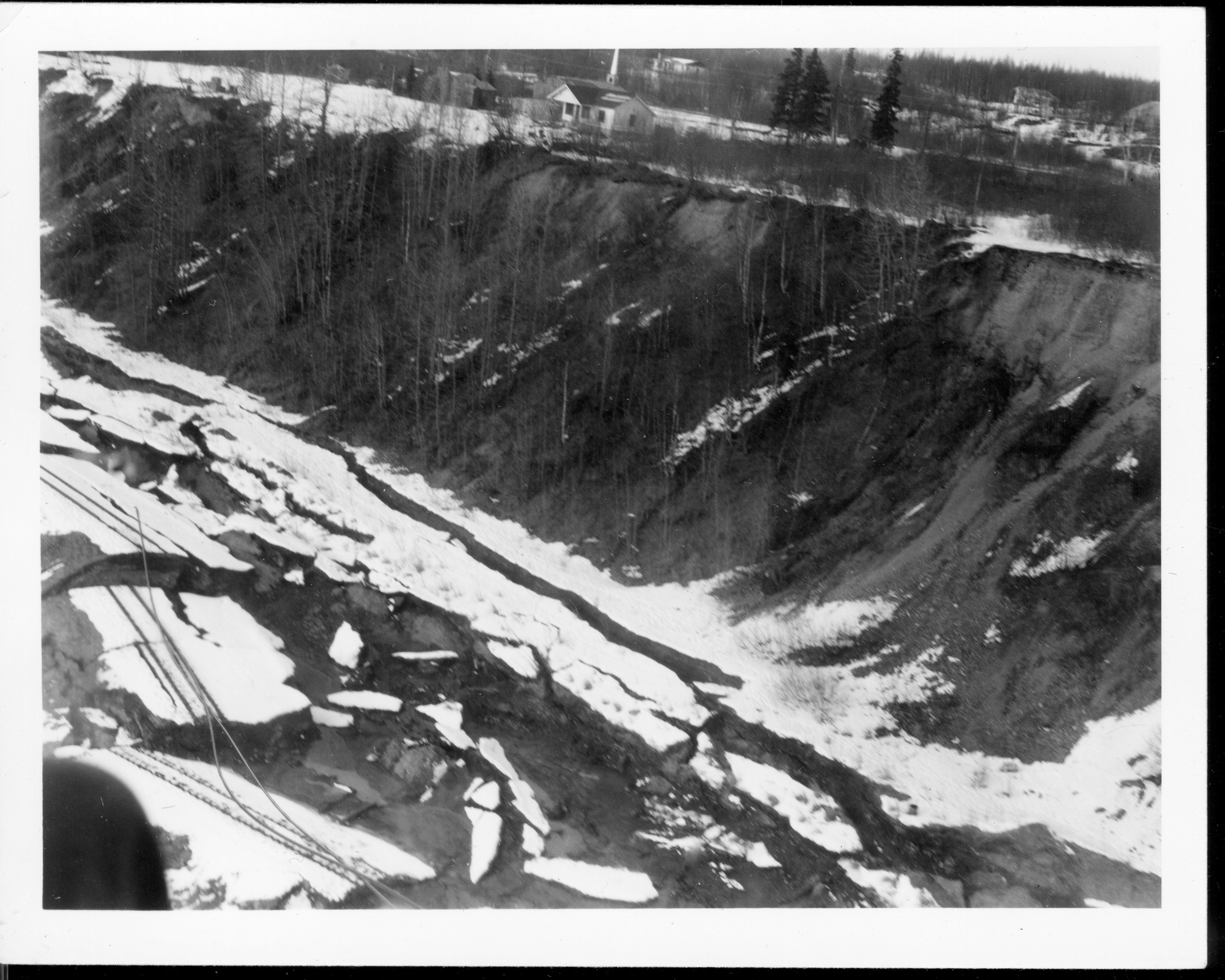
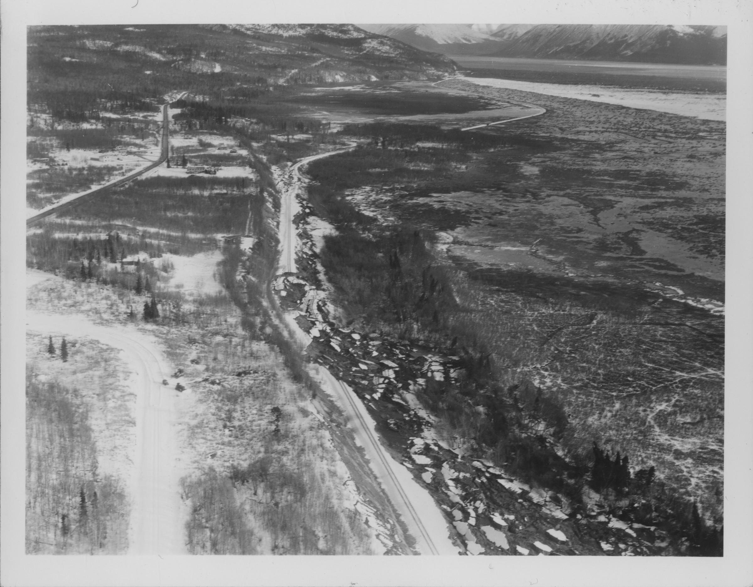
| | 78 — | [landslides along route, unidentified location] |
| 79 — | [track destroyed in landslide, Potter Hill] |
| | 80 — | [landslide area, Potter Hill] |
| | 81 — | [aerial of track running along icy waterway, unidentified location] |
| 82 — | [aerial of track in landslide area, Potter Hill?] |
| | 83 — | [aerial of track in landslide area, buildings on bluff above tracks, Potter Hill?] |
| | 84 — | [aerial of landslides along route, unidentified location] |
| | 85 — | [aerial of track in landslide area, Potter Hill?] |
| | 86 — | [aerial of track in landslide area, Potter Hill?] |
| 87 — | [aerial of track in landslide area, Seward Highway and Potter Hill?] |
| | 88 — | [aerial of track in landslide area, Potter Hill?] |
| | 89 — | [aerial of track in landslide area, buildings on bluff above tracks, Potter Hill?] |
| | 90 — | [aerial of track in landslide area, buildings on bluff above tracks, Potter Hill?] |
| | 91 — | [aerial of track in landslide area, buildings on bluff above tracks, Potter Hill?] |
| | 92 — | [aerial of track in landslide area, buildings on bluff above tracks, Potter Hill?] |
| | 93 — | [aerial of cars on track, possibly near Portage] |
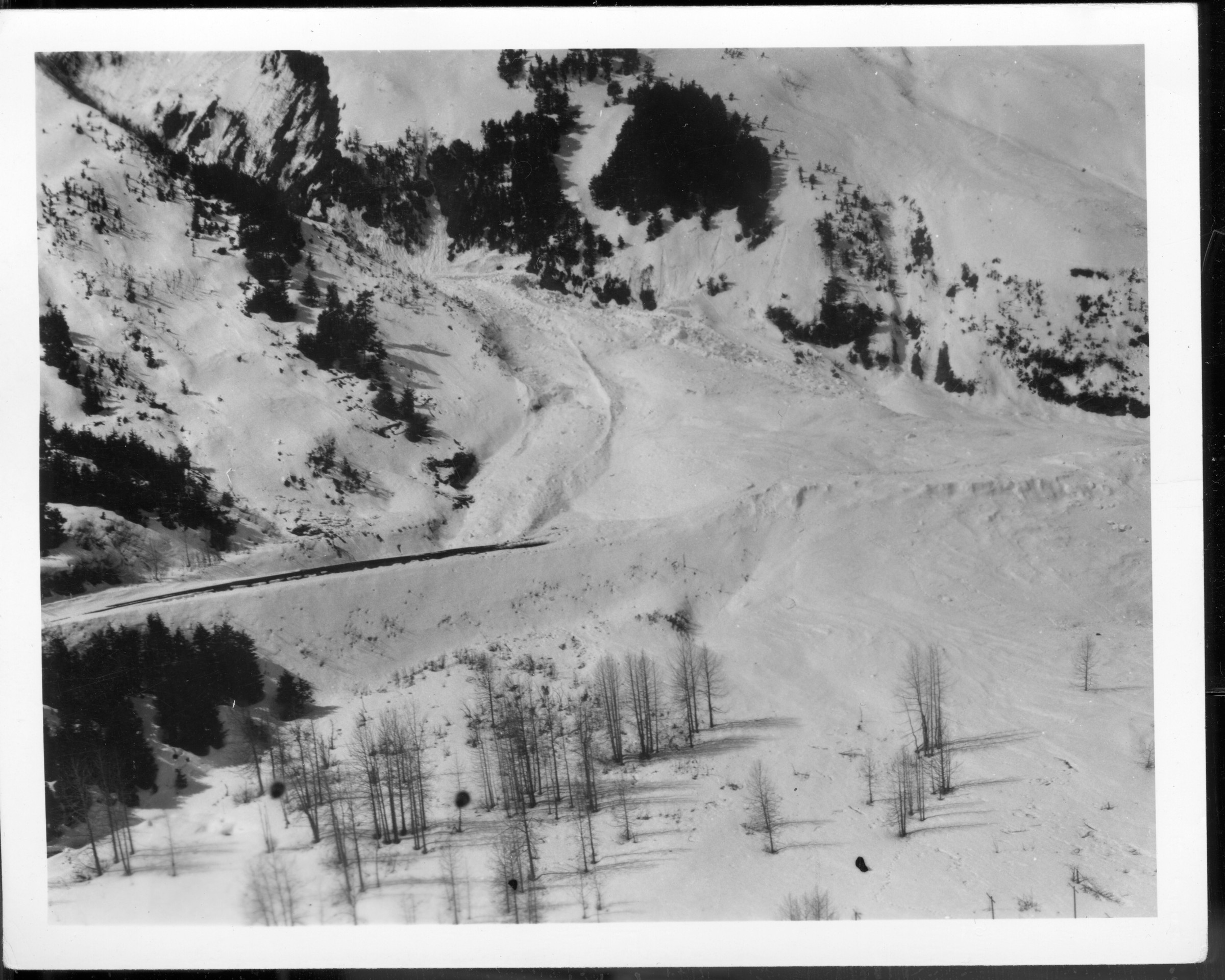
| 94 — | [aerial of snow slide] |
| | 95 — | Highway bridge, Portage 1964 [collapsed bridge] |
| | 96 — | Highway bridge, Portage 1964 [collapsed bridge] |
| | 97 — | Seward waterfront, 1965 [repairs to shoreline] |
| | 98 — | Seward waterfront 1964-65 [damaged cars in foreground, view across water to mountains]
|
| | 99 — | Moody slip MP 353 8/17 to 8/21/67. Gravel for track taken from this bank while track
was moving. H. Bradford [has neg] |
| | 100 — | Moody slip, shows hill sliding, see cracks in ground. Photo taken 8/17 - 8/21/67 H.
Bradford [has neg] |
| | 101 — | Moody slip MP 353 8/17 - 8/21/67. Extra gang repairing track, track keeps moving
downhill. At time this photo was taken track was moving about one inch an hour. H. Bradford
[has neg] |
| | 102 — | Moody slip MP 353. Shows how hill slips just below track. 8/17 - 8/21/67 H. Bradford
[has neg] |
| | 103 — | Moody slip MP 353 8/17 - 8/21/67. Shows how gravel has moved down piling, note
cracks in ground in left of photo. H. Bradford. Ex. gang in background, B & B replacing a drain
culvert. L. Voigt. [has neg]
|
| | 104 — | L. Voigt? Parks & Archie [two crewmen working on bank, one holding shovel, 1967
Moody slip? Has neg] |
| | 105 — | Moody slip MP 353. Ex gang lining track over. Foreman Huntz in foreground. 8/17 -
8/21/67 H. Bradford [has neg] |
| | 106 — | Bridge 64.7. Pier 5 [arrow]. 7/23/68 [side view of bridge at Twentymile River]
|
| | 107 — | Track insulation, airport spur, 5-25-76 [crew working on track project] |
| | 108 — | Airport track spur insulation section, 5-25-76 |
| | 109 — | Track insulation, airport spur, pulling rail w/loader, 5-25-76 |
| | 110 — | Track insulation MP 439, removing track, 5-25-76 |
| | 111 — | Track insulation, airport spur, rail pulled, 5-25-76 |
| | 112 — | Insulated track, airport spur, pulling ties, 5-25-76 |
| | 113 — | Track insulation MP 439, removing ties, 5-26-76 |
| | 114 — | Track insulation MP 439, grading roadbed, 5-26-76 |
| | 115 — | Track insulation, airport spur, drilling hole for thermistors, 5-25-76 |
| | 116 — | Track insulation, airport spur, drilling hole for thermistors, 5-25-76 |
| | 117 — | Airport spur track insulation, grading for insulation board, 5-25-76 |
| | 118 — | Insulated track, Fairbanks section, grade prepared for insulation, airport spur, 5-25-76 |
| | 119 — | Track insulation, airport spur, laying out insulation board, 5-25-76 |
| | 120 — | Track insulation MP 439, laying out insulation board, 5-26-76 |
| | 121 — | Track insulation airport spur, laying out insulation board, 5-25-76 |
| | 122 — | Track insulation MP 439, drilling for thermistor string and backfilling over insulation
board, 5-27-76 |
| | 123 — | Track insulation board, 5-25-76 |
| | 124 — | Track insulation MP 439, backfilling over insulation board, 5-27-76 |
| | 125 — | Track insulation MP 439, replacing track, 5-26-76 |
| | 126 — | Track insulation MP 439, replacing track, 5-27-76 |
| | 127 — | Track insulation MP 439, shim spots, 5-27-76 |
| | 128 — | Track insulation MP 439, finished job, 5-27-76 |
| | 129 — | [Alaska Railroad engine 1512 pulling car 1517, possibly near MP 439]
[Color photos taken from railroad motorcar and printed on “Alaska 76” paper] |
| | 130 — | Track MP 173 |
| | 131 — | Talkeetna [station sign at left, platform in foreground, building in middle distance at
right] |
| | 132 — | Gas car & tool shed, Broad Pass |
| | 133 — | Section house, Broad Pass |
| | 134 — | Section house, Carlo |
| | 135 — | Gas car & tool shed, Carlo |
| | 136 — | MP 343 [Yanert to McKinley Park] |
| | 137 — | Bet. MP 343 & 352 [Yanert to Moody] |
| | 138 — | Bet. MP 343 & 352 |
| | 139 — | MP 352 |
| | 140 — | North of Garner Tunnel |
| | 141 — | North of Garner Tunnel |
| | 142 — | So. of Healy in canyon
|
| | 143 — | So. of Healy in canyon |
| | 144 — | So. of Healy in canyon |
| | 145 — | MP 367.4 [Lignite to Ferry, paralleling Nenana River] |
| | 146 — | MP 367.4 [motorcar on tracks at left, man standing at water’s edge at right] |
| | 147 — | MP 367.4 |
| | 148 — | MP 367.4 [view down bluff to old railroad accident wreckage at water’s edge] |
| | 149 — | MP 367.4 [man next to motorcar on tracks at left, second man standing at water’s edge at
right] |
| | 150 — | MP 367.4 Severe bank erosion, undermining the main line |
| | 151 — | MP 367.4 [man at water’s edge with old railroad accident wreckage in foreground] |
| | 152 — | Julius |
| | 153 — | Nenana depot [bar at left, track at right] |
| | 154 — | Nenana depot [automobiles parked outside, motorcar on track at left] |
| | 155 — | Nenana depot [bridge in background] |
| | 156 — | Gas car & tool shed at Nenana |
| | 157 — | Extra gang at Nenana [two crewmen next to work cars] |
| | 158 — | Extra gang at Nenana [crewmen near speeder, one working on small Fairmont] |
| | 159 — | Track bet. Nenana & Dunbar |
| | 160 — | Track bet. Nenana & Dunbar |
| | 161 — | Track bet. Nenana & Dunbar [man with camera standing on track at right foreground] |
| | 162 — | Track bet. Nenana & Dunbar |
| | 163 — | Track bet. Nenana & Dunbar |
| | 164 — | So. of Dunbar MP 429 |
| | 165 — | South of Dunbar |
| | 166 — | Dunbar section house |
| | 167 — | Dunbar section house [sun umbrella lawn chair at right] |
| | 168 — | Dunbar section house |
| | 169 — | Dunbar tool shed [work car on track in front] |
| | 170 — | Dunbar tool shed [work car and speeder on track in front] |
| | 171 — | Track north of Dunbar |
| | 172 — | Track no. of Dunbar [Dunbar sign at right] |
| | 173 — | Dome section house |
| | 174 — | Track north of Dome |
| | 175 — | Track north of Dome |
| | 176 — | Dome tool house |
| | 177 — | Brush cutter at Dome |
| | 178 — | Track bet. MP 453-470 [Martin to Fairbanks] |
| | 179 — | North Pole section house [recreational vehicle parked at right, two lawn chairs out front] |
| | 180 — | North Pole section house |
| | 181 — | Steese Hiway crossing, Eielson Branch [close-up of track] |
| | 182 — | Steese Hiway crossing, Eielson Branch [crew paving street at crossing] |
| | 183 — | [“Eielson Branch” crossed on out photo; International truck hauling supplies, tanks on
background, probably near Steese Highway crossing] |
| | 184 — | Eielson Branch |
| | 185 — | Tunnel Door #1 |
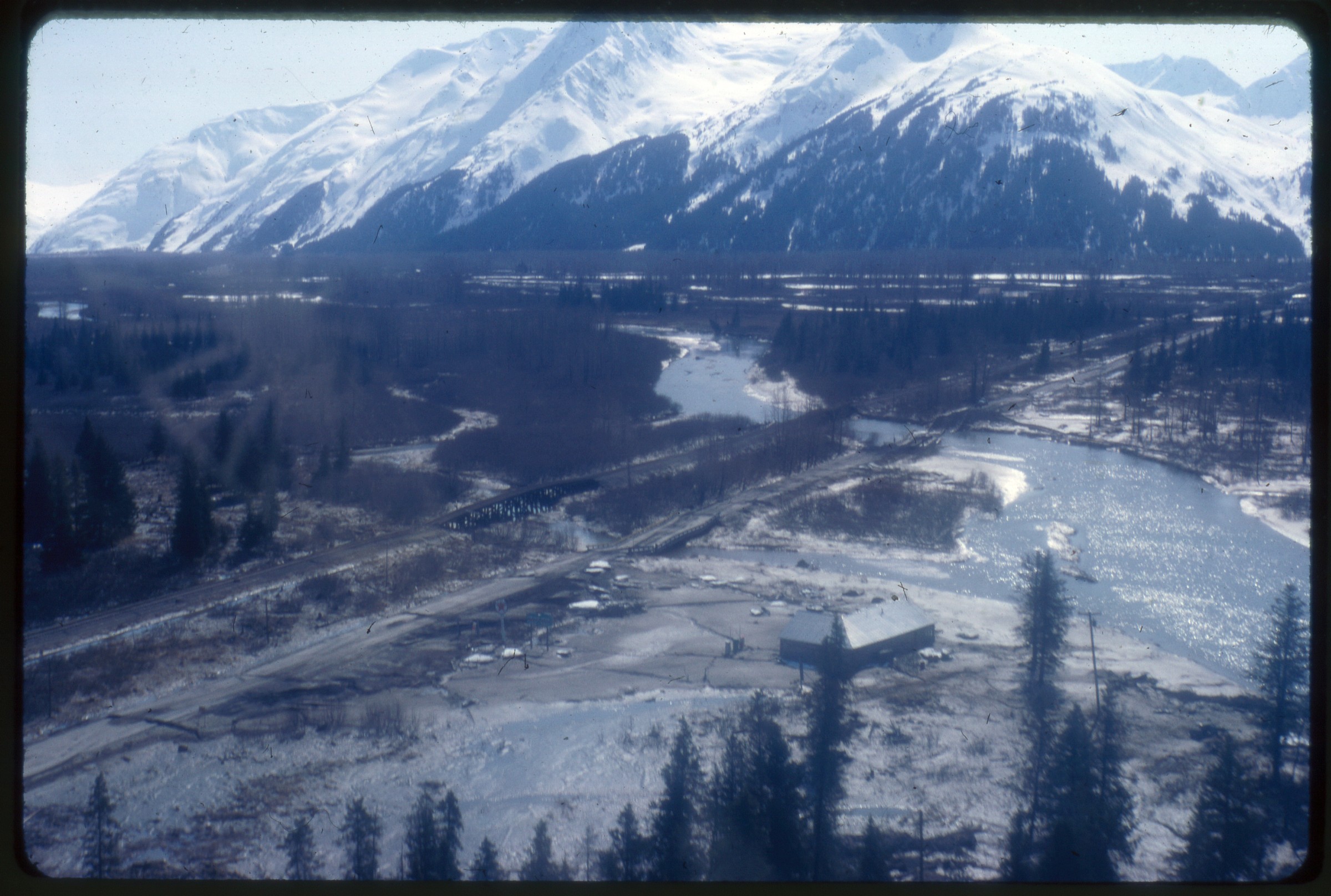
| | 186 — | Tunnel Door #2
|
| | 187 — | Tunnel Door #3 |
| | 188 — | Tunnel Door #4 |
| | 189 — | [scenic with broad river in foreground, Mt. McKinley in background, Talkeetna?]
|
| | 190 — | First two cars derailed at derailment mile 269.6. July 1978, S. C. Love [Canyon to
Chulitna] |
| | 191 — | Looking south at north end of derailment mile 269.6. July 1978, S. C. Love |
| | 192 — | Paul Watts, Weaver Franklin, Roy Stavenjord, Bob Conway, derailment at mile 269.9.
July 1978, S. C. Love |
| | 193 — | Gordon Phillips & W. C. D. inspecting derailment at mile 269.9. July 1978, S. C. Love |
| | 194 — | Derailment at mile 269.6. July 1978, S. C. Love |
| | 195 — | Tank load of LPG, derailment at mile 269.6. July 1978, S. C. Love |
| | 196 — | South end of derailed cars at mile 269.6. July 1978, S. C. Love |
| | 197 — | LC-55 and LC-106 getting ready to pick up LPG tank car, derailment at mile 269.6. July
1978, S. C. Love |
| | 198 — | Trackmen rebuilding track up to derailed box at mile 269.6, wrecker crane 55, F7 engine
1530. July 1978, S. C. Love |
| | 199 — | Rebuilding track at south end of derailment at mile 269.6. July 1978, S. C. Love |
| | 200 — | Trackmen rebuilding track at north end of derailment at mile 269.6. July 1978, S. C.
Love |
| | 201 — | Rebuilding track at north end of derailment, mile 269.6. July 1978, S. C. Love |
| | 202 — | Paul Watts, Rod Harvey, & Harold Larson supervising rebuilding of track at mile 269.6.
July 1978, S. C. Love |
| | 203 — | Section of track being built up to L.P.G. tank car derailment, mile 269.6, July 1978, S. C.
Love |
| | 204 — | LC-55 & eng. 1530 at derailment, mile 269.6. July 1978, S. C. Love |
| | 205 — | Point of derailment on curve 269B, mile 269.45. July 1978, S. C. Love
|
| | 206 — | [two men in suits and ties standing in front of maps on wall; print date Dec 78] |
| | 207 — | Ice jam, Susitna R. ’97 |
| | 208 — | Steel piling & timber on n/g curve 347.A, mile 347.4. April 1980, S. C. Love [McKinley
Park] |
| | 209 — | Wood piling at MP 357. April 1980, S. C. Love [Moody to Suntrana] |
| | 210 — | Rough track conditions and wood pilings, MP 357-357.1. April 1980, S. C. Love |
| | 211 — | North end (14°-30”) curve 357.C, mile 357.6, piling under gravel on both sides. April
20, 1980, S. C. Love |
| | 212 — | [motorbike parked outside of light green corrugated metal two-story building; print date
Jul 80]
|
| | 213 — | [man wearing mukluks and parka with fur trim standing on track in winter, 1940s?] |
| | 214 — | [different man wearing similar dress and in similar pose as .213] |
| | 215 — | [three men next to small speeder in winter, 1940s?] |
| | 216 — | [two men standing on track in winter, one wearing denim shirt and pants, the other
wearing high rubber boots and jacket, buildings and mountains in distance, Anchorage?
1950s?] |
| | 217 — | [man wearing chamois shirt, slacks, and belt posed outdoors, Anchorage? 1950s?]
|
| | 218 — | [man wearing ball cap, jeans, and heavy jacket, carrying camera, in grassy area with hills
in distance] |
| | 219 — | [bird’s eye view of meandering river valley] |
| | 220 — | Tidal bore in Turnagain Arm just off Cook Inlet, Anchorage, Alaska. The bore is 4’
high. Many good size boats have been sunk by similar tides. |
| | 221 — | Deadman Glacier, trestle & B & B-5 outfit, Loop District MP 48.3 |
| | 222 — | Eielson Br. MP 5 8/21 [trestle bridge next to lake] |
| | 223 — | Eielson Br. MP 1 8/21 [damaged trestle bridge over creek] |
| | 224 — | [two men leaning against sign “Highest Point on Alaska Railroad Elevation 2363 Feet”,
Summit Lake, MP 312.5] |
| | 225 — | [close-up of wood pilings underneath metal bridge over waterway] |
| | 226 — | [view looking down riverbank from bridge showing riprap, 1970s?] |
| | 227 — | [close-up of bank erosion underneath bridge, 1970s?] |
| | 228 — | [sandbags piled up under bridge, 1970s?] |
| | 229 — | [distant view of coal-fired power plant at Healy, 1970s] |
| | 230 — | 5-17-77 [bulldozer in water pushing gravel piles to control river direction or flooding] |
| | 231 — | [view of river from bridge, 1970s?] |
| | 232 — | [distant view of town or complex in broad valley, 1970s?] |
| | 233 — | [similar to .232] |
| | 234 — | Steel piling on west side, south approach to Riley Creek Bridge, Mile 347.8 [print date
Apr 80] |
| | 235 — | Steel piling holding track on curve MP 350 (looking north) [print date Apr 80] |
| | 236 — | Bridge 350.3 [near Nenana River Canyon; print date Apr 80] |
| | 237 — | Bridge 351.4 [Nenana River Canyon to Moody; print date Apr 80] |
| | 238 — | Bridge 351.4 south tower [print date Apr 80] |
| | 239 — | Bridge 351.4 north tower [print date Apr 80] |
| | 240 — | Moody slide area, two rows piling [print date Apr 80]
B2 |
| | 241 — | Moody slide area, two rows piling [print date Apr 80] |
| | 242 — | Moody slide showing drainage flume [print date Apr 80] |
| | 243 — | Steel piling and south approach to Bridge 354 [Moody to Suntrana; print date Apr 80] |
| | 244 — | Wood piling at north end curve 354B, mile 354.5 (looking north) [print date Apr 80] |
| | 245 — | Cribbing of piling that has settled toward the river, mile 354.16 (looking north) [print
date Apr 80] |
| | 246 — | South portal Garner Tunnel and rock face, mile 356.2 [print date Apr 80] |
| | 247 — | North portal Garner Tunnel and rock face, mile 356.2 [print date Apr 80] |
| | 248 — | Garner Tunnel north portal [print date Apr 80] |
| | 249 — | Garner Tunnel north portal [print date Apr 80] |
| | 250 — | North portal Garner Tunnel as seen from mile 356.4 [print date Apr 80] |
| | 251 — | [workman near hi-rail dump truck piling gravel onto track near road crossing, 1970s?] |
| | 252 — | [hi-rail dump truck] |
| | 253 — | [similar to .251] |
| | 254 — | [similar to .251] |
| | 255 — | [similar to .251] |
| | 256 — | [hi-rail dump truck]
|
| | 257a — | [similar to .256]
[Series of 4 7/8” square color prints, labeled as groups with no other identifying information,
images of track, equipment, maintenance, and scenery along the routes; some series missing
numbers] |
| | 257b — | 267 - RR1-1 – RR1-11 |
| | 268 — | 288 - RR2-1 – RR2-24
.287 – [four men inspecting track next to railroad motorcar] |
| | 289 — | 310 - RR3-2 – RR3-24
.294 – [engine 3014]
.295 – [engine 1530] |
| | 297 — | [engine 1530] |
| | 300 — | 306 – [train crossing Hurricane Gulch bridge, engine 3007, caboose 1086] |
| | 307 — | 308 – [views from Hurricane Gulch bridge] |
| | 310 — | [hi-rail car on Hurricane Gulch bridge] |
| | 311 — | 325 – RR4-1 – RR4-24
.311 – [two men inside Jeep Wagoneer hi-rail car]
.321-325 – [maintenance cars, including speeder G1105] |
| | 326 — | 341 – RR5-1 – RR5-24
.326 – [coal veins, probably near Healy]
.328 – [hi-rail car and engine 1803 on tracks]
.329 – [caboose 1077 on passing train]
.330-331 – [men standing on riprap, Nenana River?]
.332-333 – [man and Suburban hi-rail car]
.334 – [Golden Spike sign]
.335 – [Mears Memorial Bridge]
.340 – [man with notepad next to piling] |
| | 342 — | 361 – RR6-3 – RR6-24
.357 – [highway bridge over the Nenana River] |
| | 362 — | 383 – RR7-1 – RR7-25
.365-367 – [Park ranger leading group on path, probably Denali National Park]
.368-369 – [distant view of housing]
.377 – [two men walking on track]
.379 – [distant view of numerous recreational vehicles parked in pullout in river bend]
.382 – [hi-rail car stopped at one end of metal bridge] |
| | 384 — | 404 – RR8-1 – RR8-24
.390 – [sign, Leaving Mount McKinley National Park]
.400 – [hi-rail car exiting tunnel]
.404 – [coal-fired power plant at Healy]
Negatives |
| | 405 — | [earthquake damage, 1964, Portage area? 2 ¼ x 3 ½” neg] |
| | 406 — | 409 – [track work, no date; 120mm negs] |
| | 410 — | 411 – [bridge construction or repair, no date, 120mm negs] |
| | 412 — | 413 – [track work and man in office, 8 35mm negs] |
| | 99 — | 105 – [4 x 5” negs for prints with same image number; see descriptions above]
Slides
B3
[1964 Earthquake] |
| | 415 — | 1st train over Br 147.3 w/broken pier, 4/6/64 |
| | 416 — | Br. 15.6 looking s., 5/17/64 |
| | 417 — | Br. 3.3, 5/8/64 |
| | 418 — | Hurricane Br., pier #3 left, 7/22/64 man inspecting crack] |
| | 419 — | Collapse of highway br. over RR |
| | 420 — | Knik River Br. |
| | 421 — | 20.0 [bowed bridge] |
| | 422 — | Br. 34.7 [view down undulating track] |
| | 423 — | Br. 34.7 [close-up of southeast corner] |
| | 424 — | Br. 348 looking south [bowed bridge] |
| | 425 — | Br. 61.9 [close-up of northeast corner] |
| | 426 — | Br. 62.1 looking e [uplifted bridge] |
| | 427 — | Br. 62.1 |
| | 428 — | Br. 62.1 [man holding surveyor’s tripod standing atop uplifted bridge] |
| | 429 — | Br. 62.3 [view down track, man standing next to bridge at right, surveyor’s tripod on
bridge, mountains in background] |
| | 430 — | Br. 100.13 [view down track to stopped train, Potter section house at right] |
| | 431 — | Br. 100.13 [ice in inlet at left, man crouched next to track, Potter section house at right] |
| | 432 — | Br. 140.8 [close-up with tape measure showing extent of displacement] |
| | 433 — | Br. 140.8 [similar to .432] |
| | 434 — | Br. 148.3 [aerial of cracked ice in Matanuska River on either side of bridge] |
| | 435 — | Br. 148.3 [view across bridge showing warped track, helicopter on ice at right] |
| | 436 — | Br. 148.3 [similar to .435] |
| | 437 — | [view down track with landslide at left; print date May 64] |
| | 438 — | [track being repaired, view showing displaced ties and landslide; print date May 64] |
| | 439 — | [track repaired, slide area backfilled; print date May 64] |
| | 440 — | [sections of track and ties in heaved earth, possibly Portage? print date May 64] |
| | 441 — | [aerial of repaired track and bridge; print date May 64] |
| | 442 — | [aerial of work cars and cranes rebuilding section of track in flat, mountains in distance;
print date May 64] |
| | 443 — | [aerial looking down section of track with warping, siding and mountains in distance;
print date May 64] |
| | 444 — | [aerial of siding shown in .443, with cars and warped track; print date May 64] |
| | 445 — | [aerial of Portage, showing Diamond Jim’s, other buildings, automobiles, and track;
print date May 64] |
| | 446 — | [aerial showing railroad and highway bridges over river, with cracked pavement and
collapsed highway bridge; print date May 64] |
| | 447 — | [closer view of .446] |
| 448 — | [aerial showing railroad and highway bridges over two channels of river, probably
Portage Creek, Texaco station and large building in lower right; print date May 64] |
| | 449 — | [aerial of railroad bridge over river with severely warped track on far side, highway
repairs underway at right; print date May 64]
|
| | 450 — | [aerial of collapsed highway and railroad bridges over river; print date May 64] |
| | 451 — | [aerial of damaged track in wooded area; print date May 64] |
| | 452 — | [aerial of track after heavy snowfall; print date May 64] |
| | 453 — | [aerial of bridge over creek with warped track; print date May 64] |
| | 454 — | [aerial of bridge over river with warped track; print date May 64] |
| | 455 — | [aerial of track in flooded area near Turnagain Arm; print date May 64] |
| | 456 — | [large blocks of ice on top of tracks; print date May 64] |
| | 457 — | [helicopter parked near track; print date May 64] |
| | 458 — | [view down track, mountains in distance, utility poles leaning at right, pilot visible in
helicopter parked at left; print date May 64] |
| | 459 — | [view down warped track, man standing in foreground next to milepost 35, Trail Lakes
to Hunter; print date May 64] |
| | 460 — | [bowed bridge; print date May 64] |
| | 461 — | [close-up of track and ties; print date May 64] |
| | 462 — | [man, same as in .459, walking down track to uplifted bridge; print date May 64] |
| | 463 — | [man walking on uplifted bridge; print date May 64] |
| | 464 — | [close-up of track and ties; print date May 64] |
| | 465 — | [aerial of uplifted bridge in boggy area; print date May 64] |
| | 466 — | [aerial of railroad and highway intersection, debris on track, men near truck on road;
print date May 64] |
| | 467 — | [aerial of track through heavily wooded area with cracks in earth on either side; print
date May 64] |
| | 468 — | [aerial of water front area, small boats on land in foreground, section of track ending at
either side of small bridge, road running at right of track, smoke from brush fires, Seward; print
date May 64] |
| | 469 — | [aerial, closer view of section with missing span shown in .468, buildings of Seward in
distance; print date May 64] |
| | 470 — | [aerial of Seward looking south; print date May 64] |
| | 471 — | [aerial of Seward waterfront looking south; print date May 64] |
| | 472 — | [damage to railroad track and Berth 2 in dock area in Seward; print date Jun 64] |
| | 473 — | [similar to .472; print date Jun 64] |
| | 474 — | [closer in view of .473; print date Jun 64] |
| | 475 — | [detail of track damage in Seward dock area; print date Jun 64] |
| | 476 — | [damaged track in Seward dock area; print date Jun 64] |
| | 477 — | [similar to .475; print date Jun 64] |
| | 478 — | [side view of Berth 2; print date Jun 64] |
| | 479 — | [burned rail cars and barrels along track on Seward waterfront; print date Jun 64] |
| | 480 — | [damaged track and cars, Seward yard? print date Jun 64] |
| | 481 — | [damaged cars, Seward yard? print date Jun 64] |
| | 482 — | [damaged track and cars, Seward yard? print date Jun 64] |
| | 483 — | [damaged track and automobile, Seward yard print date Jun 64] |
| | 484 — | [damaged track and debris, Seward yard? print date Jun 64] |
| | 485 — | [damaged track and oil tanks, Seward yard? print date Jun 64] |
| | 486 — | [similar to .485] |
| | 487 — | [detail of damaged track, Seward? print date Jun 64] |
| | 488 — | [bird’s eye view of Seward dock area; print date Jun 64]
|
| | 489 — | [aerial of Seward looking north; print date Jun 64] |
| | 490 — | [aerial, closer in view of Seward looking northeast; print date Jun 64] |
| | 491 — | [similar to .489; print date Jun 64] |
| | 492 — | [aerial of track between hillside and water, part of track destroyed by landslide; print
date Jun 64] |
| | 493 — | ARR 1 [aerial of Whittier in fresh snow] |
| | 494 — | ARR 5 [aerial of rail and highway bridges over Twentymile River] |
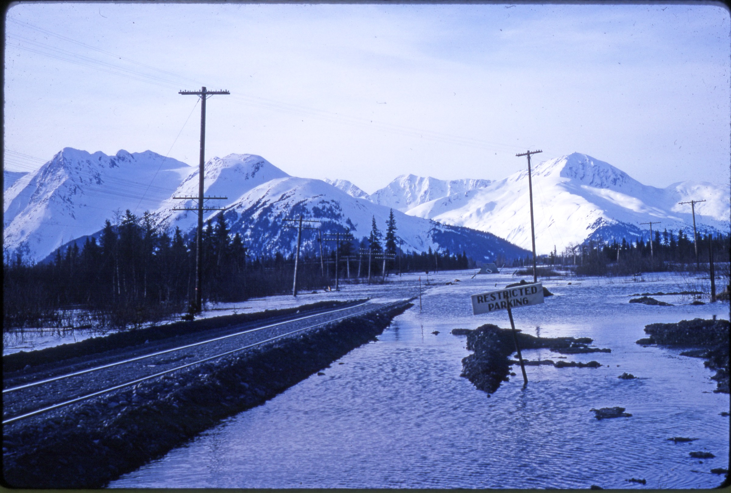
| 495 — | ARR 11 [view down track in heavily flooded area, sign for Restricted Parking, building
in background, Portage; print date May 64. Cf. .509] |
| | 496 — | ARR 12 [view along track with large fissure in earth at left, buildings and utility poles,
Portage?] |
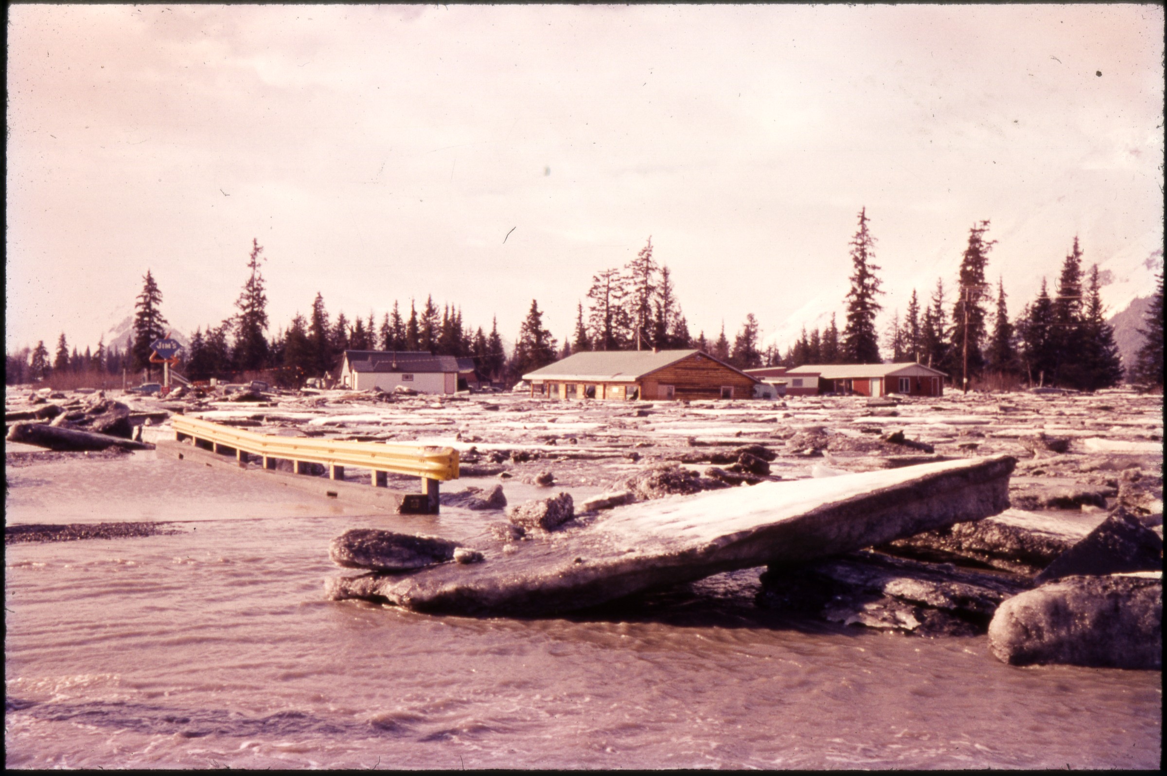
| 497 — | ARR 63. A.J.C. 13 [ice chunks and flooding in Portage, with Diamond Jim’s sign; print
date Apr 64] |
| | 498 — | ARR 14 [aerial of track with fresh snow, warped track] |
| | 499 — | ARR 16 [uplifted bridge; print date Jul 64] |
| | 500 — | ARR 25 [damaged track and debris at yard, Seward?] |
| | 501 — | ARR 33 [damaged track and cars, Whittier yard?] |
| | 502 — | ARR 37 [aerial view of snowy track between mountainside and water, Whittier?] |
| | 503 — | ARR 42 [aerial of burned storage tanks, Whittier?] |
| | 504 — | ARR 46 [view down warped track, wooden bridge in foreground, helicopter on tracks in
middle distance, mountains in background] |
| | 505 — | ARR 53. Whittier [damaged cars in yard; print date Jun 64] |
| 506 — | ARR 55. PH [aerial of track in landslide area, Potter Hill] |
| 507 — | ARR 59. PH [aerial of track in landslide area, Potter Hill] |
| | 508 — | ARR 62. S [damaged cars and track, Seward?] |
| | 509 — | ARR 69. Portage [man with surveyor’s tripod standing on track in heavily flooded area,
same location as in .495] |
| | 510 — | ARR 71. S [burned storage tanks, Seward?] |
| | 511 — | ARR 78. S [automobile, cars, track and debris in yard, Seward?] |
| | 512 — | S [man standing next to engine 1828, Seward] |
| | 513 — | [boats and debris on shore, Seward?] |
| | 514 — | [aerial of railroad track and Seward Highway along Turnagain Arm] |
| | 515 — | [engine 1506]
Guide written: April 18, 2014 |