| | 1 — | 18 – Palmer, Wasilla Area, Werner Home, Snyder’s Fur Farm, Gold Mint Mine. Routes 35D,
E, I, K, L, O
.1 – Rte. 35D, view from mile 4.6 [?] July 20, [1932?] SW Distr. [scenic]
.2 – Rte. 35D, summit, mile 5.2, July 20/32, SW Distr. [two men in snow] |
| | 3 — | Rte. 35D, mile 5.2 at summit, June 8, 1933, SW Distr. [man wearing snowshoes
posed in snow]
|
| | 4 — | Willow Creek, upstream from Alaska R.R. bridge, mi. 169.2, 6/1/31 |
| | 5 — | Rte. 35D [illegible] July 20/32, SW Distr. [men shoveling snow at summit] |
| | 6 — | Rte. 35D, in mile 7, snow removal, July 20, 1932, SW Distr. [two men relaxing next
to snow pile] |
| | 7 — | SW Distr. Rte. 35E, mi. 12.5, looking N, Sept. 3/31 [view between rock
outcroppings] |
| | 8 — | SW Distr. Rte. 35E, mi. 12.5, looking N, Sept. 3, 1931 [view down dirt road] |
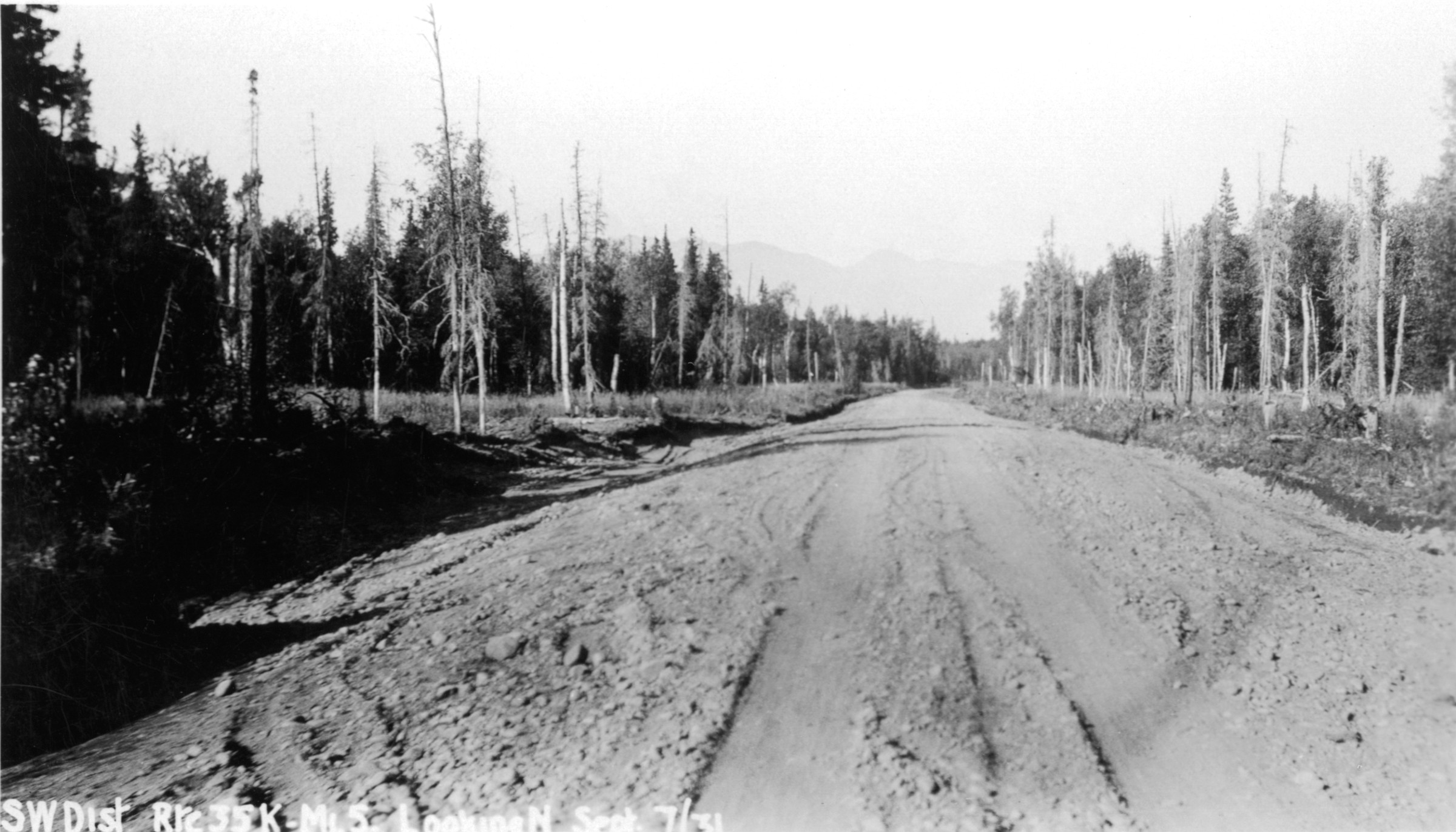
| 9 — | SW Distr. Rte. 35K, mi. 5, looking N, Sept. 7/31 [view down dirt road] |
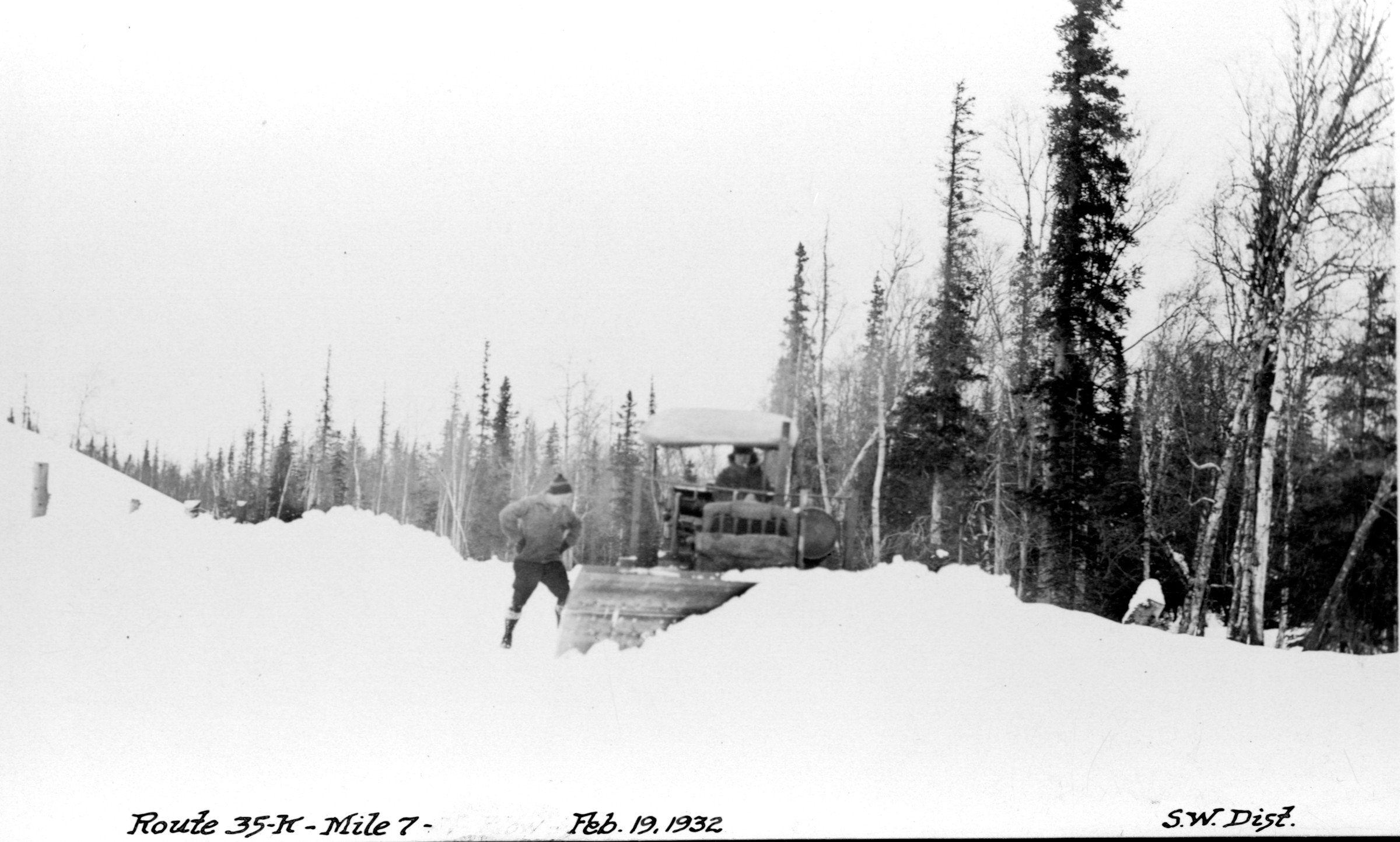
| | 10 — | Route 35K, mile 7, Feb. 19, 1932, SW Distr. [man standing next to snowplow] |
| 11 — | Route 35K, mile 7, Feb. 19, 1932, SW Distr. [man standing next to snowplow] |
| | 12 — | SW Distr. Rte. 35O, mi. 4.25, Gold Mint Mill, Sept. 5/31 [mining complex in Willow
Creek district] |
| | 13 — | Adam & Fanny Werner home, Palmer, Alaska, c[irca] 1932 [log house] |
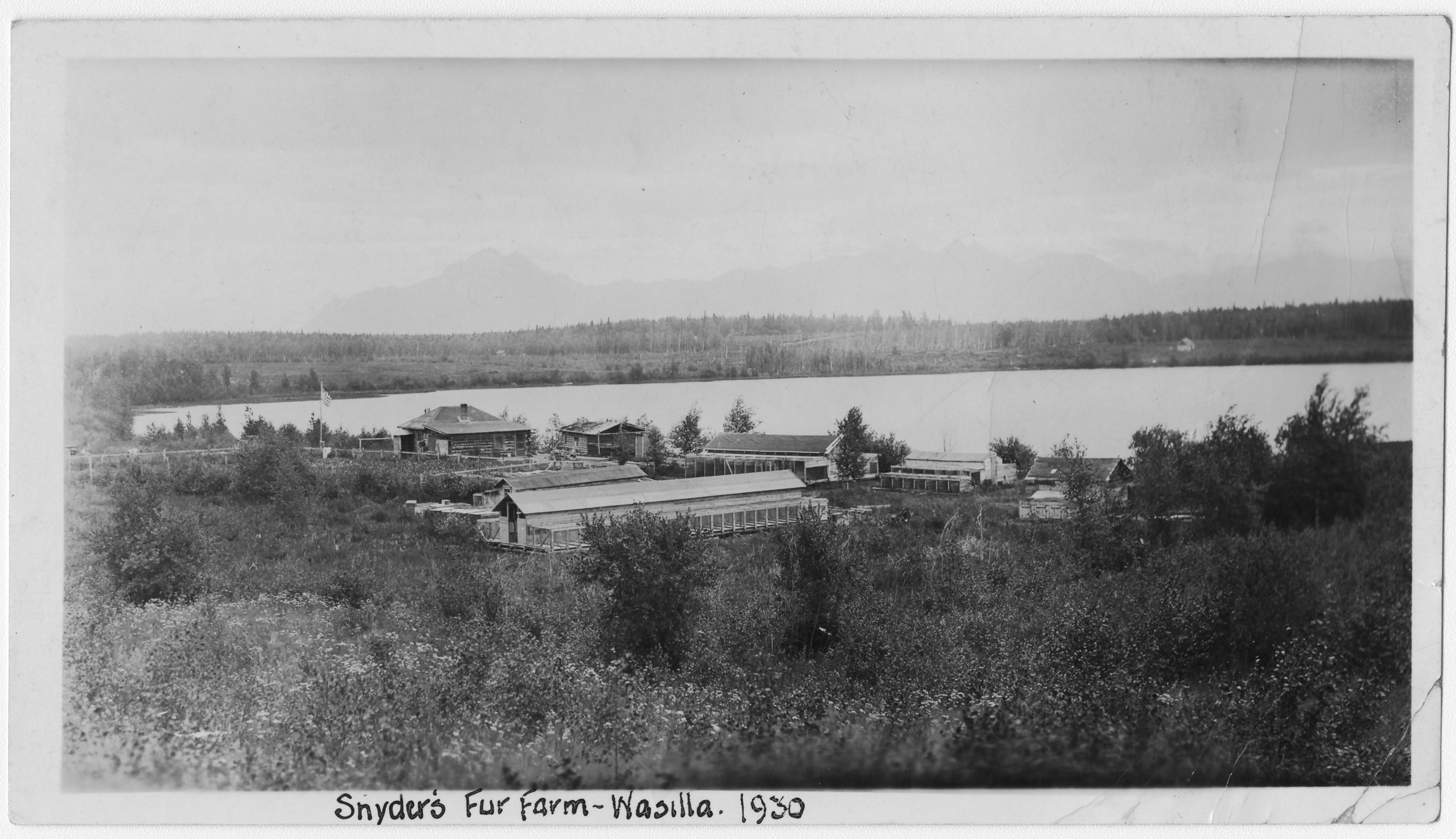
| 14 — | Snyder’s fur farm, Wasilla, 1930 [bird’s eye view of Heinie Snider’s mink farm on
Lake Lucille] |
| | 15 — | Werner connection looking west, R 35T, 1-10-31, SW Distr. [man walking on road
in winter] |
| | 16 — | Palmer-Matanuska, mile 5.5, R 35L, 1-10-31, SW Distr. [view down road in winter] |
| | 17 — | Palmer-Matanuska, mile 3.5, R 35L, 1-10-31, SW Distr. [view down road in winter] |
| | 18 — | Moose, Palmer Road, Werner farm, R 35I, 1-10-31, SW Distr. [view down road in
winter, homestead in far distance] |
| | 19 — | 54 – Willow Creek/Hatcher Pass Area, Lucky Shot Mine, Willow Creek Mine, Talkeetna
Mountains, Middle Camp. Route 35DB, miles 1-19 |
| | 19 — | Rte. 35DB, Willow Cr. mines, Mar. 1933, in mile 1, SW Distr. [man standing next
to Curtiss-Wright 16E biplane tail number NC456W with Independence Mine in
background] |
| | 20 — | SW Distr. Rte. 35DB, mi. 1, head of Willow Creek in Talkeetna Mtns., June 21/31
[scenic] |
| | 21 — | SW Distr. Rte. 35DB, mi. 1, Gold Bullion Peak from Craigie Hill, June 21/31 [scenic] |
| | 22 — | Rte. 35DB, mile 2.5, June 17, 1936, SW Distr. [automobile stopped on gravel road,
with grouse in road] |
| | 23 — | Rte. 35DB, aviation field, mile 4, June 8, 1933, SW Distr. [hangar and airstrip,
Willow Creek airport?] |
| | 24 — | Mile 78, Route 35DB, looking west, 4-12-32, SW Distr. [winter scenic with creek,
snowshoes propped in snow in foreground] |
| | 25 — | SW Distr. Rte. 35DB, mile 9 looking N, Sept. 6, ’31 [clear-cut area in forest] |
| | 26 — | Mile 9, Route 35DB, looking west, 4-12-32, SW Distr. [winter scenic] |
| | 27 — | Rte. 35DB, Willow Cr. bridge, mile 10, June 17, 1936, SW Distr. [truss bridge] |
| | 28 — | Willow Creek, downstream from crossing at mi. 10, Willow-L[uc]ky Shot Mine
Road, 5/25/31 [scenic of creek] |
| | 29 — | Willow Creek downstream from crossing mi. 10, Willow-L[uc]ky Shot Mine Road,
5/25/31 [scenic of creek] |
| | 30 — | SW Distr. Rte. 35DB, mi. 10, Willow Creek, Sept. 3/31 [log bridge] |
| | 31 — | SW Distr. Rte. 35DB, mi. 10, Willow Creek, Sept. 3, 1931 [log bridge]
|
| | 32 — | Willow Creek, upstream from crossing at mi. 10, Willow-L[uc]ky Shot Mine Road,
5/24/31 [scenic of creek] |
| | 33 — | Willow Crk. xing, mile 10, Route 35DB, looking downstream, 4-12-32, SW Distr.
[log bridge in winter] |
| | 34 — | Willow Cr. crossing, mi. 10, Lucky Shot Mine-Willow Trail, 5/24/31 [man standing
on log laid across creek] |
| | 35 — | SW Distr. Rte. 35DB, mi. 11, Willow Creek above canyon, June 18/1931 [scenic] |
| | 36 — | SW Distr. Rte. 35DB, mi. 12, glacial lake, Willow Cr.-Lucky Shot Rd., June 20/31
[scenic] |
| | 37 — | Mile 12.5 looking east, Route 35DB, 4-12-32, SW Distr. [view down right-of-way in
winter] |
| | 38 — | Rte. 35DB, mile 14, middle camp, June 20/1932, SW Distr. [log buildings in
cleared area, wagon in foreground] |
| | 39 — | SW Distr. Rte. 35DB, mi. 15, July 1931, men going to work [crew riding flatbed
trailer being pulled by bulldozer through wooded area] |
| | 40 — | SW Distr. Rte. 35DB, mi. 15 looking N, Jul 15, ’31 [view down rutted dirt road] |
| | 41 — | SW Distr. Rte. 35DB, mi. 16 looking N, Aug. 10/31 [view down muddy road] |
| | 42 — | SW Distr. Rte. 35DB, mi. 18, clearing, July 12, 1931 [man cutting brush] |
| | 43 — | Rte. 35DB, in mile 17, July 16, ’32, grading with rotary, SW Distr. [man standing
next to machinery on muddy road] |
| | 44 — | SW Distr. Rte. 35DB, mi. 18, canyon of Willow Creek from pack trail, June 23/31
[scenic] |
| | 45 — | SW Distr. Rte. 35DB, mile 18, 1931 [view down dirt road through forest] |
| | 46 — | SW Distr. Rte. 35DB, mi. 19, July 1931 [view down dirt road through forest] |
| | 47 — | SW Distr. Rte. 35DB, mi. 19, canyon of Willow Creek from pack trail, June 25/31
[scenic] |
| | 48 — | SW Distr. Rte. 35DB, pack train Willow Cr. survey, June 25/31 [horses loaded with
supplies grazing in clearing] |
| | 49 — | Rte. 35DB, middle camp garage, June20, 1932, SW Distr. [three men standing
next to log building housing bulldozer] |
| | 50 — | Middle camp, Route 35DB, 4-12-32, SW Distr. [log buildings in cleared area in
winter, sled loaded with lumber in foreground] |
| | 51 — | SW Distr. Rte. 35DB, clearing with tractor [wooded area, equipment at far left] |
| | 52 — | [on verso:] Willow Creek, hauling timbers, looking south [workmen with
equipment placing logs along right-of-way in wooded area in winter] |
| | 53 — | [on verso:] Dec. 7
th
, right channel, looking south, upstream [workmen
constructing log bridge, tractor in background, Willow Creek] |
| | 54 — | [on verso:] Right channel, Willow [Creek], Dec. 5
th
, 1931, looking east (upstream)
[log bridge under construction, truss bridge in background right] |
| | 55 — | 83 – Deception Creek Area, Deception Creek, Road building. Route 35DB, miles 20-26 |
| | 55 — | Rte. 35DB, in mile 20, July 17, 1932, SW Distr. [tractor on road being cleared
through forest] |
| | 56 — | Rte. 35DB, grading mile 20, June 22, 1933, SW Distr. [man standing on equipment
being pulled by tractor along right-of-way]
|
| | 57 — | SW Distr. Rte. 35DB, mi. 21, looking N, July 15/31 [faint wagon wheel tracks in
low brush] |
| | 58 — | SW Distr. Rte. 35DB, mi. 21, survey camp, Willow Creek, June 6/31 [men seated
inside tent] |
| | 59 — | SW Distr. Rte. 35DB, mi. 22, looking E, July 15/31 [view down right-of-way] |
| | 60 — | SW Distr. Rte. 35DB, mi. 23, July 12, ’31 [wagon wheel tracks in wooded area] |
| | 61 — | Rte. 35DB, mile 24, showing corduroy, Sept. 26/32, SW Distr. [view down log
road] |
| | 62 — | Rte. 35DB, in mile 24, June 22, 1933, SW Distr. [view down dirt road] |
| | 63 — | Rte. 35DB, Deception Creek, mile 25, June 15, 1932, SW Distr. [log bridge] |
| | 64 — | Rte. 35DB, mile 25, Deception Creek, Sept. 26, 1932, SW Distr. [view down creek,
log bridge supports on both banks] |
| | 65 — | Rte. 35DB, mile 25, Deception Creek, Sept. 26, 1932, SW Distr. [view down creek,
log bridge supports on both banks] |
| | 66 — | Rte. 35 DB, Deception Cr. bridge, mile 25, June 22, 1933, SW Distr. [wooden truss
bridge] |
| | 67 — | Rte. 35DB, Deception Cr., mile 25, Oct. 1932, SW Distr. [bridge under
construction, men standing on bank at right] |
| | 68 — | Rte. 35DB, mile 28, June 20/1932, SW Distr. [automobile stopped in low brush] |
| | 69 — | Rte. 35DB, June 20, 1932, Mile 26, erecting camp, SW Distr. [men pitching tents in
clearing] |
| | 70 — | Rte. 35DB, mile 26, June 22, 1933, SW Distr. [view down dirt road] |
| | 71 — | Rte. 35DB, mile 26, June 22, 1933, looking W, SW Distr. [view down dirt road] |
| | 72 — | Deception Creek bridge, looking north, Rte. 35DB, Nov. 25, 1932, SW Distr.
[wooden truss bridge, man standing at right] |
| | 73 — | Deception Creek bridge, looking west, Rte. 35DB, Nov. [18?], 1932, SW Distr.
[men constructing log bridge] |
| | 74 — | Deception Creek bridge, looking east, Rte. 35DB, Nov. 18, 1932, SW Distr. [log
bridge under construction] |
| | 75 — | Deception Creek bridge, looking north, Rte. 35DB, Nov. 25, 1932, SW Distr. [men
on wooden truss bridge in winter] |
| | 76 — | [on verso:] One of our winter scenes. Dec[eption] Crk. looking east, Dec. 8
th
[man
standing next to tractor mired in overflow in winter] |
| | 77 — | [on verso:] Look west from Dec[eption] Crk. bridge, Dec. 8
th
[wagon mired in
overflow, tractor on road] |
| | 78 — | [on verso:] Deception Creek, 35DB, Dec. 5, looking northwest [scenic] |
| | 79 — | [on verso:] Left channel looking upstream (east), Dec. 5
th
[logs laid across creek] |
| | 80 — | [on verso:] Deception Creek, looking east, Dec. 8
th
[tractor mired in overflow at
right, man standing next to supply sled at left] |
| | 81 — | [on verso:] Left channel, Dec. 5
th
, looking south [logs across creek in foreground,
tent in trees in background] |
| | 82 — | [on verso:] Looking east from right bank Deception showing overflow [scenic] |
| | 83 — | [on verso:] Looking east from right bank Deception [overflow]
|
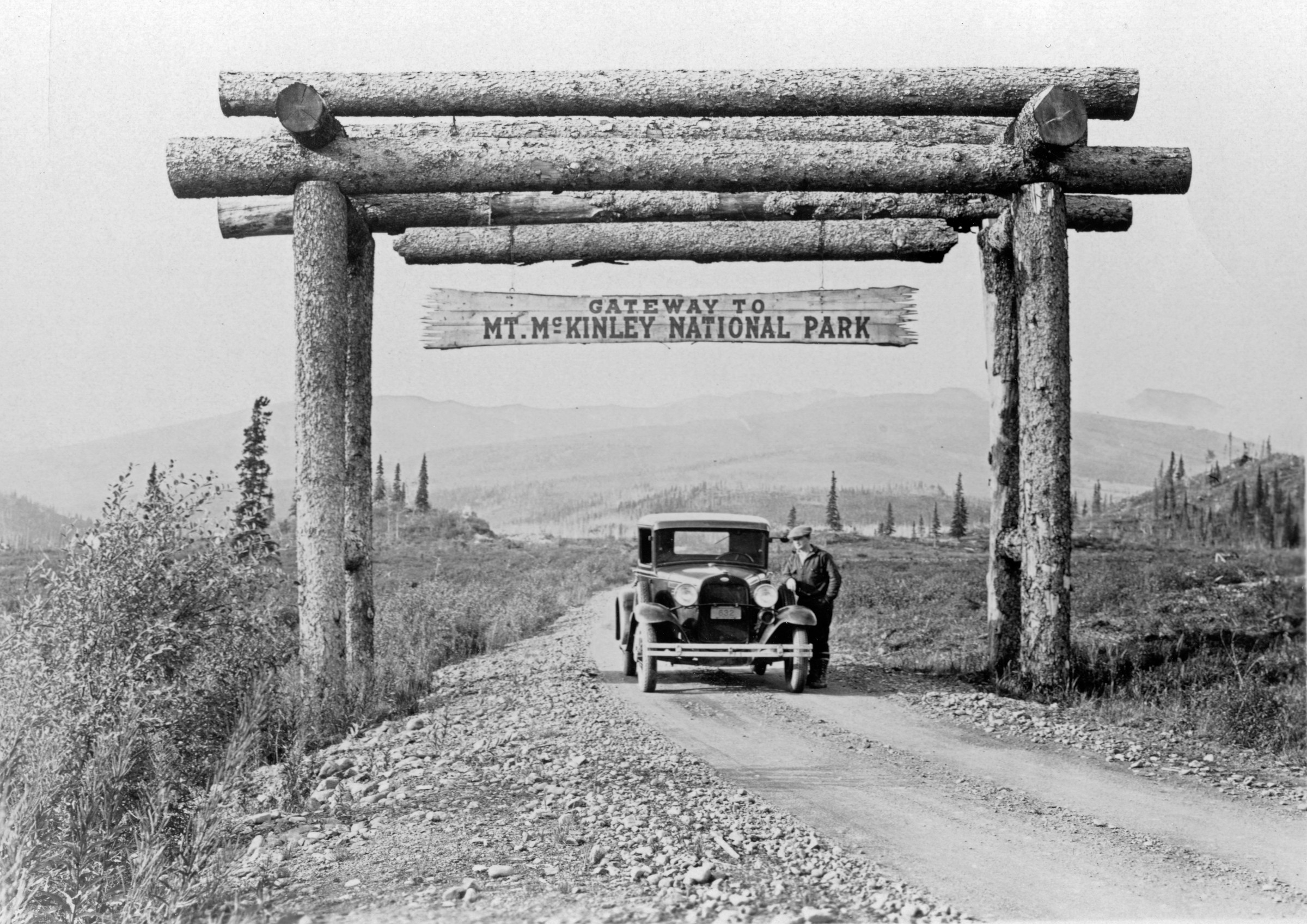
| 84 — | 98 – Mt. McKinley Park Road, Park Gate, Scenery, Inspiration Point, Sanctuary River,
Animals - Caribou, Ptarmigan. Route 46D, miles 0-22 |
| 84 — | [on verso:] Harry Hoyt [man standing next to automobile underneath log arch
with sign, “Gateway to Mt. McKinley National Park”] |
| | 85 — | McKinley Park, view north from mile 3.6, July 5/32 [scenic of creek] |
| | 86 — | McKinley Park Road, Route 46D, mile 6, 7-26-31, SW Distr. [wooden bridge over
small creek] |
| | 87 — | Rte. 46D, mile 8, stream control, June 12, 1932, SW Distr. [two automobiles on
dirt road near wooden bridge] |
| | 88 — | Rte. 46D, mile 8, June 14/32, stream control, SW Distr. [automobile parked on
wooden bridge at left, boulders piled for riprap along creek at right] |
| | 89 — | Rte. 46D, mile 8, stream control, SW Distr., June 12, 1932 [men wrapping
boulders in netting to create riprap along bank] |
| | 90 — | Rte. 46D, mile 8, June 12, 1932, stream control, SW Distr. [view underneath
wooden bridge, showing riprap placed next to bridge support] |
| | 91 — | McKinley Park, mile 9, caribou, June 12, 1932 [two caribou on tundra] |
| | 92 — | Rte. 46D, mile 10, June 14, 1932, ptarmigan near mile 10, SW Distr. [bird on
rocks] |
| | 93 — | SW Distr. Rte. 46D, mi. 10.5, glacial stream, Sept. 5/31 [men constructing wooden
structure in streambed, wagon in foreground, tractor at left] |
| | 94 — | Rte. 46D, mile 16.5, “Inspiration Point,” Sept. 6
th
, 1932, SW Distr. [marker on
tundra] |
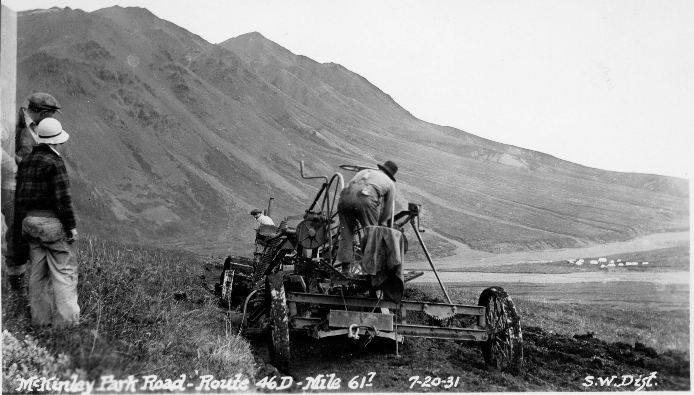
| | 95 — | SW Distr., Rte. 46D, mi. 18.7, fall freighting, Nov. 1930 [several trucks stopped on
winter road, man in foreground shoveling snow] |
| | 96 — | Rte. 46D, mile 22, Sanctuary River cribbing, July 4, 1932, SW Distr. [logs placed
along shoreline for erosion control] |
| | 97 — | Sanctuary River, McKinley Park, July 6, 1932 [view downriver to bridge in
distance] |
| | 98 — | Rte. 46D, Sanctuary River, mile 22, July 6, 1932, SW Distr. [view downriver to
bridge in distance] |
| | 99 — | 113 – Mt. McKinley Park Road, Teklanika River, Moose, Equipment. Route 46D, miles 30.5-
37
.99 – Rte. 46D, mile 30.5, Aug. 1932, SW Distr. [grader on dirt road] |
| | 100 — | Rte. 46D, mile 31, bank protection, Teklinika River, Aug. 1932, SW Distr. [log
cribbing along bank near wooden bridge, Teklanika River] |
| | 101 — | Rte. 46D, mile 31, bank protection, Teklinika River, Aug. 1932, SW Distr. [log
cribbing along bank near wooden bridge, Teklanika River] |
| | 102 — | McKinley Park, R. 46D, west end Teklanika Bridge, mile 31, 9/15/30, SW Distr.
[wooden bridge] |
| | 103 — | McKinley Park, mile 32, moose, June 12, 1932 [distant view of moose crossing
dirt road. Cf. .1039] |
| | 104 — | McKinley Park, mile 32, moose, June 12, 1932 [distant view of moose on tundra] |
| | 105 — | McKinley Park, mile 32, moose, June 12, 1932 [distant view of moose on tundra] |
| | 106 — | McKinley Park, mile 32, moose, June 12, 1932 [distant view of moose on tundra]
|
| 107 — | Rte. 46D, washout, mile 37, June 18, 1933, SW Distr. [flooding in small valley] |
| | 108 — | SW Distr. Rte. 46D, dyke for stream diversion, Igloo Creek, mile 37, July 20/31
[wooden bridge over creek] |
| | 109 — | SW Distr. Rte. 46D, dyke for stream diversion, Igloo Creek, mi. 37, July 20/31
[view along earthen dike] |
| | 110 — | Rte. 46D, mile 37.3, June 10, 1932, grading, SW Distr. [man standing on grader] |
| | 111 — | Rte. 46D, mile 37.3, blasting, July 9, 1932, SW Distr. [view down dirt road to
explosion] |
| | 112 — | Rte. 46D, mile 37.7, June 13, 1932, power grader, SW Distr. [man standing on
modern grader] |
| | 113 — | Rte. 46D, mile 37.7, June 13/1932, power grader, SW Distr. [man standing on
modern grader] |
| | 114 — | 133 – Mt. McKinley Park Road, Equipment, Scenery, Animals - Bear, Marmot, Crew,
Bridge. Route 46D, miles 40.4-47 |
| | 114 — | SW Distr., mile 40.4, June 13, 1932, thawing culverts, Rte. 46D [three men with
steam heater, man at right holding axe, truck parked at right] |
| | 115 — | McKinley Park, looking S from mi. [45.1?], June 2/31, SW Distr. [bird’s eye view
of river valley] |
| | 116 — | Rte. 46D, mile 43, June 14, 1932, showing bear, SW Distr. [bear on tundra] |
| | 117 — | McKinley Park, R. 46D, moving camp across East Fork, mile 43, 9/16/30, SW
Distr. [tractor pulling wagons loaded with supplies across river] |
| | 118 — | Rte. 46D, mile 44, June 7, 1932, SW Distr. [automobile parked between piles of
snow] |
| | 119 — | Rte. 46D, mile 45, June 8, 1932, SW Distr. [man operating excavator for snow
removal, truck parked in background] |
| | 120 — | Rte. 46D, mile 45, June 8, 1932, SW Distr. [man operating excavator for snow
removal, truck parked in background] |
| | 121 — | Rte. 46D, mile 45, June 8, 1932, SW Distr. [distant view of excavator at work] |
| | 122 — | SW Distr. Rte. 46D, mi. 45, rock crew, Aug. 1930 [three men standing in
riverbed. Same as .831] |
| | 123 — | McK. Park, mi. 45 [bird’s eye view of river valley] |
| | 124 — | McKinley Park Road, Route 46D, mile 45.4, lunch counter, 7-14-31, SW Distr.
[man preparing food on wooden board laid across two metal barrels, boxes from
explosives and catsup under table, rubber tire at right] |
| | 125 — | McKinley Park, R. 46D, mile 45.4, 9/15/30, SW Distr. [supplies and metal barrels
on scree along rock wall] |
| | 126 — | SW Distr. Rte. 46D, mi. 45.5, Aug. 30/31 [excavator at base of rock wall] |
| | 127 — | SW Distr. Rte. 46D, mi. 46, looking N, June 1930 [scenic] |
| | 128 — | McKinley Park, marmot near mile 46, June 10, 1932 |
| | 129 — | McKinley Park, mi. 46.5, looking E, June 10/31, SW Distr. [scree slope. Same as
.803] |
| | 130 — | McKinley Park, mi. 46.5, looking E, June 2, 1931, SW Distr. [view of road along
mountainside]
|
| | 131 — | SW Dist. Rte. 46D, mi. 47, looking E, Aug. 15/31 [man operating excavator on
scree slope]
.131.2 – Rte. 46D, highline of mile 47, Aug. 1936, SW Distr. [distant view of automobile
on road above river valley] |
| | 132 — | McKinley Park Road, Route 46D, mile 47, 7-13-31, SW Distr. [man operating
excavator on road] |
| | 133 — | McKinley Park Road, Route 46D, mile 47.3, 7-3-31, SW Distr. [small wooden
bridge] |
| | 134 — | 164 – Mt. McKinley Park Road, Igloo Creek, Toklat Bridge construction. Route 46D, miles
51-59.5 |
| | 134 — | McKinley Park, Alaska, Igloo Creek, July 4, 1932 [man and young boy riding in
horse-drawn wagon on muddy road] |
| | 135 — | SW Dist. Rte. 46D, mi. 51, looking E, Oct. 1, 1931 [two Dall sheep next to road in
winter] |
| | 136 — | Rte. 46D, mi. 52.8, looking W, Sept. 28, ’31 [wheel tracks in snow,
photographer’s shadow in foreground] |
| | 137 — | Rte. 46D, mi. 53, E approach Toklat Bridge, Sept. 28/31 [view down river in
winter, bridge in left background] |
| | 138 — | Rte. 46D, mi. 53, E approach Toklat Bridge, Sept. 28, ’31 [view across snow to
rock wall, truck parked at right] |
| | 139 — | SW Dist. Rte. 46D, mi. 53, east abutment Toklat Bridge, 1931 [rockfall, two men
standing next to equipment at left] |
| | 140 — | SW Dist. Rte. 46D, mi. 53, E approach Toklat Bridge, Sept. 28/31 [rock wall] |
| | 141 — | SW Dist. Rte. 46D, mi. 53, road camp, Aug. 1931 [distant view of tents and
equipment] |
| | 142 — | Rte. 46D, mi. 53.2, looking W, Sept. 28/31 [men operating excavator next to
rock wall] |
| | 143 — | SW Dist., mi. 53.2, Rte. 46D, showing rock-work, Sept. 28/31 [men operating
excavator next to rock wall] |
| | 144 — | SW Dist., Rte. 46D, mi. 53.5, looking N, Sept. 6, 1931 [distant view of equipment
in riverbed, bridge under construction, tent at far left] |
| | 145 — | SW Dist. Rte. 46D, mi. 53.5, Toklat Bridge, Sept. 28, ’31 [tractor and wagon next
to bridge piers, winter bridge construction] |
| | 146 — | Rte. 46D, mile 53.5, E channel Toklat, Sept. 7, 1932, SW Dist. [wooden bridge] |
| | 147 — | SW Dist. Rte. 46D, mi. 53.5, Toklat Bridge, Aug. 30, 1931 [men constructing
bridge] |
| | 148 — | Rte. 46D, mi. 53.5, Toklat Bridge, W channel, looking N, Sept. 28, ’31 [bridge
under construction] |
| | 149 — | SW Dist. Rte. 46D, mi. 53.9, W approach Toklat Br., Oct. 20, 1931 [two men with
truck on wooden bridge] |
| | 150 — | SW Dist. Rte. 46D, mi. 54, looking E across Toklat R., Aug. 1931 [men with pile
driver and other equipment on riverbank] |
| | 151 — | SW Dist. Rte. 46D, mi. 55, Sept. 29, ’31 [scenic] |
| | 152 — | SW Dist. Rte. 46D, mi. 55, looking N, Oct. 1, 1931 [scenic]
|
| | 153 — | SW Dist. Rte. 46D, Mt. McKinley from mi. 55, looking W [scenic] |
| | 154 — | Rte. 46D, mile 55.3, July 12, 1932, hand grading, SW Distr. [men with shovels
working on dirt road. Cf. .246] |
| | 155 — | Rte. 46D, mile 55.3, hand grading, July 12, 1932, SW Distr. [men with shovels
working on dirt road] |
| | 156 — | Rte. 46D, mile 55.9, looking W, Sept. 7, 1932, SW Dist. [view down dirt road] |
| | 157 — | Rte. 46D, near mile 56, June 15, 1932, SW Dist. [scenic] |
| | 158 — | Rte. 46D, mile 56.85, July 10, 1932, SW Distr. [men constructing bridge] |
| | 159 — | Rte. 46D, in mile 57, July 15, 1932, SW Distr. [wooden bridge] |
| | 160 — | Rte. 46D, snow in mile 57, June 15, 1932, SW Distr. [scenic] |
| | 161 — | SW Dist. Rte. 46D, mi. 55, June 1931 [distant view of large caribou herd, man in
foreground] |
| | 162 — | Rte. 46D, mile 59.5, looking W, Sept. 2, 1932, SW Dist. [view down riverbed to
small wooden bridge, truck parked at left] |
| | 163 — | SW Dist. Rte. 46D, Toklat Bridge embankment, Aug. 1931 [tractor pulling roller
over road, truck parked at left] |
| | 164 — | SW Dist., Rte. 46D, Toklat Bridge embankment between trestles, Aug. 30, ’31
[equipment next to earthen pile. Print torn] |
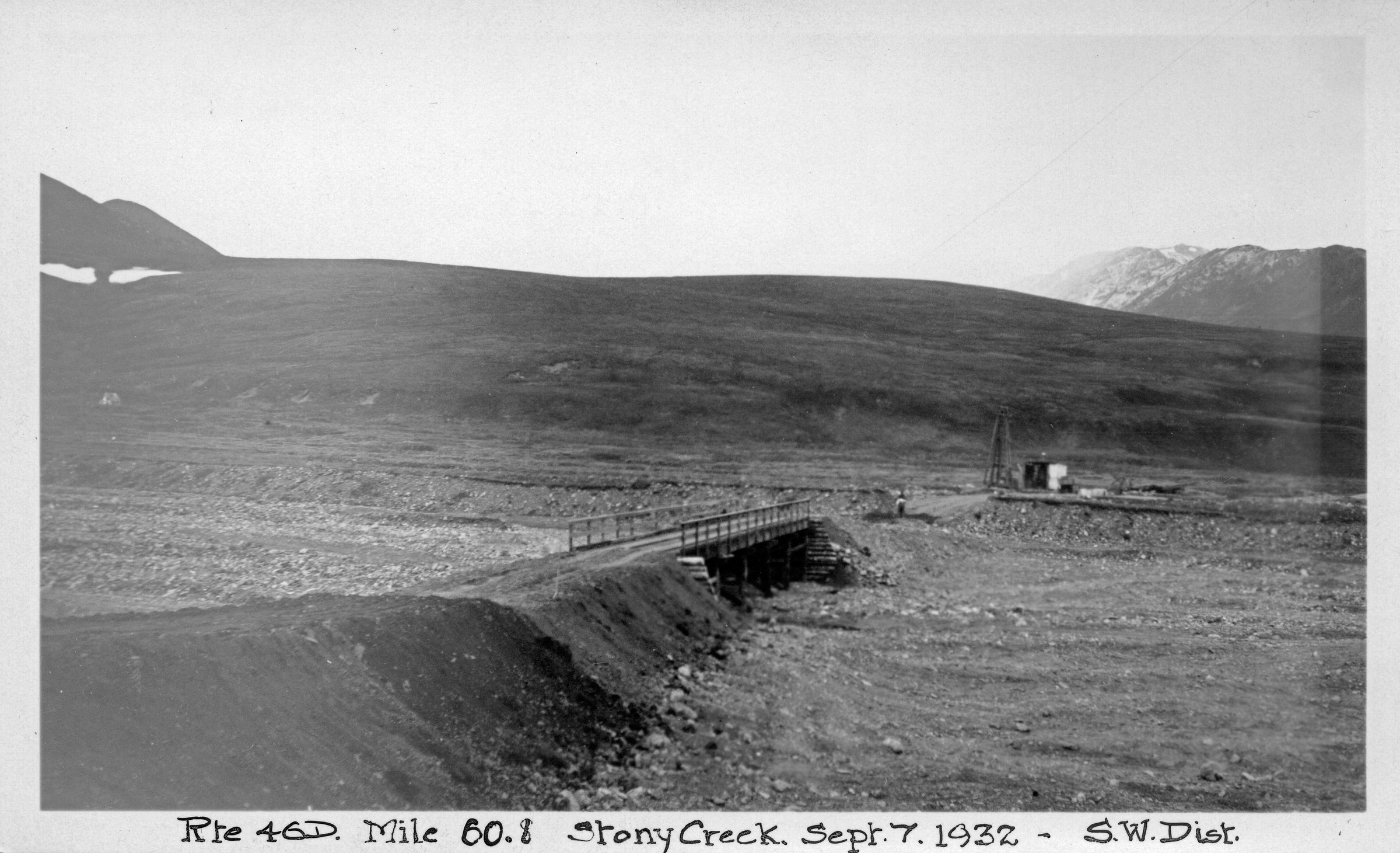
| | 165 — | 181 – Mt. McKinley Park Road, Stoney Creek, Equipment. Route 46D, miles 60-61.7 |
| | 165 — | Rte. 46D, in mile 60, grading with Adams grader, July 2/32, SW Dist. [grader and
tractor on road] |
| | 166 — | SW Dist. Rte. 46D, grading, mile 60, July 28/32 [grader and tractor on road] |
| | 167 — | SW Dist. Rte. 46D, pack trail, Stony Creek, mi. 60.5 [men and horses in tent
camp] |
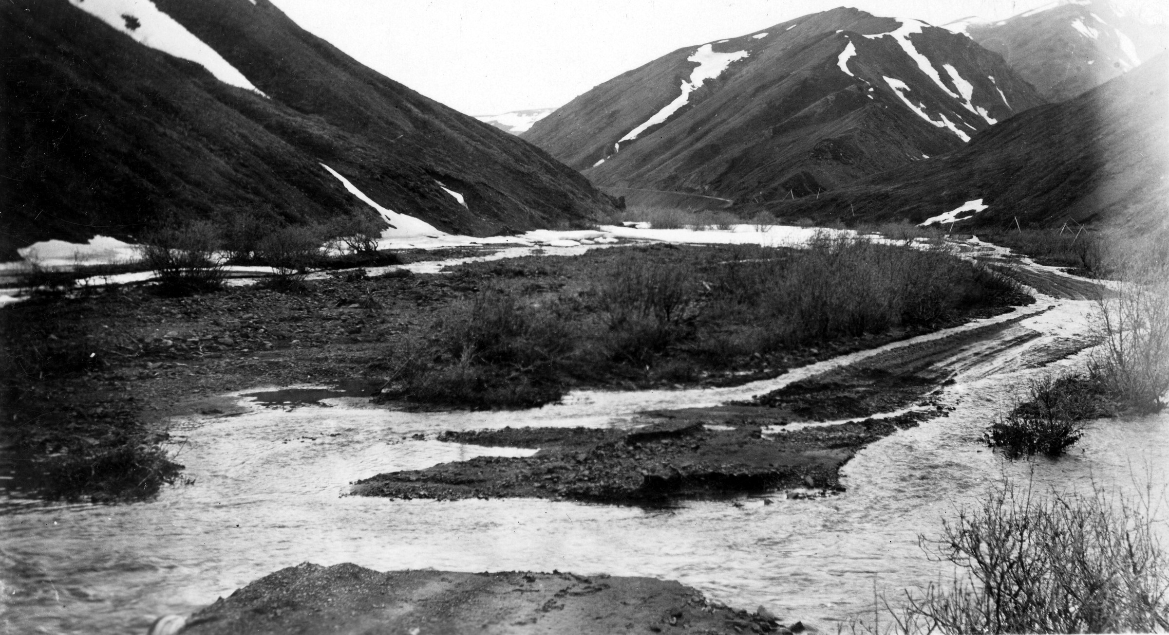
| 168 — | Rte. 46D, mile 60.8, Stony Creek, Sept. 7, 1932, SW Dist. [bird’s eye view of
wooden bridge, equipment beyond] |
| | 169 — | Rte. 46D, mile 60.8, Stony Creek, Sept. 7, 1932, SW Dist. [view down riverbed to
wooden bridge] |
| | 170 — | Rte. 46D, mile 60.8, Stony Creek, lkg. S, Sept. 2, 1932 [view down riverbed to
two men on bridge under construction] |
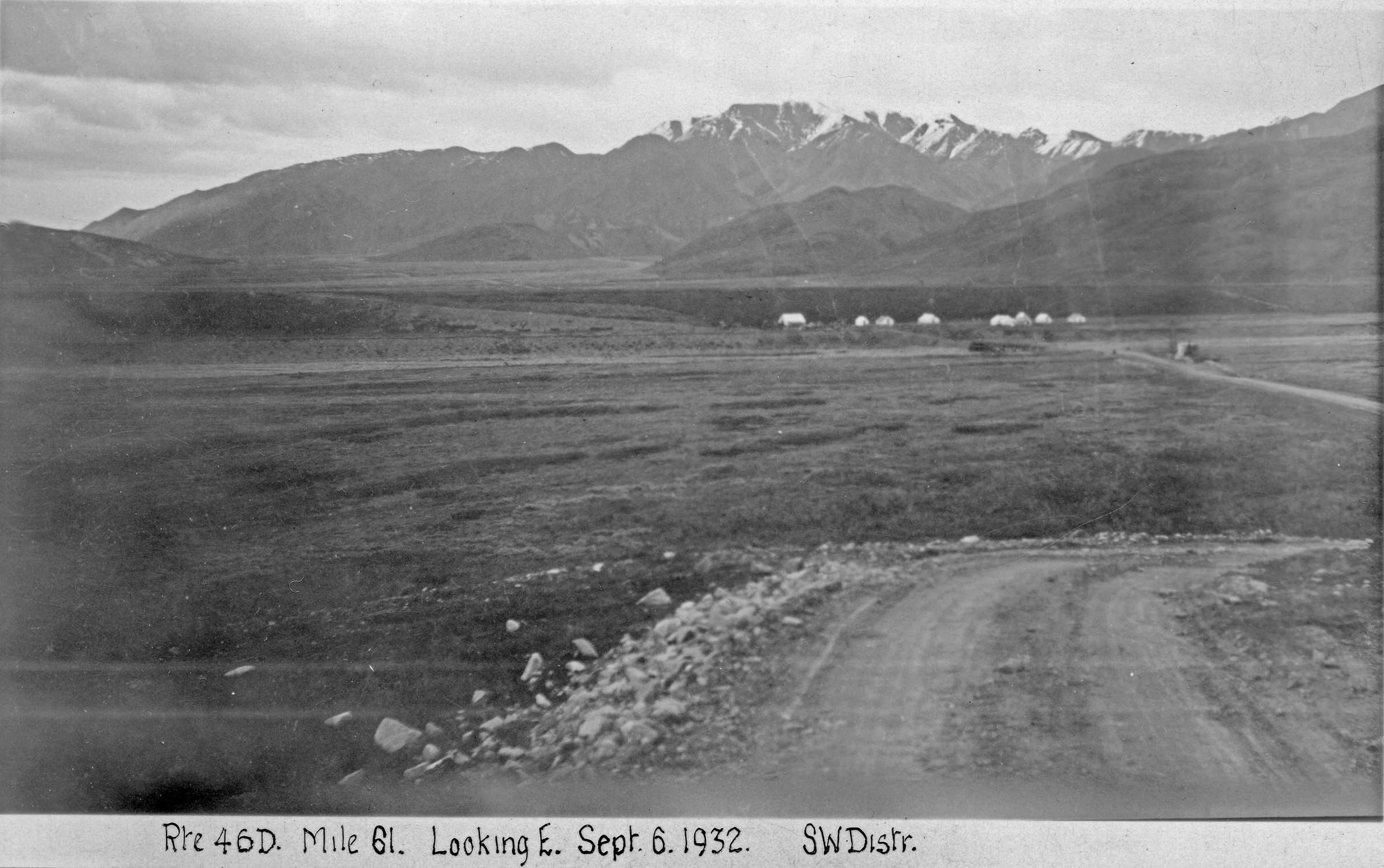
| 171 — | Rte. 46D, mile 61, looking E, Sept. 6, 1932, SW Distr. [distant view of tent camp
on tundra] |
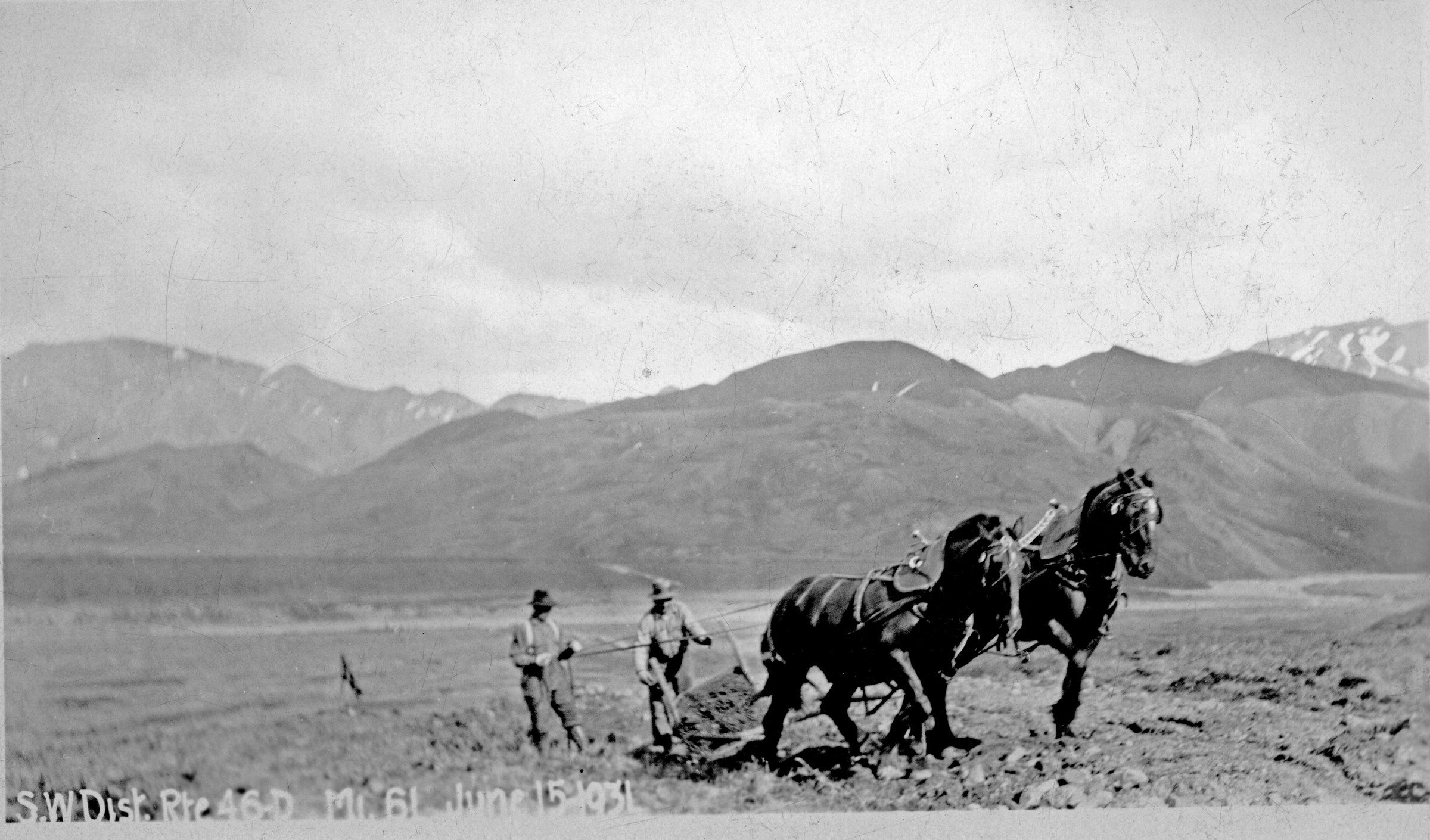
| | 172 — | SW Dist. Rte. 46D, June 1931, mi. 61 [men with tractor] |
| 173 — | SW Dist. Rte. 46D, mi. 61, June 15, 1931 [two men with horse-drawn plow] |
| | 174 — | SW Dist. Rte. 46D, mi. 61, looking E, June 1931 [view down right-of-way on
tundra] |
| | 175 — | SW Dist., Rte. 46D, mi. 61, Stoney Creek, looking W, July 20/31 [view across
riverbed, Stony Creek] |
| | 176 — | McKinley Park Road, Route 46D, mile 61.2, 7-20-31, SW Dist. [view down dirt
road] |
| | 177 — | SW Dist. Rte. 46D, mi. 61.5, June 1931 [two tractors pulling plows on road] |
| | 178 — | SW Dist. Rte. 46D, mi. 61.5, June 1931 [men with tractors] |
| 179 — | McKinley Park Road, Route 46D, mile 61.7, 7-20-31, SW Dist. [men with graders
on road, tent camp in right background]
|
| | 180 — | McKinley Park Road, Route 46D, mile 61.7, 7-13-31, SW Dist. [men with tractor
pulling grader] |
| 181 — | McKinley Park Road, Route 46D, mile 61.7, looking east, 7-25-31, SW Dist.
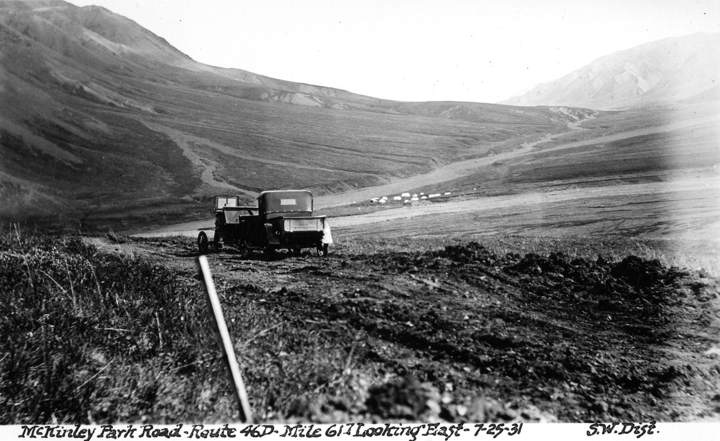
[equipment on road, tent camp in right background] |
| | 182 — | 208 – Mt. McKinley Park Road, Equipment, Hand grading, Survey crew, Mt. McKinley.
Route 46D, miles 62-69 |
| | 182 — | McKinley Park Road, Route 46D, mile 63.2, 7-25-31, SW Dist. [distant view of
tent on tundra, equipment on road in distance] |
| | 183 — | SW Dist. Rte. 46D, mi. 64.5, looking W, July 1931 [men with tractor pulling
grader] |
| | 184 — | SW Dist. Rte. 46D, mi. 65, looking E [men with tractor pulling grader. Same as
.185] |
| | 185 — | SW Dist. Rte. 46D, mi. 65, looking E [same as .184] |
| | 186 — | SW Dist. Rte. 46D, mi. 65, grading, Aug. 15, ’31, lkg. E [men with tractor pulling
grader] |
| | 187 — | SW Dist. Rte. 46D, mi. 65, grading [men with tractor pulling grader. Same as
.188] |
| | 188 — | SW Dist. Rte. 46D, mi. 65, grading [same as .187] |
| | 189 — | Mt. McKinley from mile 65, July 27, 1932 [scenic] |
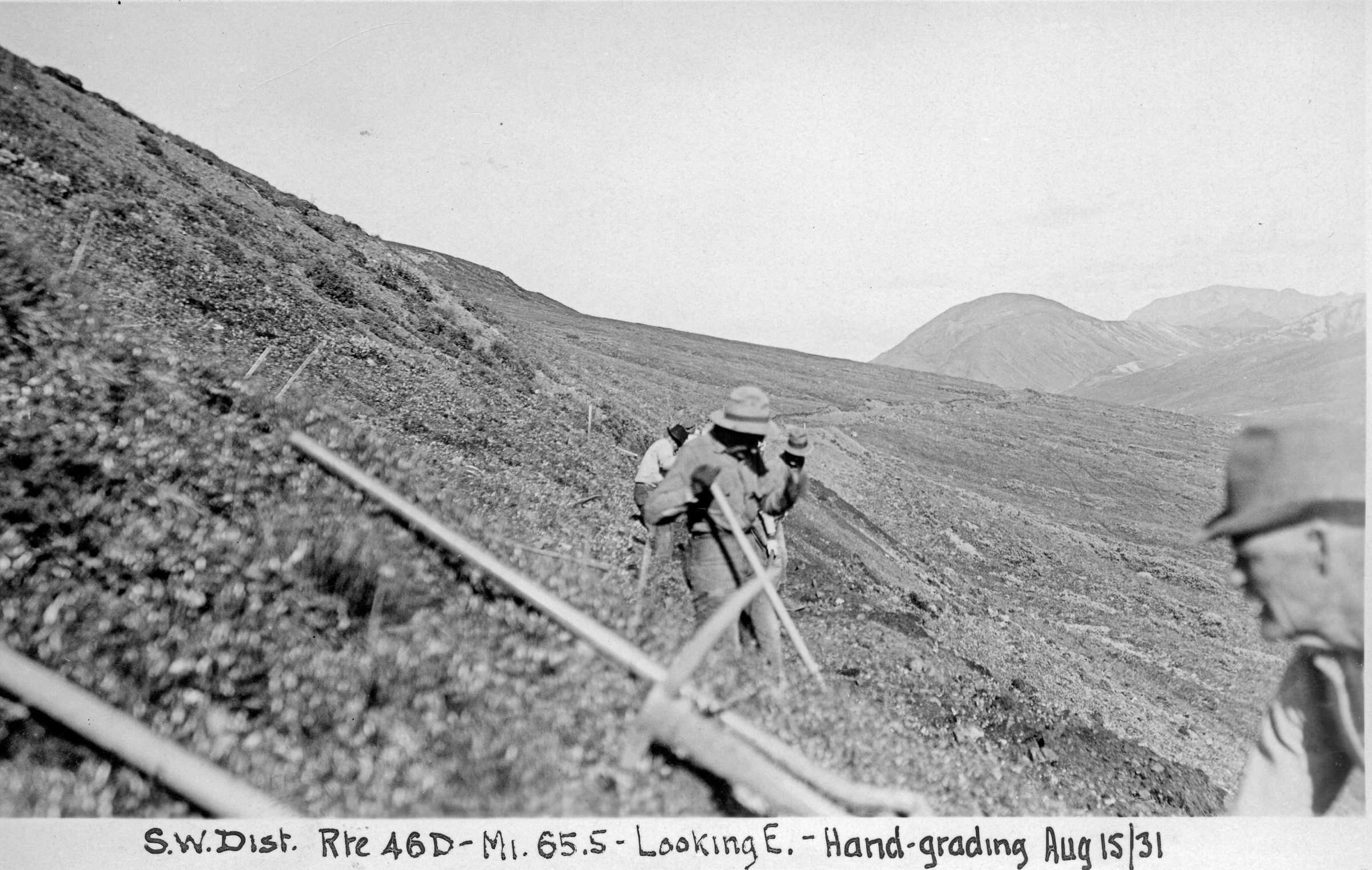
| 190 — | SW Dist. Rte. 46D, mi. 65.5, looking E, hand-grading, Aug. 15/31 [men with
shovels on tundra] |
| | 191 — | Rte. 46D, mile 66, “going down,” Sept. 2, 1932, SWD [automobile on steep
incline] |
| | 192 — | Rte. 46D, mile 66, looking E, Sept. 7, 1932, SW Dist. [men with equipment on
tundra, tent camp in distance. Same as .193] |
| | 193 — | Rte. 46D, mile 66, looking E, Sept. 7, 1932, SW Dist. [same as .192] |
| | 194 — | [on verso:] McKinley Park, mile 66, caught in rain [men with equipment. Image
damaged by rain drops] |
| | 195 — | McKinley Park Road, Route 46D, mile 62.3, looking south, 7-23-31, SW Dist.
[tractor on hillside, shovels in ground at left] |
| | 196 — | [on verso:] M. 68, Park, 46D [man standing next to two trucks stopped on road
in winter] |
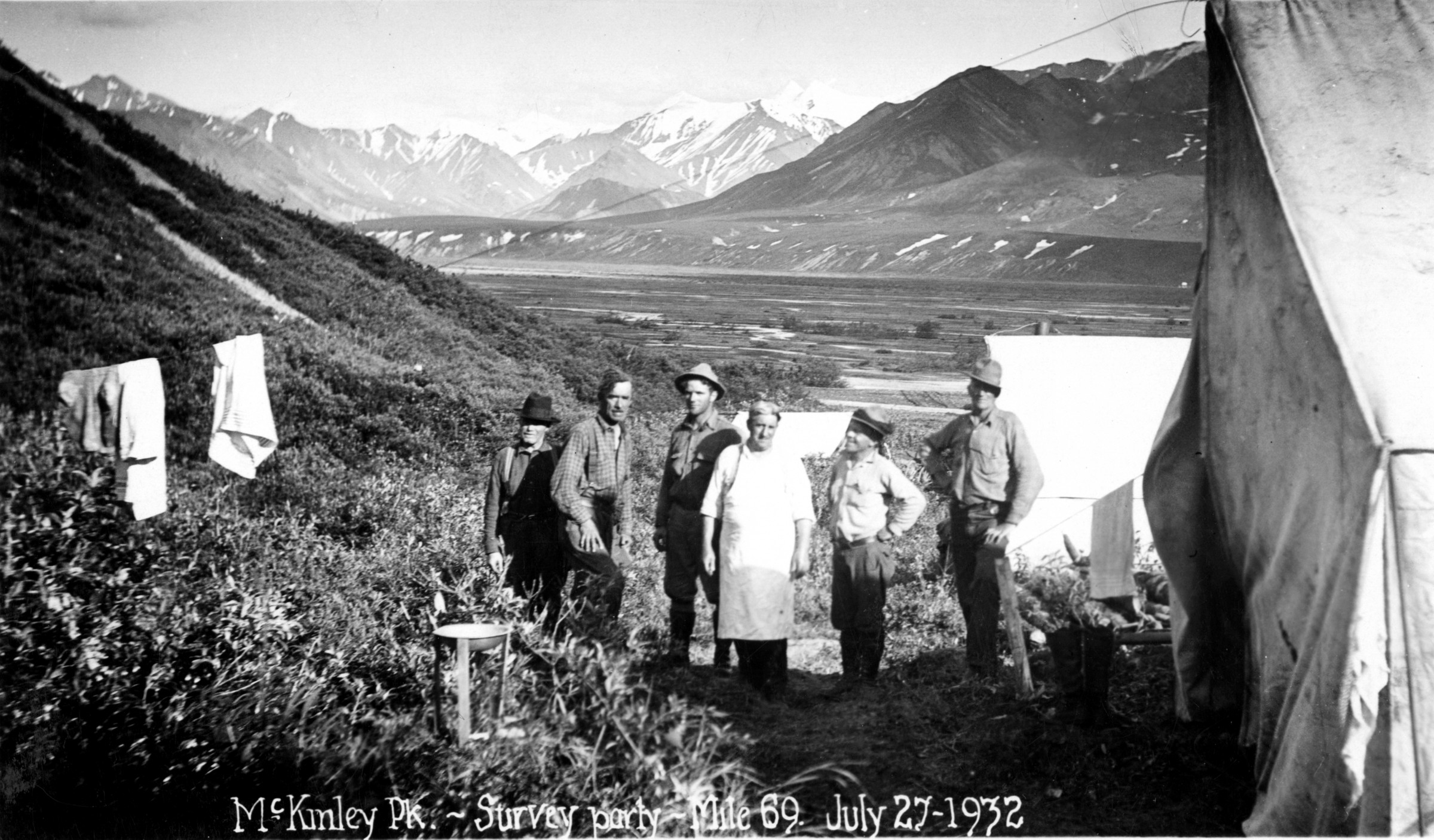
| 197 — | McKinley Pk., survey party, mile 69, July 27, 1932 [six men standing next to tents
on tundra, laundry on clothesline at left] |
| | 198 — | Rte. 46D, survey camp, mile 69, July 27, 1932, SW Distr. [tents along creek] |
| | 199 — | McKinley Park Road, Route 46D, mile 68, looking west, 7-14-31, SW Dist. [men
hand grading on tundra] |
| | 200 — | McKinley Park Road, Route 46D, mile 62.4, looking west, 7-23-31, SW Dist. [man
riding tractor pulling plow] |
| | 201 — | SW Dist. Rte. 46D, Mt. McKinley from mi. 62, July 15, 1931 [scenic] |
| | 202 — | McKinley Park Road, R. 46D, mile 62, looking east, 7-14-31, SW Dist. [view down
right-of-way on tundra. Same as .204] |
| | 203 — | SW Dist. Rte. 46D, mi. 63.2, July 15, ’31, looking E [distant view of equipment on
dirt road]
|
| | 204 — | McKinley Park Road, R. 46D, mile 62, looking east, 7-14-31, SW Dist. [same as
.202] |
| | 205 — | SW Dist. Rte. 46D, mi. 62, looking E, grading by hand, July 15, ’31 [men on
tundra] |
| | 206 — | McKinley Park Road, Route 46D, mile 62.3, looking south, 7-23-31, SW Dist.
[tractor on hillside] |
| | 207 — | Rte. 46D, mile 62.2, July 11, 1932, SW Distr. [horse-drawn wagon on road] |
| | 208 — | [on verso:] Mt. McKinley from mile 62.5, July 27, 1932 [scenic] |
| | 209 — | 228 – Mt. McKinley Park Road, McKinley Bar, Muldrow Glacier, Mt. Eielson, Kantishna,
Quigley Cabin. Route 46D |
| | 209 — | SW Dist. Rte. 46D, pk. Train, Mt. Eilson, July 28/31 [men on horseback with
packtrain on tundra near Mount Eielson] |
| | 210 — | Pack train, Mt. Eilson, 1931 [men and horses on tundra near Mount Eielson.
Same as .220] |
| | 211 — | Pk. Train, Mt. Eilson, July 28/31 [men on horseback with packtrain next to log
cabin near Mount Eielson] |
| | 212 — | SW Dist. Rte. 46D, Reconnaissance trip, Kantishna, July 30/31 [two men on
horseback with third horse] |
| | 213 — | SW Dist. Rte. 46D, Kantishna reconnaissance trip, lunch, July 28/31 [four men
and young woman picnicking, pack horses tied nearby] |
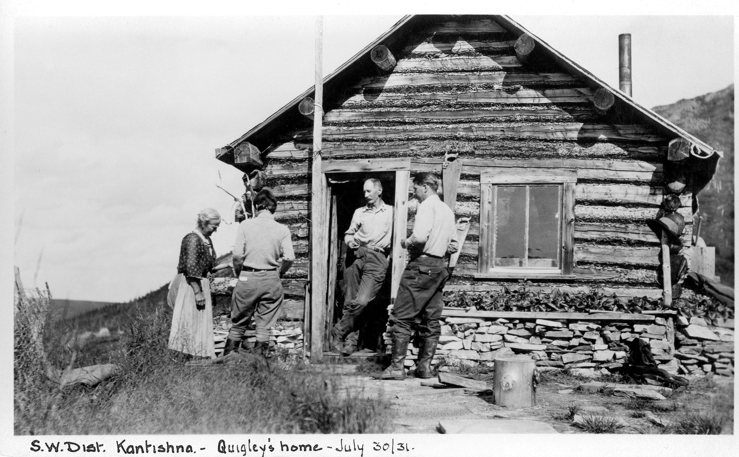
| 214 — | SW Dist., Kantishna, Quigley’s home, July 30/31 [three men and woman next to
log cabin, Fannie Quigley at left and Joe Quigley in doorway] |
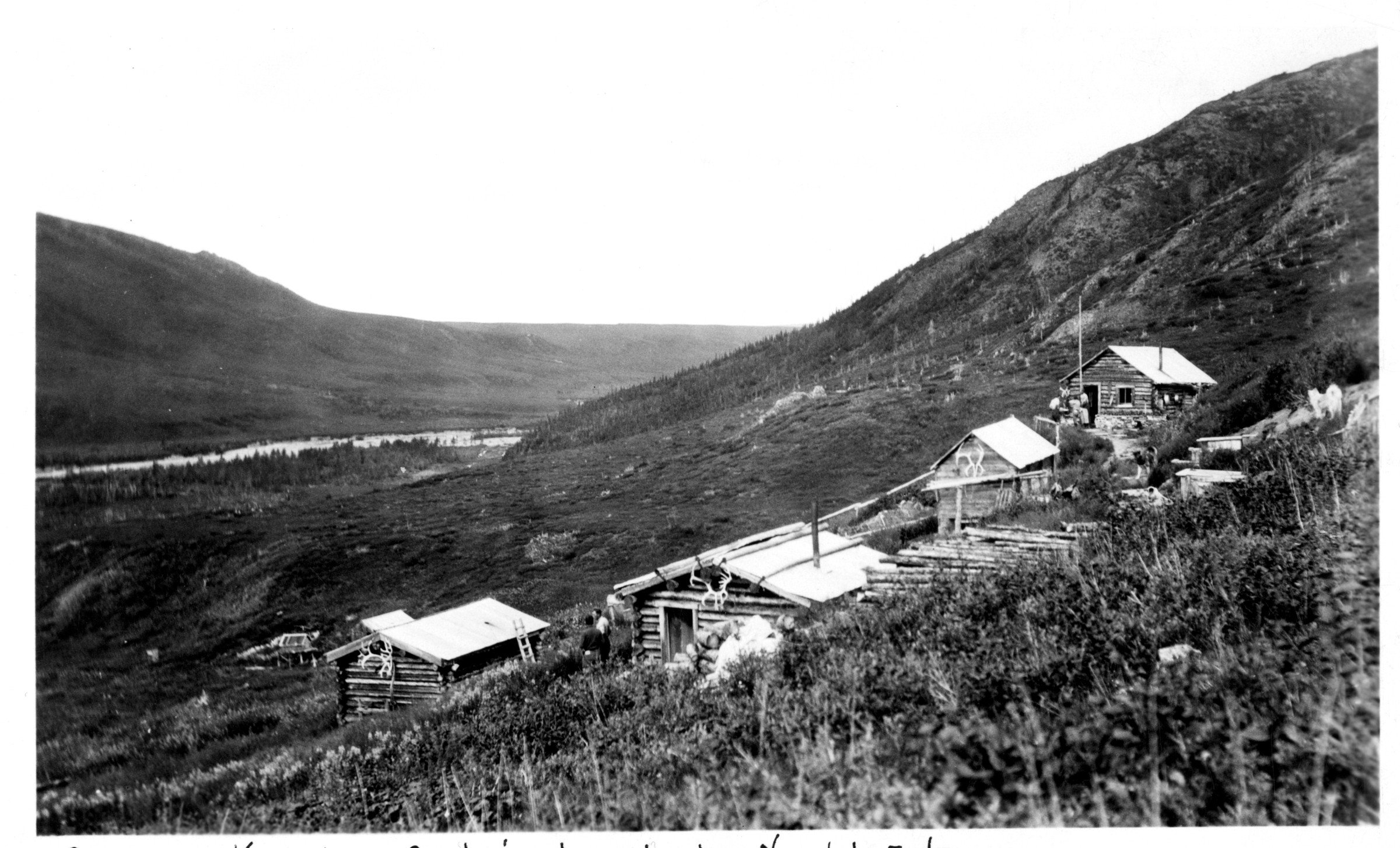
| 215 — | SW Dist., Kantishna, Quigley’s cabins, looking N, July 30/31 [bird’s eye view of
log cabins] |
| | 216 — | SW Dist., Kantishna, July 30/31 [four men and young woman posed on tundra,
Joe Quigley in center] |
| | 217 — | Crossing Moose Creek, Kantishna, Aug. 1931 [view of hillside, two people visible
in lower right foreground] |
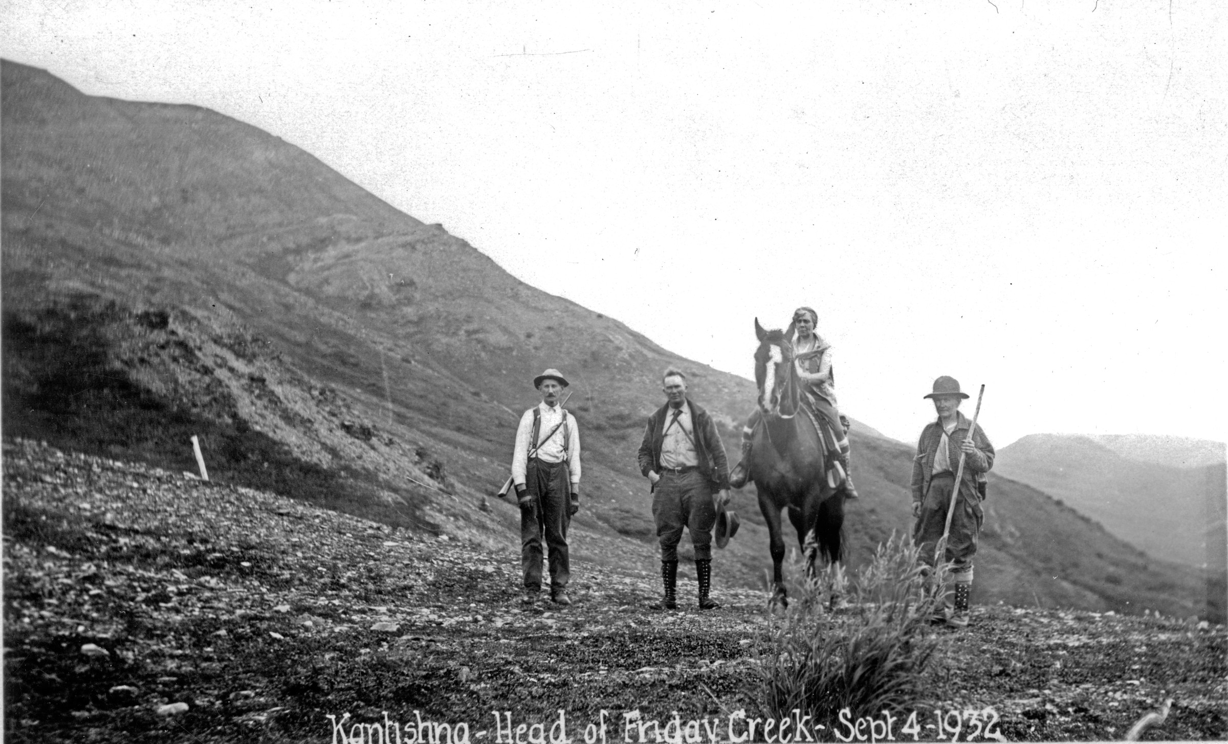
| 218 — | Kantishna, head of Friday Creek, Sept. 4, 1932 [on verso:] Quigley, Harry Leck,
Supt. of park, Betty Edmunds, Fannie Quigley [Quigleys and Harry Liek standing with
Edmunds on horseback] |
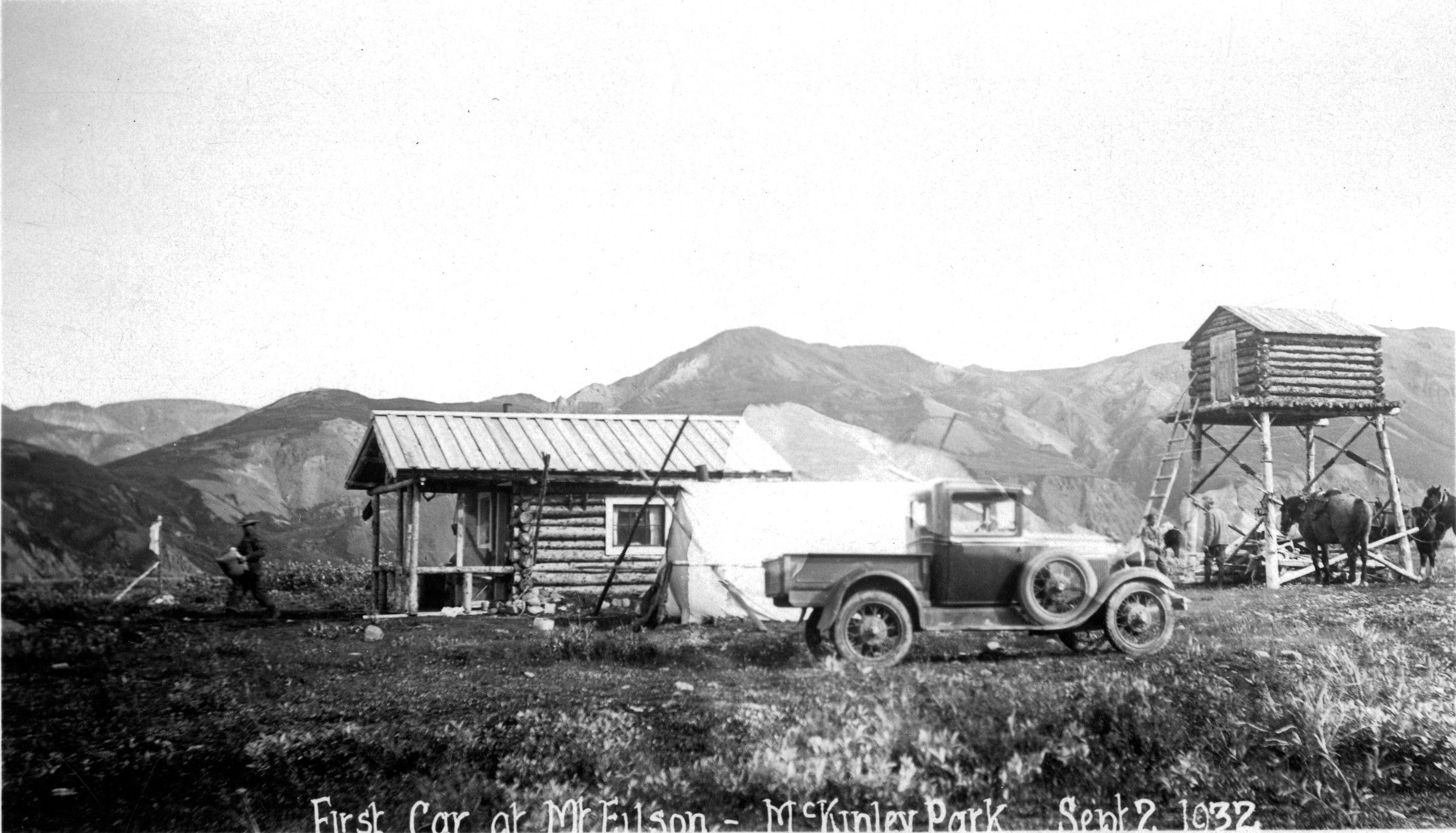
| 219 — | First car at Mt. Eilson, McKinley Park, Sept. 2, 1932 [truck parked in front of log
cabin and small tent, log cache at right, man walking at left, Mount Eielson] |
| | 220 — | Pk. train, Mt. Eilson, 1931 [same as .210] |
| | 221 — | SW Dist. Rte. 46D, Mt. McKinley from ft. Mt. Eilson, July 28/30 [horse packtrain
tied on tundra in foreground, mountain in distance] |
| | 222 — | Near Wonder Lake, Aug. 30/1931 [on verso:] Betty Edmunds, Harry Leek
[Edmunds and Harry Liek on horseback in forested area] |
| | 223 — | Mt. McKinley from McKinley bar, Sept. 5, 1932 [scenic] |
| | 224 — | Mt. McKinley from end of Muldrow Glacier, Sept. 6, 1932 [scenic] |
| | 225 — | Mt. McKinley from end of Muldrow Glacier, Sept. 6, 1932 [scenic] |
| | 226 — | SW Dist. Rte. 46D, looking across McKinley bar, south, July 28/31 [scenic] |
| | 227 — | McK. Park, lunch, McK. bar, Aug. 30/1931 [on verso:] Betty Edmunds, Harry Leek
[Edmunds and Harry Liek picnicking, two horses tied nearby]
|
| | 228 — | SW Dist. Rte. 46D, looking S across McKinley bar, July 28/31 [scenic] |
| | 229 — | 249 – Mt. McKinley Park Road, Animals - Moose, Bear, Squirrel, Sheep, Scenery, People,
Camps. Route 46D
.229 – [on verso:] Sheep, park, 46D [distant view of Dall sheep in winter]
.230 – [on verso:] Sheep, park, 46D [distant view of Dall sheep in winter]
.231 – [ptarmigan on rocks. Cf. .1031]
.232 – [distant view of animals on rock outcropping] |
| | 233 — | McKinley Park, squirrel, July 4, 1932 [ground squirrel in road, truck parked in
background] |
| | 234 — | [wolverine on snow patch on tundra] |
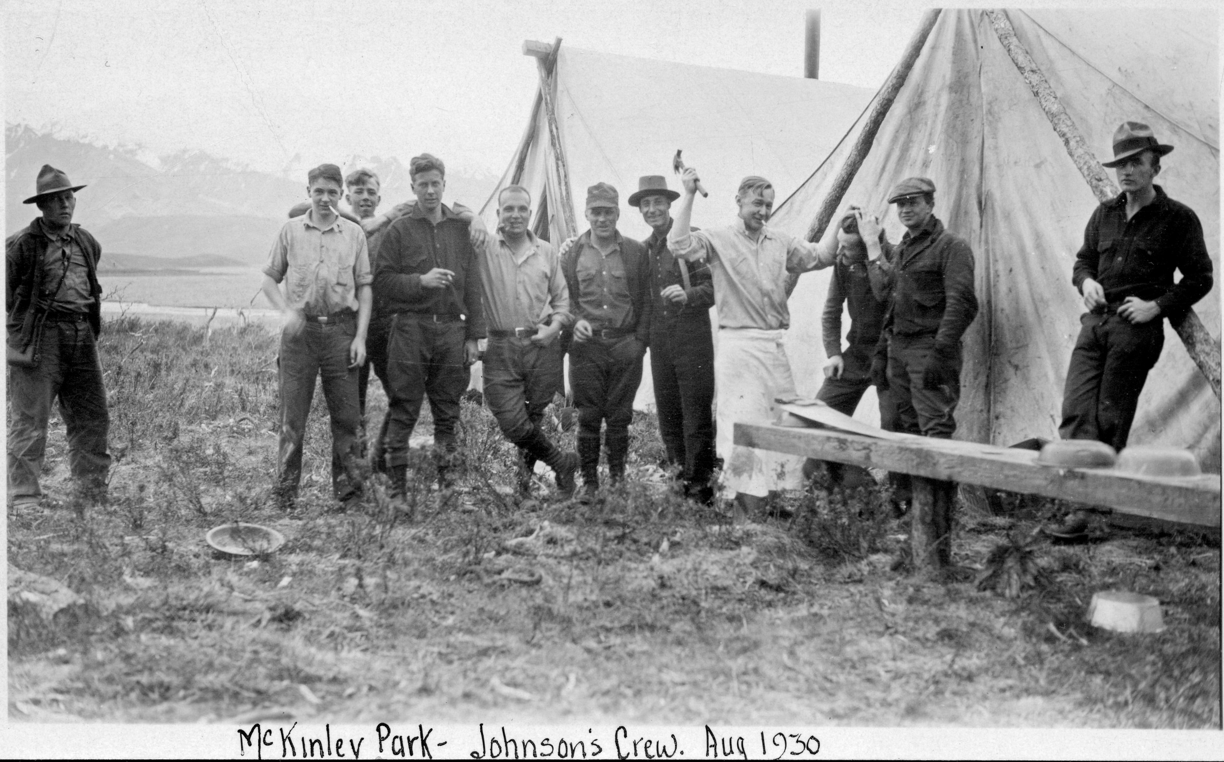
| | 235 — | [distant view of bull moose, tripod in foreground] |
| 236 — | McKinley Park, Johnson’s crew, Aug. 1930 [on verso:] 2
nd
on right, Harry Hoyt
[group of men posed next to tents, man wearing apron holding hammer as if to strike
another man] |
| | 237 — | McKinley Park road crew, mile [8?], Aug. 15, 1932 [six men seated on logs,
woman and three children at right, probably Edmunds family] |
| | 238 — | Eagle Summit, Sept. 30, 1936 [on verso:] Betty Edmunds [woman standing next
to sign reading “Elev. 3880”, Steese Highway] |
| | 239 — | 12 Mile Summit, Circle Rd., Sept. 30, 1936 [on verso:] Betty Edmunds [woman
standing next to signs reading “Circle 77” and “No Hunting, Twelve Mile Summit
caribou crossing,” Steese Highway] |
| | 240 — | Miners bridge across Cache Cr., June 1936 [simple log suspension bridge over
Cache Creek] |
| | 241 — | [high wooden bridge over river, probably McKinley Park Road] |
| 242 — | [bird’s eye view of large camp on tundra] |
| | 243 — | [on verso:] AK Rd Commission bldg. [automobile parked outside of building,
garage at left, Interior Alaska] |
| | 244 — | SW Dist. [illegible] mi. 7, May 1931 [person on dirt road] |
| | 245 — | [scenic of tundra] |
| | 246 — | SW Dist. Rte. 46D, hand grading [men with shovels working on road. Cf. .154] |
| | 247 — | Sept. 30, 1936 [on verso:] Morgan C. Edmunds, Supt. Alaska Road Commission
[man standing with pile of caribou antlers underneath sign reading “No Hunting,
Twelve Mile Summit caribou crossing,” Steese Highway] |
| | 248 — | SW Dist. Rte. 46D [illegible] [tent camp on tundra, with tent cache at left,
probably construction camp. Print overexposed] |
| | 249 — | [scenic of tundra, road in foreground] |
| | 250 — | 263 – Mt. McKinley Park Road, Miscellaneous equipment. Route 46D
.250 – McKinley Park, April 20, 1932 [equipment buried in snow at camp]
.251 – McKinley Park, April 20
th
, 1932 [three men posed with excavator in snow]
.252 – McKinley Park, April 20, 1932 [excavator on snow removal]
.253 – McKinley Park, 1931 [two men operating excavator on dirt road] |
| | 254 — | McKinley Park, April 20, 1932 [man posed with excavator in snow, second man
standing in deep snow at left] |
| | 255 — | [horse-drawn wagon mired in snow on tundra]
|
| 256 — | [man posed with equipment on right-of-way, with excavator and Ingersoll-Rand
generator, river valley in background] |
| | 257 — | [supply convoy, with tractor pulling sleds, equipment in snow at right, dog at
left] |
| | 258 — | [tractor operating in valley in winter] |
| | 259 — | [tractor pulling walled tent on sled over tundra] |
| | 260 — | [bulldozer working on hillside] |
| | 261 — | [men operating tractors on tundra, supply sled in background] |
| | 262 — | [man operating tractor-pulled grader on slope] |
| | 263 — | [bridge construction, with crane] |
| | 264 — | 272 – Iliamna Area, Road building in general. Route 48, miles 2-10
.264 – SW Dist. Rte. 48, mi. 2, looking S, Sept. 14/31 [view down road through pass] |
| | 265 — | SW Dist. Rte. 48, mi. 2, looking NW, Sept. 14, ’31 [view down newly graded road
through pass] |
| | 266 — | SW Dist. Rte. 48, mi. 2.1, looking NW, Sept. 14/31 [view down road through
pass, possibly Summit Lakes in distance] |
| | 267 — | SW Dist. Rte. 48, mi. 5.5, looking SE, Sept. 14/31 [view down rutted track
through mountainous area] |
| | 268 — | Rte. 48, Iliamna camp, mile 7, Oct. 1933, SW Dist. [tents in brush next to creek] |
| | 269 — | Rte. 48, mile 8, Iliamna, Oct. 1933, SW Dist. [man standing on dirt road] |
| | 270 — | Rte. 48, mile 8, Iliamna, Oct. 1933, SW Dist. [view down dirt road,
photographer’s shadow in foreground] |
| | 271 — | Rte. 48, mile 10, Iliamna, Oct. 1933, SW Dist. [view down dirt track] |
| | 272 — | Rte. 48, mile 10, Iliamna, Oct. 1933, SW Dist. [men tying logs together, possibly
for bridge] |
| | 273 — | 288 – Talkeetna/Cache Creek Area, Talkeetna Camp, Talkeetna Road Crew, Bridges,
Roadhouses. Route 51, miles 2-23.5 |
| | 273 — | Rte. 51, camp at river, mile 2, June 22, 1932, SW Distr. [view down road to tents
and equipment next to wooden building] |
| | 274 — | Talkeetna, road crew at mile 2, June 22, 1932 [eight men and one woman posed
on riverbank, three men wearing mosquito netting, metal barrels at right, tarped
supplies at left] |
| | 275 — | Rte. 51, in mile 3, June 22, SW Distr. [view down dirt road through forested
area] |
| | 276 — | Rte. 51, mile 3, gravel pit, June 22, 1932, SW Distr. [pit in trees] |
| | 277 — | SW Dist. Rte. 51, mi. 5.5, Talkeetna-Cache Creek, looking E, July 15/31 [view
down muddy tracks through forested area] |
| | 278 — | Rte. 51, mile 7, looking east, June 11, 1936, SW Distr. [view down dirt road in
forested area] |
| | 279 — | Rte. 51, mile 8, looking east, July 1, 1934, SW Dist. [view down dirt road in
forested area] |
| | 280 — | SW Dist. Rte. 51, mi. 9.5, showing beaver activity [view down road to downed
trees and flooded area]
|
| | 281 — | SW Dist. Rte. 51, Talkeetna-Cache Cr., mi. 9.5, looking E, July 16, ’31 [view down
road to two sections of log bridge or corduroy] |
| | 282 — | SW Dist. Rte. 51, mi. 9.5, showing beaver activity, Aug. 10/31 [view down road
to flooded area] |
| | 283 — | SW Dist. Rte. 51, mi. 12, July 15, 1931 [view down dirt road through forested
area] |
| | 284 — | SW Dist. Rte. 51, mi. 18 ½, [Croto?] Creek bridge [log truss bridge, possibly Kroto
Creek] |
| | 285 — | SW Dist. Rte. 51, mi. 18 ½, Croto Creek bridge, July 15/31 [log truss bridge at
Kroto Creek] |
| | 286 — | SW Dist. Rte. 51, mi. 23 ½, Peters Cr. bridge, Aug. 10, ’31 [truss bridge over
Peters Creek] |
| | 287 — | Rte. 51, roadhouse, mile 23 ½, June 9, 1936, SW Distr. [log roadhouse near
Peters Creek, probably Forks Roadhouse] |
| | 288 — | SW Dist. Rte. 51, mi. 23 ½, Peters Creek, looking E, July 15/31 [bird’s eye view of
wooden bridge, possibly roadhouse or homestead on far bank] |
| | 289 — | 304 – Talkeetna/Cache Creek Area, Moose Creek Bridge, Landing at Talkeetna, Lower
Cache Creek Camp, Lower Cache Creek Area. Route 51
.289 – [missing]
.290 – Rte. 51, Moose Creek bridge, June 1931 [wooden bridge] |
| | 291 — | SW Dist. Rte. 51, Talkeetna-Cache Cr., Moose Cr. bridge, mi. [illegible], July
[illegible], ’31 [wooden bridge] |
| | 292 — | SW Dist. Rte. 51, Talkeetna-Cache Cr., tractor on W bank, July 16, ’31 [view
across water to equipment on far bank] |
| | 293 — | SW Dist. Rte. 51, mi. 12, [illegible] [view along riverbank to wooden bridge] |
| | 294 — | [on verso:] Rte. 51, Talkeetna, June 1931 [tractor pulling wagon on dirt road,
man wearing mosquito netting standing at right] |
| | 295 — | Warehouse #12 at landing, Talkeetna, R. 51, SW Dist. [wooden building with
“Alaska Road Commission” sign in winter] |
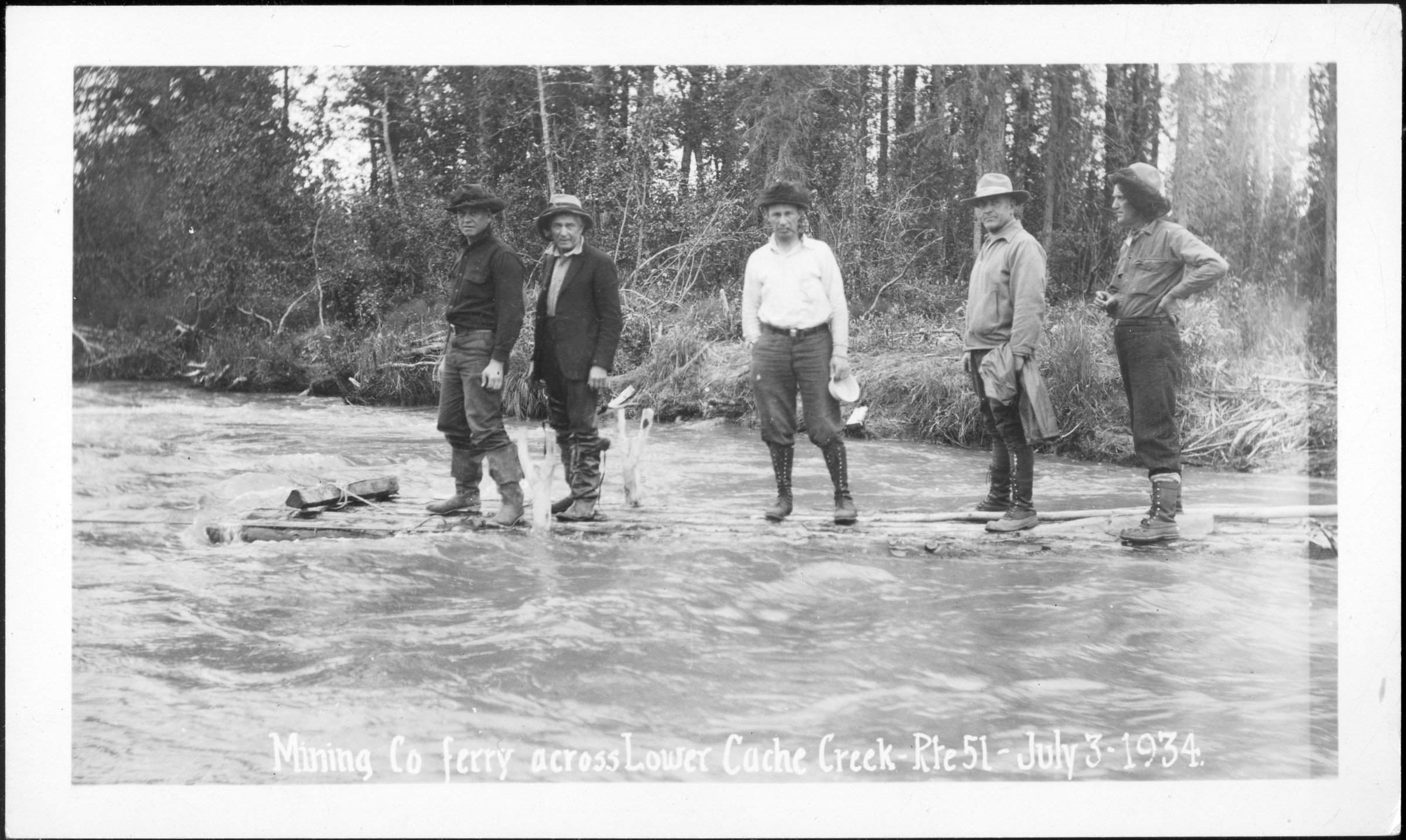
| 296 — | Mining co. ferry across Lower Cache Creek, Rte. 51, July 3, 1934 [five men
standing on small wooden raft] |
| | 297 — | Rte. 51, Lower Cache Creek, looking SW, July 3, 1934, SW Dist. [scenic
overlooking forested valley] |
| | 298 — | Camp site, prospective dredge, Lower Cache Creek, July 2, 1934, SW Dist.
[walled tents in clearing] |
| | 299 — | Prospecting hand-drill, Lower Cache Creek, Rte. 51, July 3, 1934, SW Dist. [men
working at base of large wooden tripod in wooded area] |
| | 300 — | Prospecting hand-drill, Lower Cache Creek, Rte. 51, SW Dist., July 3, 1934 [men
with large wooden tripod in wooded area] |
| | 301 — | Talkeetna, hydraulic pipe [illegible], Cache Cr. ([illegible]), June 1936 [pipeline
crossing creek on small wooden bridge, probably for hydraulic mining operation] |
| | 302 — | Ptarmigan, Cache Creek, July 4, 19334 [hat resting on low brush] |
| | 303 — | Talkeetna, Lower Cache Cr., camp, Morgan & Co., June 1936 [view through trees
to walled tents and log cache, Cache Creek Mining Co. camp]
|
| | 304 — | Talkeetna, fording Lower Cache Cr., June 10, 1936 [man walking waist-deep in
creek] |
| | 305 — | 317 – Peters Creek Area (Talkeetna), Peters Creek Trail, Peters Creek Bridge, Spruce
Creek Shelter Cabin. Routes 51, 51D |
| | 305 — | [on verso:] Peters Cr. Mg. Co.’s cat on trail, 6-7 mile, Aug. 1931 [two men riding
tractor on trail in forested area] |
| | 306 — | [on verso:] Camp on Peters Cr. trail, mile 6, Aug. 1931 [bird’s eye view of three
tents on taiga, man walking through brush in foreground] |
| | 307 — | [on verso:] Peters Cr. trail, 7 mile to 8, Aug. 1931 [view down trail through taiga] |
| | 308 — | [on verso:] Peters Cr. trail at 5 mile, Aug. 1931, Deep Cr. Hill [man standing on
trail. Print faded] |
| | 309 — | Peters Creek, Oct. 13, 1931 [man riding small tractor in shallow creek, man
standing at left, placing logs for bridge] |
| | 310 — | [on verso:] Peters Cr. trail at mile 8, Aug. 1931 [trail in forested area. Print
faded] |
| | 311 — | Peters Creek, Talkeetna, Oct. 1931 [man and woman standing in front of
wooden building with “Alaska Road Commission” sign, splitting firewood] |
| | 312 — | SW Dist. Rte. 51, Peters Cr. bridge, Oct. 22, 1931 [ladder against pier of truss
bridge] |
| | 313 — | SW Dist. Rte. 51, Peters Cr. bridge, Oct. 22, 1931 [men working around pier of
truss bridge] |
| | 314 — | SW Dist. Rte. 51, Peters Cr. bridge, Oct. 13, 1931 [man operating tractor in creek
next to truss bridge] |
| | 315 — | SW Dist. Rte. 51, Peters Cr. bridge, Oct. 12, 1931 [men working around pier of
truss bridge] |
| | 316 — | SW Dist. Rte. 51, Peters Cr. bridge, Oct. 21, 1931 [men standing in creek next to
truss bridge] |
| | 317 — | Rte. 51D, Spruce Cr., shelter cabin, June 11, 1936, SW Distr. [log cabin near
Spruce Creek] |
| | 318 — | 345 – Peters Creek Trail (Talkeetna), Peters Creek Trail, Road clearing, Scenery,
Equipment. Route 51B, miles 3-14
.318 – Rte. 51B, mile 3, looking north, June 11, 1936, SW Distr. [view down dirt road]
.319 – SW Dist. Rte. 51B, mi. 5, Peters Creek [view down muddy track in forested area] |
| | 320 — | SW Dist. Rte. 51B, mi. 5, looking N, Aug. 10/31 [tractor mired in muddy track in
forested area] |
| | 321 — | SW Dist. Rte. 51B, mi. 4.5, crossing swamp, Aug. 10, ’31 [view across bog to
tractor on far side] |
| | 322 — | [on verso:] SW Rte. 51B, soft trail mi. 6, July 15/31 [two men with equipment in
bog. Print faded] |
| | 323 — | Rte. 51B, mile 7, stripping, July 2, 1936, SW Dist. [man using tractor to clear
brush] |
| | 324 — | Rte. 51B, mile 7, grubbing, July 2, 1936, SW Dist. [man using tractor to clear
brush]
|
| | 325 — | [on verso:] Peters Creek Trail, m. 12, 51B, Sep. 1933 [trail along mountainside in
pass area] |
| | 326 — | [on verso:] Peters Creek Trail, 51B, m. 12, Sep. 1933 [trail along mountainside in
pass area] |
| | 327 — | [on verso:] Peters Creek Trail, 51B, m. 12, Sep. 1933 [trail along mountainside in
pass area] |
| | 328 — | SW Dist. Rte. 51B, Peters Cr. Placer Co., mi. 12, July 16, ’31 [water pipeline
running across ground to equipment in clearing, Peters Creek Placer Co.] |
| | 329 — | Rte. 51B, looking S from mile 12.5, Sept. 16, 1932, SW Distr. [scenic overlooking
valley] |
| | 330 — | Rte. 51B, mile 13, 1933, SW Dist. [men using shovels to clear trail along
mountainside] |
| | 331 — | [on verso:] Peters Creek Trail, m. 13, 51B, Sep. 1933 [trail along mountainside] |
| | 332 — | Rte. 51B, mile 13, 1933, SW Distr. [trail along mountainside] |
| | 333 — | [on verso:] Peters Creek Trail, m. 13, 51B, Sep. 1933 [bird’s eye view of river
canyon] |
| | 334 — | [on verso:] Peters Creek Trail, m. 13, 51B, Sep. 1933 [trail along mountainside] |
| | 335 — | Rte. 51B, mile 13, looking S, Sept. 16/32, SW Distr. [men using shovels to clear
trail along mountainside] |
| | 336 — | SW Rte. 51B, mi. 4, crossing swamp, Aug. 10/31 [distant view of tractor in bog] |
| | 337 — | [on verso:] Peters Creek Trail, m. 14, 51B, Sep. 1933 [trail along mountainside] |
| | 338 — | Rte. 51B, mile 14, showing rock, Sept. 18, ’32, SW Distr. [view down trail along
mountainside] |
| | 339 — | Rte. 51B, mile 14, Sept. 16/32, SW Distr. [view down trail along mountainside] |
| | 340 — | SW Dist. Rte. 51B, Peters Creek Mining Co. operations, Aug. 10/31 [view across
river to hydraulic mining operation, with excavator, monitor and tractor] |
| | 341 — | Rte. 51B, drag-line, Peters Creek, June 11, 1936, SW Distr. [dragline excavator
bucket emptying into mining plant] |
| | 342 — | Rte. 51B, drag-line, Peters Creek, June 11, 1936, SW Distr. [Bucyrus Erie dragline
excavator and mining plant] |
| | 343 — | Rte. 51B, drag-line, Peters Cr., June 11, 1936, SW Distr. [three men posed with
Bucyrus Erie excavator, another man on machine above] |
| | 344 — | Rte. 51B, bulldozer working on tailings, June 1936, SW Distr. [bird’s eye view
from mining plant over tailings piles] |
| | 345 — | Rte. 51B, Petersville, June 11, 1936, SW Distr. [bird’s eye view of buildings along
dirt road] |
| | 346 — | 351 – Anchorage Area, Equipment - V – Plow. Route 75, miles 13-19 |
| | 346 — | V-plow, Route 75, mile 13, Feb. 19, 1932, SW Dist. [man walking next to
snowplow on road, possibly transformer at left, buildings at right, Chugach Mountains
in background] |
| | 347 — | V-plow, Route 75, mile 13, Feb. 15, 1932, SW Dist. [snowplow on road, possibly
transformer at left, buildings at right, Chugach Mountains in background] |
| | 348 — | V-plow, Route 75, mile 14, Feb. 19, 1932, SW Dist. [snowplow on road through
taiga]
|
| | 349 — | V-plow, Route 75, mile 15, Feb. 15, 1932, SW Dist. [snowplow on road,
automobile next to utility pole in background] |
| | 350 — | Rte. 75, mile 18.5, Sept. 29/32, SW Distr. [view down gravel road] |
| | 351 — | Rte. 75, plowing snow, Mar. 1933, mile 19, SW Dist. [man operating LaPlant-
Choate snowplow on road through taiga] |
| | 352 — | 362 – Anchorage Area, D.A.R. Mile Marker, Equipment. Route 75L, miles 0-8.5 |
| | 352 — | Rte. 75L, D.A.R. marker, mile 0, June 20, 1936, SW Distr. [stone marker placed by
Alaska Chapter, Daughters of the American Revolution] |
| | 353 — | Rte. 75L, mile 1, June 24, 1933, SW Dist. [view down dirt road] |
| | 354 — | Rte. 75L, mile 1.5, Eagle R. Rd., June 30, 1934, SW Dist. [two men on tractor
pulling grader] |
| | 355 — | Anch. Matanuska Road, mile 2, Sept. 1934 [view down dirt road] |
| | 356 — | Rte. 75L, Eagle R. Rd., mile 2, June 30, 1934, SW Dist. [tractor pulling grader] |
| | 357 — | Rte. 75L, Eagle R. Rd., mile 2, June 30, 1934, SW Dist. [tractor pulling grader] |
| | 358 — | Rte. 75L, Anch.-Matanuska Rd., mile 9.5, Sept. 1933, SW Dist. [men with shovels
working on road, one man wearing mosquito netting] |
| | 359 — | Rte. 75L, mile 8, Sept. 1933, SW Dist. [view down dirt road] |
| | 360 — | Rte. 75L, mile 8, Anch.-Matanuska Rd., Sept. 1933, SW Dist. [view down dirt
road] |
| | 361 — | Rte. 75, mile 18.5, Sept. 29/32, SW Dist. [view down dirt road] |
| | 362 — | Rte. 75L, Anch.-Matanuska Rd., camp #1, mile 8.5, Sept. 1933, SW Dist. [view
down dirt road, tents on either side of road in distance] |
| | 363 — | 387 – Eagle River to Knik River, Eagle River Bridge, Peters Creek Bridge, Knik River Bridge,
1936. Route 75L |
| | 363 — | Rte. 75L, temporary crossing, Eagle R. bridge, Oct. 1933, SW Dist. [bird’s eye
view of men placing logs across Eagle River, sawhorses and pier form in foreground] |
| | 364 — | Rte. 75L, Eagle R. bridge, Dec. 1933, SW Dist. [truss bridge over Eagle River, men
on ice below] |
| | 365 — | Rte. 75L, south pier, Eagle R. bridge, Oct. 1933, SW Dist. [view down river to
bridge construction in winter] |
| | 366 — | Rte. 75L, ferry, Eagle River, Sept. 1933, SW Distr. [man in boat, pulling across
river] |
| | 367 — | Rte. 75L, Eagle R. bridge, Nov. 17, 1933, SW Dist. [bird’s eye view of bridge
construction in winter] |
| | 368 — | Rte. 75L, ½ mi. north Eagle R. bridge, Oct. 1933, SW Dist. [view down dirt road] |
| | 369 — | Rte. 75L, runway Eagle R. gravel-pit, Eagle R. bridge, Oct. 1933, SW Dist. [man
walking on wooden planks along riverbank in winter] |
| | 370 — | Rte. 75L, form, south pier, Eagle R. bridge, Oct. 1933, SW Dist. [men working on
form] |
| | 371 — | Rte. 75L, Peters Creek bridge, mile 15 ½, Apr. 1934, SW Dist. [wooden truss
bridge on log piers] |
| | 372 — | Rte. 75L, Peters Creek bridge, mile 15 ½, Apr. 1934, SW Dist. [wooden truss
bridge under construction]
|
| | 373 — | [on verso:] Peters Creek camp from south, 75L, Oct. 3, 1933 [view down gravel
road to burning brush, tents on flat in far distance left background] |
| | 374 — | [on verso:] Grade, south Peters Creek camp, 75L, Oct. 1933 [view down gravel
road, burning brush at left] |
| | 375 — | [on verso:] Temporary bridge, Peters Creek, 75L, Sep. 1933 [bird’s eye view of
log bridge across river, men working next to tractor on far bank] |
| | 376 — | [on verso:] Camp, Peters Creek, 75L, Sep. 1933 [three men standing next to
several tents in clearing, drying rack in foreground] |
| | 377 — | Rte. 75L, Peters Creek bridge, mile 15 ½, Apr. 1934, SW Dist. [view across
cleared land to small bridge, tents in distance] |
| | 378 — | Rte. 75L, Peters Creek bridge, mile 15 ½, Apr. 1934, SW Dist. [small bridge under
construction, with log pier] |
| | 379 — | Rte. 75L, Peters Creek bridge, mile 15 ½, Apr. 1934, SW Dist. [small bridge under
construction] |
| | 380 — | P-126. Hewitt’s [Knik River bridge under construction, automobile in
foreground. Same image as B1989.016.1090.2] |
| | 381 — | P-125. Hewitt’s [Knik River bridge under construction. Same image as
B1989.016.1098] |
| | 382 — | Rte. 75L, loading rock, Knik R. bridge, July 18, 1936, SW Distr. [boulder
suspended from cable being lowered into truck on road, man standing at right] |
| | 383 — | Rte. 75L, loading rock, Knik Bridge, July 18, 1936, SW Distr. [dump truck
dumping boulders onto pile] |
| | 384 — | Rte. 75L, Knik River during annual flood, Aug. 19, 1936, SW Distr. [distant view
of bridge, man standing on raised roadbed] |
| | 385 — | Rte. 75L, loading gravel off Knik R. bar, July 18, 1936, SW Distr. [excavator
dumping rock into two dump trucks] |
| | 386 — | Rte. 75L, mile 31.4, during annual flood Knik River, Aug. 19, 1936, SW Distr.
[automobile on road next to flooded area in woods] |
| | 387 — | Rte. 75L, mile 29.3, during annual flood Knik R., Aug. 19, 1936, SW Distr. [view
down road to flooded area in woods] |
| | 388 — | 412 – Matanuska River Bridge, Bridge construction. Route 75L |
| | 388 — | Rte. 75L, Matanuska Bridge, Palmer, Jan. 1934 [view down ice to pile driver at
construction site] |
| | 389 — | Rte. 75L, Matanuska R. Bridge, Palmer, Feb. 1934 [view down bridge deck to
men working, hoses on ground in foreground] |
| | 390 — | 75L, N pier, Matanuska Bridge, Feb. 1934 [view down ice to pile driver at
construction site] |
| | 391 — | Matanuska Bridge, bridge seat and bulkhead, S end, 75L, Jan. 1934 [man
working at construction site] |
| | 392 — | Rte. 75L, Matanuska R. Bridge, Palmer, Feb. 1934 [men working on bridge deck] |
| | 393 — | Rte. 75L, N end from W Matanuska Bridge, 1934 [view down ice to bridge, with
pile driver] |
| | 394 — | Rte. 75L, N Pier, Matanuska Bridge, Feb. 1934 [pile driver at construction site]
|
| | 395 — | Rte. 75L, Matanuska Br., Palmer, Feb. 1934, SW Dist. [men working on bridge
construction] |
| | 396 — | View from S end Matanuska River Bridge, 1934 [view across bridge in winter,
men in foreground and on deck in distance] |
| | 397 — | Rte. 75L, Matanuska Bridge, approach to N pier, Jan. 1934, SW Dist. [pile driver
at left, ladder to top of concrete pier at right] |
| | 398 — | Rte. 75L, N pier and falsework, Matanuska Bridge, Jan. 1934, SW Dist. [steam
and ice at construction site] |
| | 399 — | Rte. 75L, N pier, Matanuska Bridge, Feb. 1934, SW Dist. [pier under
construction] |
| | 400 — | Rte. 75L, false-work, Matanuska Bridge, Jan. 1934 [view from ice of underside of
bridge under construction] |
| | 401 — | Rte. 75L, N pier and falsework, Matanuska Bridge, Jan. 1934, SW Dist. [distant
view of bridge construction] |
| | 402 — | Rte. 75L, Matanuska R. Bridge, Palmer, Feb. 1934, SW Dist. [men working on
bridge deck] |
| | 403 — | Rte. 75L, Matanuska Bridge, Palmer, Feb. 1934, SW Dist. [close-up of bridge
deck] |
| | 404 — | Rte. 75L, Palmer Br., Matanuska R., Feb. 1934, SW Dist. [close-up of deck] |
| | 405 — | Showing camber blocking etc., Matanuska Br. [view across bridge under
construction] |
| | 406 — | Rte. 75L, Matanuska Bridge, Palmer, Jan. 1934, SWD, false-work camber
blocking [view across bridge under construction] |
| | 407 — | Rte. 75L, unloading steel, Matanuska Bridge, Jan. 1934 [distant view of men next
to steel beams on ground] |
| | 408 — | Rte. 75L, Matanuska Bridge, south pier, Jan. 1934, SW Dist. [beams holding
earth in place along riverbank] |
| | 409 — | Rte. 75L, Matanuska Bridge, pouring concrete, Jan. 1934, SW Dist. [blurred
image of men at work] |
| | 410 — | Rte. 75L, Matanuska Bridge, N pier, Jan. 1934, SW Dist. [man working next to
concrete pier] |
| | 411 — | Rte. 75L, Matanuska Bridge, pouring concrete, Jan. 1934 [blurred image of men
at work] |
| | 412 — | Rte. 75L, Matanuska River, false-work with camber blocking, Jan. 1934, SW Dist.
[view across bridge under construction] |
| | 413 — | 430 – Matanuska River Bridge, Bridge construction, Completed bridge. Route 75L
.413 – Rte. 75L, Matanuska Bridge, Feb. 1934, SW Dist. [bird’s eye view of bridge] |
| | 414 — | Rte. 75L, Matanuska Bridge, Feb. 1934, SW Dist. [view across bridge deck under
construction]
.415 – East side bridge, 75L, Feb. 1934 [truss being erected]
.416 – Rte. 75L, Matanuska Bridge, Feb. 1934, SW Dist. [truss being erected] |
| | 417 — | Raising top chord, Matanuska Bridge [on verso:] 75L, Feb. 1934 [truss being
erected]
|
| | 418 — | Rte. 75L, Matanuska Bridge, raising top chord, Feb. 1934, SW Dist. [truss being
erected |
| | 419 — | Rte. 75L, Matanuska Bridge, raising top chord, Feb. 1934, SW Dist. [truss being
erected] |
| | 420 — | Rte. 75L, Matanuska Bridge, Mar. 1934, SW Dist. [view from riverbank to bridge
construction, one truss erected, men on deck above log pier at left] |
| | 421 — | Rte. 75L, view of Matanuska Bridge from west, Feb. 14, 1934 [view down ice to
trusses being erected, photographer’s shadow in foreground] |
| | 422 — | Rte. 75L, from S end Matanuska River Bridge, 1934 [view from riverbank, man
atop truss at left, men and equipment on ice below] |
| | 423 — | Rte. 75L, Matanuska Bridge, Feb. 1934, SW Dist. [view down river, bridge in far
distance] |
| | 424 — | Rte. 75L, view downstream, Matanuska Bridge, Feb. 1934, SW Dist. [view down
river, bridge in distance] |
| | 425 — | Rte. 75L, view upstream, Matanuska Bridge, Mar. 1934, SW Dist. [view down
river] |
| | 426 — | Rte. 75L, Matanuska Bridge, Mar. 1934, SW Dist. [view across bridge deck] |
| | 427 — | 75L, Matanuska Bridge, Feb. 1934 [view across bridge deck] |
| | 428 — | Rte. 75L, view upstream, Matanuska Bridge, Mar. 1934, SW Dist. [view down
river] |
| | 429 — | Rte. 75L, view upstream, Matanuska Bridge, Mar. 1934, SW Dist. [view down
river] |
| | 430 — | Rte. 75L, view upstream, Matanuska Bridge, Mar. 1934, SW Dist. [view down
river] |
| | 431 — | 444 – Matanuska River Area, Matanuska Bridge Camp, Equipment, People. Route 75L |
| | 431 — | Rte. 75L, camp, Matanuska Bridge, Feb. 1934, SW Dist. [bird’s eye view of tents
in trees] |
| | 432 — | Rte. 75L, camp at Matanuska Bridge, Dec. 1933, SW Dist. [bird’s eye view of
tents in trees] |
| | 433 — | Rte. 75L, camp, Matanuska Bridge, Feb. 1934, SW Dist. [tents in trees] |
| | 434 — | Rte. 75L, Matanuska Bridge, Dec. 1933, SW Dist. (These pumps failed to work)
[view across snow to small building at equipment at right, tents in background] |
| | 435 — | Rte. 75L, moving piledriver, completion steel, Matanuska Bridge, Feb. 1934 [pile
driver being raised to bridge deck] |
| | 436 — | Rte. 75L, moving piledriver, completion steel, Matanuska Bridge, Feb. 1934, SW
Dist. [pile driver being raised to bridge deck] |
| | 437 — | Rte. 75L, moving piledriver, Matanuska Bridge, Feb. 1934, SW Dist. [view down
railroad tracks to pile driver] |
| | 438 — | Rte. 75L, loading pile driver, Matanuska Bridge, Feb. 1934 [pile driver being
raised] |
| | 439 — | Rte. 75L, moving boiler, Matanuska Bridge, Feb. 1934, SW Dist. [tractors pulling
boiler on sled] |
| | 440 — | Rte. 75L, Matanuska Bridge (pumps), Dec. 1933, SW Dist. (These pumps failed to
work) [wooden bracing and tent with steam vent]
|
| | 441 — | Rte. 75L, moving boiler, Matanuska Bridge, Feb. 1934 [tractors pulling boiler on
sled through forested area] |
| | 442 — | Rte. 75L, piledriver, Matanuska Bridge, Feb. 1934 [four men posed next to pile
driver] |
| | 443 — | S approach, Matanuska Bridge, 1934 [on verso:] Feb. 15
th
, 75L [men with
shovels clearing ground in forested area in winter] |
| | 444 — | Bridge crew, Matanuska Bridge [on verso:] 75L, Feb. 1934 [group portrait of
men standing on bridge deck] |
| | 445 — | 464 – Dillingham Area, Dillingham Road, Andrews Creek Bridge, Work Crew, Freighting
lumber, Snag Point Road. Route 92R |
| | 445 — | Rte. 92R, Andrews Cr. bridge, mile 3, 1933, SW Dist. [tractor pulling sled loaded
with lumber across small bridge, two men walking behind] |
| | 446 — | Rte. 92R, mile 3, Andrews Cr. bridge, Dillingham, 1933, SW Dist. [tractor pulling
sled across small bridge] |
| | 447 — | Rte. 92R, Andrews Cr. bridge, mile 3, 1933, SW Dist. [small bridge over creek in
winter] |
| | 448 — | Rte. 92R, Dillingham Rd., working crew, 1933, SW Dist. [men with shovels posed
on right-of-way] |
| | 449 — | Rte. 92R, freighting lumber, Dillingham, Oct. 1933 [tractor pulling lumber
through brush next to corrugated metal building, ship dry docked in background] |
| | 450 — | Rte. 92R, mile 4, Dillingham, Oct. 1933, SW Dist. [view down rutted road] |
| | 451 — | Rte. 92R, mile 4, Dillingham, Oct. 1933, SW Dist. [tracks on tundra] |
| | 452 — | [on verso:] View of 1000’ planking , mile 1, Snag Point-Dillingham Road, 1933,
92R [view across clearing to section of road on tundra] |
| | 453 — | [on verso:] 2
nd
section of planked road, mile 1, Snag Point-Dillingham Road,
1933, 92R [view across clearing to section of road on tundra] |
| | 454 — | [on verso:] Gravel bank 200’ south mile 1.75, Snag Point-Dillingham Road, 1933,
92R [close-up of earth] |
| | 455 — | [on verso:] Snag Point terminus of road, 1933, R92 [bird’s eye view of road
between buildings] |
| | 456 — | [on verso:] Gravel bank 200 ft. south of road at mile 1.75. This gravel is A No. 1.
Snag Point-Dillingham Road, 1933, 92R [man shoveling earth, photographer’s shadow
in foreground] |
| | 457 — | Scandinavian Creek bridge, m. 0.7 [on verso:] Snag Point-Dillingham Road, view
from mile 1 looking east towards Snag Pt., 1933, 92R [view across grass to small bridge] |
| | 458 — | [on verso:] Scandinavian Cr. bridge, mile 0.7, Snag Point-Dillingham Road, 1933
[three men standing on bridge in winter] |
| | 459 — | [on verso:] Looking west at mile [one?] after clearing over [damp?], Snag Cr.-
Dillingham Rd., M. 1933, N92R [distant view of man standing on right-of-way] |
| | 460 — | [on verso:] Close view of Scandinavian Cr. bridge, mile 0.7, Snag Pt.-Dillingham
Road, 1933, 92R [bridge in summer] |
| | 461 — | [on verso:] Pulling stumps with Fordson, 92R [man on tractor in clearing] |
| | 462 — | [on verso:] Pulling stumps, Snag Pt.-Dillingham Road, 1933, 92R [three men
standing in clearing, man with tractor at left]
|
| | 463 — | View from 1
st
hill west of Snag Point, looking east, mile 1 [on verso:] Snag Point-
Dillingham Road, 1933, 92R [view down road, man standing at right] |
| | 464 — | [on verso:] Hand grading, looking west from mile 1, Snag Point-Dillingham Road,
1933, 92R [distant view of men with shovels on right-of-way] |
| | 465 — | 485 – Dillingham Area, Community Garden Road, Kalsin Basin Road, Chulitna River,
Caribou Creek, Bull River Bridge. Routes 93A, 94 |
| | 465 — | Rte. 94, Community Garden Rd., mile 2 ½, June 14, 1936, SW Dist. [on verso:]
July 2 [bulldozer clearing road, Kodiak? Cf. .478] |
| | 466 — | Comm. Garden [men with tractor clearing right-of-way, buildings at right. Cf.
.477] |
| | 467 — | Rte. 94, Kalsin Bay Rd., mile 2 ½, June 14, 1936, SW Dist. [men with tractor
clearing right-of-way, Kodiak] |
| | 468 — | Rte. 94, Kalsin Bay Rd., mile 2 ½, June 14, 1936, SW Dist. [men with tractor
clearing right-of-way, Kodiak] |
| | 469 — | Rte. 94, Kalsin Bay Rd., mile 2 ½, June 14, 1936, SW Dist. [men with tractor
clearing right-of-way, Kodiak] |
| | 470 — | Rte. 94, Kalsin Bay Rd., mile 3 ¾, dumping rock into ocean, June 1936, SW Dist.
[men with tractor clearing right-of-way, Kodiak] |
| | 471 — | Rte. 94, Kalsin Bay Rd., mile 4 (before), June 1936, SW Dist. [men with tractor
clearing right-of-way, Kodiak] |
| | 472 — | Rte. 94, stripping, C.G. Rd., mile 2 ¼, 6/14/36, SW Dist. [men with tractor
clearing right-of-way, Kodiak] |
| | 473 — | Rte. 94, Kalsin Bay Rd., mile 2 ½, June 14, 1936, SW Dist. [men with tractor
clearing right-of-way, water at left, Kodiak] |
| | 474 — | Rte. 94, Kalsin Bay Rd., mile 2 ½, June 14, 1936, SW Dist. [men with tractor
clearing right-of-way, Kodiak] |
| | 475 — | Comm. Garden [view down cleared right-of-way [fence and house at left] |
| | 476 — | Comm. Garden [view down cleared right-of-way, buildings at right, water in
distance |
| | 477 — | Comm. Garden [on verso:] These are comp. of misc. Erskine [men with tractor
clearing right-of-way, buildings at right. Cf. .466] |
| | 478 — | Rte. 94, Community Garden Rd., mile 2 ¼, June 14, 1936, SW Dist. [bulldozer
clearing road. Cf. .465] |
| | 479 — | [on verso:] Re siade [sic] cutting Old Woman Mountain, Kalsin Bay Road [distant
view of rock slide on hillside, Kodiak] |
| | 480 — | [on verso:] Kalsin Bay showing old and new grade [distant view of men working
on road construction on hillside, Kodiak] |
| | 481 — | Rte. 93A, west fork, Chulitna River, looking W from Colorado Cr., 9/22/32, SW
Dist. [view down river] |
| | 482 — | Rte. 93A, bridge site, W fork, Chulitna River, 300’ span, Sept. 22/32, SW Dist.
[view down river to men on horseback in distance] |
| | 483 — | Rte. 93A, middle fork, mile .5, Sept. 22/32, SW Distr., 120’ span overall [wooden
bridge over Chulitna River]
|
| | 484 — | Rte. 93A, Colorado Creek, mile 8.5, Sept. 22/32, SW Distr. [view across frozen
river to log cabins] |
| | 485 — | Rte. 93A, Bull River bridge, mile 4, Sept. 22/32, SW Dist. [view down river to
wooden bridge] |
| | 486 — | 497 – Dillingham, Seldovia, Caribou Creek, Caribou Creek Tram, Scandinavian Creek Foot
Bridge, ARC plane, General road construction. Routes 96B, 98D, 99 |
| | 486 — | Cariboo Creek tram, Rte. 96B, Apr. 1934 [view across Caribou Creek to platform
for aerial tramway in winter] |
| | 487 — | Cariboo Creek tram, Rte. 96B, Apr. 1934 [view across Caribou Creek to platform
for aerial tramway in winter] |
| | 488 — | Cariboo Creek trail, Rte. 96B, Apr. 1934 [view across Caribou Creek to platform
for aerial tramway in winter] |
| | 489 — | SW Dist. Rte. 98D, mi. 7, May 1931 [child walking down rutted dirt road] |
| | 490 — | SW Dist. Rte. 98D, mi. 7, May 1931 [view down rutted dirt road] |
| | 491 — | [on verso:] Seldovia, mile 1, Oct. 1933, R. 99 [burning brush in forested area] |
| | 492 — | [on verso:] Seldovia, mile 1, Oct. 1933, R. 99 [men clearing forested area] |
| | 493 — | [on verso:] Seldovia, mile 1, Oct. 1933, R. 99 [burning brush in forested area] |
| | 494 — | [on verso:] Seldovia, mile 1, Oct. 1933, R. 99 [tree stumps in forested area] |
| | 495 — | [on verso:] SW District, Dillingham, May 18, 1931, footbridge, Scandinavian Cr.,
looking E [three men standing on plank and rope bridge over Scandinavian Creek,
buildings in distance] |
| | 496 — | [on verso:] SW Distr., Anchorage, May 11/31, plane leaving for Dillingham,
looking W [floatplane taxiing in Cook Inlet, two men on shore in foreground. Same as
.1008] |
| | 497 — | [on verso:] SW Distr., May 18/31, plane at Dillingham, looking NE [bird’s eye
view of beach, floatplane in middle ground. Same as .1006] |
| | 498 — | 520 – Seward Breakwater |
| | 498 — | Seward breakwater, SW District, April 6, 1931, dumping rock [Alaska Railroad
train on trestle, spilling carloads of rock into water] |
| | 499 — | Seward breakwater, SW District, April 6, 1931, dumping rock in mole [Alaska
Railroad train on trestle, spilling carloads of rock into water] |
| | 500 — | Mole, Seward breakwater, looking NE, 4-23-31, SW Dist. [view down breakwater
along railroad trestle] |
| | 501 — | Seward breakwater, April 11, 1931 [view down breakwater along railroad
trestle] |
| | 502 — | Mole, Seward breakwater, looking from shore, 4-24-31, SW Dist. [close-up of
rocks next to trestle] |
| | 503 — | Looking across end of mole, Seward breakwater, 4-24-31, SW Dist. [close-up of
rocks next to trestle] |
| | 504 — | Mole, Seward breakwater, looking NE, 4-23-31, SW Dist. [ship in dry dock in
foreground, rocks along trestle in background] |
| | 505 — | Mole, Seward breakwater, looking east, 4-24-31, SW Dist. [distant view of
railroad trestle]
|
| | 506 — | Looking down from end of mole, Seward breakwater, 4-24-31, SW Dist. [close-
up of trestle and rocks] |
| | 507 — | Mole, Seward breakwater, looking NE, 4-24-31, SW Dist. [small boat tied to ship
in dry dock in foreground, rocks along trestle in background] |
| | 508 — | Looking NW from center of Seward breakwater mole, 4-17-31, SW Dist. [view
across water to buildings of Seward] |
| | 509 — | Area to be dredged, looking easterly, Seward breakwater, 4-17-31, SW Dist.
[view across bay] |
| | 510 — | Looking NW from Seward breakwater mole, 4-17-31, SW Dist. [view across bay] |
| | 511 — | Seward breakwater, looking east, 4-23-31, SW Dist. [distant view of railroad
trestle] |
| | 512 — | Seward, Alaska, April 6, 1931 [on verso:] M.C. Edmunds, Jr. [small child sitting on
railroad tracks] |
| | 513 — | Seward, Alaska, April 6, 1931 [on verso:] M.C. Edmunds, Jr. [small boy sitting on
railroad tracks. Same as .1001] |
| | 514 — | Seward, Alaska, April 4, 1936 [Alaska Railroad train on dock, spilling carloads of
rock into water] |
| | 515 — | Seward breakwater, SW District, Mch. 30, 1931, dumping rock [Alaska Railroad
train on trestle, spilling carloads of rock into water] |
| | 516 — | Seward breakwater, SW District, Mch. 30, 1931, showing mole [Alaska Railroad
train on trestle, spilling carloads of rock into water] |
| | 517 — | Seward breakwater, SW District, April 6, 1931, looking SE across trestle [distant
view of three men on railroad trestle. Same as .532] |
| | 518 — | Seward, Alaska, April 8, 1931 [view down railroad tracks, plume of smoke in
distance. Cf. .522] |
| | 519 — | [Alaska Railroad train on trestle, spilling carloads of rock into water. Oversize, 8
x 10 print, in Box 3] |
| | 520 — | [view across beach and water to railroad trestle with breakwater under
construction, buildings and dry-docked boat at right. Oversize, 8 x 10 print, in Box 3]
B2 |
| | 521 — | 535 – Seward Breakwater |
| | 521 — | Seward breakwater, Mch. 30, 1931 [Alaska Railroad train on trestle, spilling
carloads of rock into water] |
| | 522 — | Seward, Alaska, SW District, April 8, 1931, blasting for breakwater [view down
railroad tracks, plume of smoke in distance. Same as .536] |
| | 523 — | Seward breakwater, April 4, 1931 [distant view of three men on railroad trestle.
Same as .555] |
| | 524 — | Seward breakwater, Mch. 1931 [distant view of Alaska Railroad train on trestle] |
| | 525 — | Seward breakwater, SW District, April 6, 1931, showing face of quarry [man
standing on railroad tracks below rock face] |
| | 526 — | Driving last bent, Seward breakwater trestle, 3-20-31, SW Dist. [Alaska Railroad
train on trestle, spilling carloads of rock into water]
|
| | 527 — | Seward breakwater, SW District, April 11, 1931, looking NE across mole [view
along trestle and breakwater. Same as .534] |
| | 528 — | Looking toward shore from end of mole, Seward breakwater, 4-24-31, SW Dist.
[view along deck of trestle to buildings on shore] |
| | 529 — | Making probing of hole #5in area north of Seward breakwater, 3-3-31, SW Dist.
[three men working on platform in water, another man in rowboat at right] |
| | 530 — | [Heaving?] anchor for raft, survey of proposed dredge area, Seward breakwater,
3-3-31, SW Dist. [three men in rowboat in water]
.531 Capping bent #20, Seward breakwater, 3-7-31, SW Dist. [trestle under
construction, pile driver at right] |
| | 532 — | Seward breakwater, SW District, April 6
th
, 1931, looking SE across trestle [distant
view of three men on railroad trestle. Same as .517] |
| | 533 — | [Alaska Railroad train on trestle, with carloads of rock] |
| | 534 — | Seward breakwater, SW District, April 11, 1931, looking NE across mole [view
along trestle and breakwater. Same as .527] |
| | 535 — | Seward breakwater, SW District, April 6, 1931, placing rock in mole [Alaska
Railroad train on trestle, spilling carloads of rock into water] |
| | 536 — | 555 – Seward Breakwater |
| | 536 — | Seward, Alaska, SW District, April 8, 1931, blasting for breakwater [view down
railroad tracks, plume of smoke in distance. Same as .522] |
| | 537 — | Seward breakwater, SW District, April 11, 1931, looking SE across mole [view
along trestle and breakwater] |
| | 538 — | Quarry, Seward breakwater, before blast, 3-12-31, SW Dist. [view across
overflow area to rock face in winter] |
| | 539 — | Quarry, Seward breakwater, 3-9-31, SW Dist. [view down railroad tracks to rock
face in winter, buildings at left including Jacobson house, shed at right] |
| | 540 — | Panorama of Jacobson house and [house next to rock face of quarry area. One
image of incomplete panoramic. Cf. .539] |
| | 541 — | Entrance to tunnel no. 1, quarry for Seward breakwater, 2-24-31, SW Dist. [rock
face, with tunnel entrance at bottom] |
| | 542 — | [bird’s eye view from rock face towards Resurrection Bay, smoke from steam
engine on railroad tracks in foreground obscuring view of buildings] |
| | 543 — | Tunnel #2 backfilled, quarry for Seward breakwater, 3-9-31, SW Dist. [close-up
of rock face] |
| | 544 — | Seward breakwater, SW District, Mch. 30, 1931, original face in place [man
working at base of rock face at quarry, railroad car at left. Same as .570] |
| | 545 — | Quarry for Seward breakwater before shooting, 3-10-31, SW Dist. [rock face] |
| | 546 — | Quarry for Seward breakwater after shooting, 3-11-31, SW Dist. [rock face] |
| | 547 — | Quarry blast, 4:30 P.M., 3-10-31, Seward breakwater, SW Dist. [view across
clearing to rock face in winter] |
| | 548 — | Quarry, Seward breakwater, 3-11-31, SW Dist. [view across clearing to rock face,
building at right] |
| | 549 — | Quarry site for Seward breakwater, 2-24-31, SW Dist. [view down railroad tracks
to rock face in winter, buildings at left including Jacobson house]
|
| | 550 — | Jacobson house ready for quarry shot, Seward breakwater, 3-10-31, SW Dist.
[view up slope to house protected from blast by lumber leaning against wall] |
| | 551 — | [fox in brush] |
| | 552 — | Quarry site for Seward breakwater from 3
rd
Ave. & B Street, 2-24-31, SW Dist.
[view down railroad tracks to rock face in winter, buildings in middle ground, Jacobson
house in center background] |
| | 553 — | [young boy standing next to railroad tracks, Morgan Edmunds Jr., man standing
at far right. Same as .1003] |
| | 554 — | Headquarters, Seward, 3-11-31 [two men posed on boardwalk outside building
in winter] |
| | 555 — | Seward breakwater, April 6, 1931 [distant view of three men on railroad trestle.
Same as .523] |
| | 556 — | 570 – Seward Breakwater, Quarry, Drilling |
| | 556 — | After quarry blast, 4:31 P.M., 3-10-31, Seward breakwater, SW Dist. [view across
clearing to rock face in winter] |
| | 557 — | Seward breakwater quarry, 4-24-31 [rock face next to railroad tracks] |
| | 558 — | Seward breakwater quarry, 4-24-31 [rock face next to railroad tracks, four men
standing across from small building in background] |
| | 559 — | Seward harbor rock quarry, hole #2, 1-17-31, SW Dist. [close-up of rock face] |
| | 560 — | [blast on hillside high above river valley, railroad car at left] |
| | 561 — | [view along right-of-way on gravelly hillside] |
| | 562 — | [view along right-of-way in pass area] |
| | 563 — | [view of roadway along mountainside, equipment at right] |
| | 564 — | [view along mountainside to two men working] |
| | 565 — | [view along mountainside to two men working] |
| | 566 — | [two men anchoring ropes or hoses on rocky mountainside high above river
valley] |
| | 567 — | Quarry, Seward breakwater, 4-18-31, SW Dist. [rock face] |
| | 568 — | Seward breakwater quarry, 4-24-31, SW Dist. [rock face] |
| | 569 — | [distant view of man anchoring ropes or hoses on rocky mountainside] |
| | 570 — | Seward breakwater, SW District, Mch. 30, 1931, drilling face of quarry [man
working at base of rock face at quarry, railroad car at left. Same as .544] |
| | 571 — | 576 – Seward, ARR Barge Lawrence
.571 – Seward, ARR barge “Lawrence” [ship in dry dock next to railroad tracks] |
| | 572 — | Seward, ARR barge “Lawrence” looking forward, March 27, 1931 [view along
deck] |
| | 573 — | Seward, ARR barge “Lawrence,” view of stern, Mch. 27, 1931 [ship in dry dock] |
| | 574 — | Side view, Mch. 27, 1931 [ship in dry dock] |
| | 575 — | Seward, ARR barge “Lawrence” looking aft, Mch. 27, 1931 [view along deck] |
| | 576 — | Seward, ARR barge “Lawrence” showing circle of “stiff leg” derrick, Mch. 27,
1931 [base of derrick on deck] |
| | 577 — | 594 – Seward, Miscellaneous equipment |
| | 577 — | Starting trestle for Seward breakwater, 2-25-31, SW Dist. [pile driver on trestle
under construction]
|
| | 578 — | Seward breakwater, SW District, Mch. 28, 1931, moving loading track [men
working along railroad tracks at quarry, tractor at left, railroad cars in background.
Same as .597] |
| | 579 — | Approach to Seward breakwater, 2-26-31, SW Dist. [view down railroad tracks,
barge Lawrence at left, trestle extending into bay at right] |
| | 580 — | [loading rock onto railroad cars at quarry, Seward] |
| | 581 — | Seward breakwater, SW District, Mch. 28, 1931, loading rock [boulder being
loaded into railroad car in foreground, buildings in background] |
| | 582 — | Seward breakwater, loading rock with ARR shovel, Mch. 26, 1931 [loading rocks
onto railroad cars at quarry] |
| | 583 — | Seward breakwater, loading rock with ARR shovel, Mch. 26, 1931 [loading rocks
onto railroad cars at quarry] |
| | 584 — | Seward breakwater, loading rock with ARR shovel, Mch. 26, 1931 [loading rocks
onto railroad cars at quarry] |
| | 585 — | Seward breakwater, loading O.D. cars, Mch. 26, 1931 [loading rocks onto
railroad cars at quarry] |
| | 586 — | Seward breakwater, SW District, loading rock, Mch. 30, 1931 [loading rocks onto
railroad cars at quarry] |
| | 587 — | Seward breakwater, SW District, Mch. 27, 1931, loading rock [loading rocks onto
railroad cars at quarry] |
| | 588 — | Seward breakwater, SW District, April 10, 1931, loading rock [loading rocks onto
railroad cars at quarry] |
| | 589 — | Seward breakwater, April 10, 1931 [loading rocks onto railroad cars at quarry] |
| | 590 — | Seward, Alaska, SW District, April 10, 1931, loading rock with shovel for
breakwater [loading rocks onto railroad cars at quarry] |
| | 591 — | Seward, Alaska, April 10, 1931 [loading rocks onto railroad cars at quarry] |
| | 592 — | Seward breakwater, SW District, Mch. 28, 1931, rock in O.D. dump [loading
rocks onto railroad cars at quarry] |
| | 593 — | Seward breakwater, SW District, Mch. 28, 1931, loading rock [loading rocks onto
railroad cars at quarry] |
| | 594 — | Seward breakwater, April 4, 1931 [loading rocks onto railroad cars at quarry] |
| | 595 — | 613 – Seward, Miscellaneous equipment |
| | 595 — | [on verso:] No charge for this double exposure [two images superimposed:
loading rocks onto railroad cars at quarry; blast along railroad tracks] |
| | 596 — | Seward breakwater, SW District, April 10, 1931, loading rock [loading rocks onto
railroad cars at quarry] |
| | 597 — | Seward breakwater, April 4, 1931 [men working along railroad tracks at quarry,
tractor at left, railroad cars in background. Same as .578] |
| | 598 — | Seward breakwater, SW District, loading rock, March 30, 1931 [loading rocks
onto railroad cars at quarry] |
| | 599 — | Seward breakwater, April 4, 1931 [loading rocks onto railroad cars at quarry] |
| | 600 — | Seward breakwater, April 6, 1931 [loading rocks onto railroad cars at quarry] |
| | 601 — | Seward breakwater, SW District, Mch. 27, 1931, loading rock [loading rocks onto
railroad cars at quarry]
|
| | 602 — | Seward breakwater, SW District, Mch. 27, 1931, showing size of rock [loading
rocks onto railroad cars at quarry] |
| | 603 — | Quarry, Seward breakwater, 3-11-31, SW Dist. [men with tractor at base of rock
face] |
| | 604 — | Seward breakwater, SW District, Mch. 27, 1931, “placing” rock in car [loading
rocks onto railroad cars at quarry] |
| | 605 — | Seward breakwater, April 6, 1931 [loading rocks onto railroad cars at quarry] |
| | 606 — | Seward breakwater, SW District, April 10, 1931, loading rock [loading rocks onto
railroad cars at quarry] |
| | 607 — | Seward breakwater, April 10, 1931, SW District, loading rock with steam shovel
[loading rocks onto railroad cars at quarry] |
| | 608 — | Adams rotary scraper, Seward, 4-27-31, SW Dist. [blade meant to be pulled
behind tractor, automobile and buildings in background] |
| | 609 — | Adams rotary scraper, Seward, 4-23-31, SW Dist. [side view of blade being
pulled behind tractor] |
| | 610 — | Adams rotary scraper, Seward, 4-23-31, SW Dist. [side view of blade meant to be
pulled behind tractor] |
| | 611 — | [view from water to railroad trestle under construction, Seward] |
| | 612 — | [view from hillside to bridge under construction over river in valley, men and
equipment in distance at right] |
| | 613 — | [man with Ingersoll-Rand generator at base of rock face. Same as .847] |
| | 614 — | 628 – Various locations, Miscellaneous people, Circle Hot Springs, Healy, Camps
.614 – [group portrait of men posed on excavator. Same as .755, .1000. Cf. .1002]
.615 – [two men posed with caribou carcass on taiga]
.616 – [distant view of tents in camp in pass area, Denali National Park and Preserve] |
| 617 — | [bird’s eye view of construction camp in winter, with tents, wagons, and
supplies] |
| | 618 — | [two men sitting on steps of wooden building, one man wearing eyeglasses and
smoking pipe] |
| | 619 — | Healy, 1921 [on verso:] Mr. & Mrs. T.J. McCroskey with “tourist party” [three
women and two men standing on boardwalk next to building. Thomas J. McCroskey
was later mayor of Anchorage] |
| | 620 — | Circle Hot Springs, Sept. 28, 1936 [on verso:] Betty Edmunds [two men and
woman posed outside hotel] |
| | 621 — | [on verso:] Discover, Kasilof River, May 1929 [three men on ship Discoverer
grounded on mud flats] |
| | 622 — | SW Dist., Kodiak, May 18, 1931, Elliott, Edmunds, Erskine [two men and young
boy standing on porch of building, Morgan Edmunds, Jr., in center holding ball in his
mouth. Same as .1010. Cf. .749] |
| | 623 — | [double exposure, two images superimposed: railroad trestle under
construction at Seward; men and women posed next to tent] |
| | 624 — | [floatplane tail number NC10623 on Cook Inlet, four men on mud flats, one man
wading from airplane to shore, possibly Sam O. White’s Fairchild 71 airplane. Same as
.1009]
|
| | 625 — | [on verso:] Picture = bunch of Indians coming in with their meat etc. around the
corner of our front fence made of birch poles. Just to say Happy Christmas and New
Year, very sincerely The Fullertons, Eagle, Alaska [four Athabascan men carrying packs
leading pack dogs next to fencing] |
| | 626 — | [men loading pack horse next to log cabin on tundra, man and woman watching
at left] |
| | 627 — | [man holding rifle posed with wolf carcass on tundra, automobile in
background] |
| 628 — | [on verso:] Left back row: 1. M.C. Edmunds Sr., 2. [blank] 3. Ike Taylor, 4. [blank]
5. [blank] Front row: 1. [blank] 2. [blank] 3. Hawley Sterling, 4. [blank] 5. [blank] [group
portrait of men posed in hall. Oversize print 8 x 10, in Box 3] |
| | 629 — | 647 – Various locations, P.O. Hill, Moose, Scenery
.629 – [view down creek through taiga]
.630 – Rte. 35D [illegible], snow, July 28/32, [illegible] [summit area with snow patches]
.631 – [close-up of rock face, quarry?]
.632 – Moose, Sept. 1, 1936 [two moose crossing road, automobile in foreground] |
| | 633 — | Caribou near Fairbanks, Alaska. Fairbanks Studio [bird’s eye view of small herd
on ice shelf along riverbank] |
| | 634 — | [horses and riders in pack train on taiga] |
| | 635 — | [view along hillside] |
| | 636 — | P.O. Hill, 6/30/34 [view down gravel road to buildings, wooden fence at left,
Kodiak Island?] |
| | 637 — | P.O. Hill, June 30, ’34 [view down gravel road to buildings, wooden fence at
right, Kodiak Island?] |
| | 638 — | May 19, ’34 [man walking on road shown in .637] |
| | 639 — | [on verso:] Looking west from m. 51 [scenic, Denali National Park and Preserve] |
| | 640 — | [bird’s eye view of caribou on tundra] |
| | 641 — | [scenic of hills and tundra] |
| | 642 — | [wheel tracks in tundra, mountains in distance, probably Denali National Park
and Preserve] |
| 643 — | [scenic of taiga. Has neg] |
| | 644 — | [view of hillside, man operating excavator for snow removal in foreground, Rte.
46D?] |
| | 645 — | [riders and horses in pack train traveling through tall brush] |
| | 646 — | [scenic of lake or river at sunset] |
| | 647 — | [view along right-of-way on hillside above creek. Oversize 8 x 10, in Box 3] |
| | 648 — | 663 – Various locations, Miscellaneous equipment |
| | 648 — | [automobiles parked next to wooden building, hills in distance, Alaska Road
Commission headquarters?] |
| | 649 — | [men leading horse-drawn wagon loaded with supplies across snow patch] |
| | 650 — | [distant view of men posed next to tractor pulling scraper on tundra] |
| | 651 — | [automobile hauling boulders swamped in creek on tundra] |
| | 652 — | [distant view of men and equipment at base of rock face, quarry?] |
| | 653 — | Abbert [distant view of tractor pulling grader, Kodiak Island]
|
| | 654 — | Abbert [bird’s eye view of tractor pulling grader, water at left, Kodiak Island] |
| | 655a — | Abbert [tractor pulling equipment across small wooden bridge, Kodiak Island] |
| | 655b — | Abbert [tractor pulling road grader, Kodiak Island] |
| | 656 — | The wrecked bridge [two men standing next to tractor on small wooden bridge,
Kodiak Island] |
| | 657 — | [tractor pulling grader on dirt road, dog in foreground, fence at right] |
| | 658 — | [man riding grader on road through taiga] |
| | 659 — | [automobile on road flanked by large snow piles, Thompson Pass?] |
| | 660 — | [man operating excavator on tundra] |
| | 661 — | [men with tractor pulling equipment through snow patches in pass area] |
| | 662 — | [men with tractor mired in snow in pass area] |
| | 663 — | [men with tractor and sled loaded with lumber mired in snow in pass area] |
| | 664 — | 682 – Various locations, Miscellaneous roads and bridges
.664 – [wooden truss bridge with log piers in winter] |
| | 665 — | [view down corduroy road to wooden truss bridge, two men working on bridge
deck] |
| | 666 — | [two men working on wooden truss bridge with log piers in winter] |
| | 667 — | [on verso:] Jack River [wooden truss bridge in winter, three men standing at
right] |
| | 668 — | [on verso:] Bridge at Cantwell during construction, Cantwell R. 76, Jack River
[wooden truss bridge in winter] |
| | 669 — | [on verso:] Cantwell bridge finished, Jack River, R. 76 [wooden truss bridge in
winter] |
| | 670 — | [on verso:] Jack River [three men standing on wooden truss bridge in winter] |
| | 671 — | [on verso:] Cantwell bridge, R. 76, Jack River [bridge construction in winter] |
| | 672 — | First coast course rock, C.G. [view down right-of-way, buildings in distance,
Community Garden Road?] |
| | 673 — | [distant view of bridge across broad riverbed in mountainous area] |
| | 674 — | [short bridge over small creek on tundra] |
| | 675 — | [view down right-of-way along mountainside] |
| | 676 — | [distant view of excavation blast along right-of-way on hillside, tent at right] |
| | 677 — | [view of excavation blast along right-of-way on hillside above bay] |
| | 678 — | [view down muddy road through forested area] |
| | 679 — | [view down gravel road through taiga] |
| | 680 — | [bridge construction in winter] |
| | 681 — | [bridge construction in winter] |
| | 682 — | [bridge construction in winter] |
| | 683 — | 689 – Anchorage, Anchorage Loop Road, Alaska Road Commission building and people,
Blueberry Lake Road, Spenard Lake |
| | 683 — | Anchorage, Oct. 7, 1931 [five men posed outside Alaska Road Commission
building] |
| | 684 — | Anchorage, Oct. 7, 1931 [five men posed outside Alaska Road Commission
building. Same as .683]
|
| | 685 — | Scene on Anch. Loop Rd., May 1931 [view across bluff to Cook Inlet, house in
middle ground, Anchorage] |
| | 686 — | On Anchorage Loop Road, May 1931 [view across clearing to house, man
standing at left, lake in background, Otter Lake?] |
| | 687 — | [on verso:] Scene on Anchorage Loop Rd., May 1, ’31 [house on lake, same
house as in .686] |
| | 688 — | Spinard [sic] Lake, Anchorage, 5/17/31 [scenic of Lake Spenard] |
| | 689 — | Blueberry Lake Road, Anchorage, mile 1.5, June 27, 1932 [muddy track across
taiga]
B3
2016 Addendum
Loose prints |
| | 690 — | Rte. 46D, mile 40.4, June 13, 1932, thawing culverts, SW Distr. [three men with steam
heater, man at right holding axe, truck parked at right. Same as .114] |
| | 691 — | Moose, Sept. 1, 1936 [two moose crossing road, automobile in foreground. Same as
.632] |
| | 692 — | [on verso:] Pile driver to build bridges [bridge construction in winter, men standing on
equipment at right, tent at left, pile driver in center] |
| | 693 — | [closer view of pile driver shown in .692] |
| | 694 — | [view down river valley in spring, wheel tracks in mud leading into overflow area] |
| | 695 — | [view down dirt road, with pine trees at right, mountains in distance] |
| | 696 — | [scenic of river valley] |
| | 697 — | [scenic with trees, river, mountains] |
| | 698 — | [view down dirt road, with pine trees, mountains] |
| | 699 — | [view down railroad tracks along river valley. Print torn in two] |
| | 700 — | [bird’s eye view of Alaska Railroad Loop District] |
| | 701 — | [on verso:] Hollander 8/10 [scenic of tarn and mountains] |
| | 702 — | Mt. McKinley Nat. Park [dogs in dog yard with log kennels. Caption from original label] |
| | 703 — | [view down dirt road in mountainous area, house beside small lake in right distance] |
| | 704 — | [view across small lake to man and dog standing next to tent, man looking towards
group of sheep or goats on tundra in distance] |
| | 705 — | [bird’s eye view of valley, dirt road in middle ground] |
| | 706 — | [view down gravel road to two log cabins, one flying American flag] |
| | 707 — | [bird’s eye view of valley, small bridge on dirt road in middle ground] |
| | 708 — | [close-up of melt pool on surface of glacier] |
| | 709 — | [scenic of lake and snow-capped mountains] |
| | 710 — | [dog posed in wildflowers, valley and mountains in background] |
| | 711 — | [on verso:] J. Webb [Dall sheep resting on tundra] |
| | 712 — | [herd of caribou on tundra] |
| | 713 — | [on verso:] J. Webb [scenic of inlet and mountains, moose carcass on flats in
foreground] |
| | 714 — | [still life with fish] |
| | 715 — | [still life with stringer of fish hanging from birch tree, rod and creel. Composite image?]
|
| | 716 — | [wildflowers, Cornus canadensis] |
| | 717 — | [tent cache in winter, dogs at left, log cabin in background. Tinted] |
| | 718 — | Sackman [log cache. Tinted] |
| | 719 — | [on verso:] Boat on Yukon, fishwheel in background [man poling riverboat loaded with
fish in foreground, fish wheel at left. Cf. .903] |
| | 720 — | [on verso:] Seward breakwater construction [steam shovel loading rocks onto railcars at
quarry] |
| | 721 — | [view along trail on mountainside high above river valley] |
| | 722 — | [three men and woman on horseback, M.C. Edmunds and Betty Edmunds in center] |
| | 723 — | [aerial view of Chena River bridge in Fairbanks, with Immaculate Conception Catholic
Church in lower center, and businesses including Northern Commercial Company, E.T. Suter]
B4
Oversize print |
| | 724 — | [on verso:] Fairbanks, Chena Slew [aerial view of Chena Slough and Fairbanks]
Album pages
[Leaf 1 recto] |
| | 725 — | [tractor pulling scraper in field, water tower in distance] |
| | 726 — | [men and horses in packtrain on right-of-way, metal barrel at right] |
| | 727 — | [bird’s eye view of lake] |
| | 728 — | [scenic of birds in flight over gravel riverbed] |
| | 729 — | [four men posed in front of tent in forested area. Cf. .1088] |
| | 730 — | [distant view of road on hillside] |
| | 731 — | [three children posed on rocky hillside, probably Edmunds children. Same as .1092]
[Leaf 1 verso] Mt McKinley |
| | 732 — | [man wearing cook’s apron posed with young girl outdoors] |
| | 733 — | [bird’s eye view of river] |
| | 734 — | [bird’s eye view of river valley, tent in distance at left] |
| | 735 — | [tents in camp along road, with automobile in center, river valley in distance] |
| | 736 — | [distant view of animal on tundra]
[Leaf 2 recto] |
| | 737 — | [young boy posed outdoors] |
| | 738 — | [distant view of tents on tundra] |
| | 739 — | B. Edmunds feeding fox, Mt. McKinley Park, 1935 [Betty Edmunds and fox next to log
cabin] |
| 740 — | [three young children playing on gravel riverbed, tents in background. Cf. .738] |
| | 741 — | [view across creek to young girl] |
| | 742 — | [woman wearing bathing suit standing next to creek]
[Leaf 2 verso] |
| | 743 — | [two children playing near wooden platform in from of log cabin on tundra] |
| | 744 — | [log cabin on tundra. Cf. .743] |
| | 745 — | [bird’s eye view of tents in camp on tundra] |
| | 746 — | [fox walking next to stacked timber, walled tent and outhouse in background]
|
| | 747 — | [man riding on scraper being pulled with loaded wagon into tent camp on tundra, metal
barrels at left, tent frame being erected at right] |
| | 748 — | [fox in camp on tundra, wooden outbuilding at right. Print torn with partial loss of
image]
[Leaf 3 recto] |
| | 749 — | SW Dist., Kodiak, May 18, 1931 [two men and young boy standing on porch of building,
Elliott, Erskine, and Morgan Edmunds, Jr., in center. Cf. .622] |
| | 750 — | SW Dist., Dillingham, May 18, 1931, ft. bridge, Scandinavian Cr. [three men standing on
plank and rope bridge over Scandinavian Creek, buildings in distance. Same as .495]
[Leaf 3 verso] |
| | 751 — | Fred J. Spach setting up at flood tide, Seward breakwater soundings, 2-17-31, SW Dist.
[man standing in water with surveyor’s tripod] |
| | 752 — | [illegible] Seward breakwater, 2-16-31 [four men posed on railroad tracks in winter,
man at left holding camera, pile driver and buildings in background] |
| | 753 — | [young boy waving at camera from end of railroad trestle, mountains and bay in
background. Cf. .1004] |
| | 754 — | [two men posed next to building in winter] |
| | 755 — | [group portrait of men posed on excavator. Same as .614]
[Leaf 4 recto] Mt. McKinley Nat’l. Park, 1930-1936(?) |
| | 756 — | [young boy and young girl sitting on equipment trailer, young boy holding picnic basket.
Same as .1169] |
| | 757 — | [young girl on rope swing] |
| | 758 — | [men with scraper bring pulled by tractor in field]
[Leaf 4 verso:] East fork of Toklat River construction site, building highway into Denali |
| | 759 — | [woman and three children posed outdoors, probably Betty Edmunds and children] |
| | 760 — | [bird’s eye view of valley, tent camp in distance, photographer’s shadow in foreground] |
| | 761 — | [log cabin in forested area] |
| | 762 — | [view down gravel road along broad river valley] |
| | 763 — | [view down muddy road through taiga, mountains in distance]
[Leaf 5 recto] McKinley Park construction sites, tent cities |
| | 764 — | [double exposure, two images superimposed: tractor pulling scraper; forested area.
Same as .943] |
| | 765 — | [distant view of tent camp in broad river valley] |
| | 766 — | [distant view of two tents and outhouse in river valley, third tent at extreme right] |
| | 767 — | [large group of men and women standing outdoors, Betty Edmunds and children in
center, man making face at camera at right] |
| | 768 — | [view down trail along gravel riverbed] |
| | 769 — | [men hand grading on tundra]
[Leaf 5 verso] |
| | 770 — | [two young girls and young boy posed next to metal culvert, automobile at left,
probably Edmunds children] |
| | 771 — | [probably Betty Edmunds with children next to automobile on dirt road, metal culvert
at right] |
| | 772 — | [men with tractor pulling scraper on road in mountainous area]
|
| | 773 — | [man and two children riding on wooden sled pulled by horses on tundra]
[Leaf 6 recto] |
| | 774 — | [two young girls and young boy wading in creek, probably Edmunds children. Same as
.999] |
| | 775 — | [two women and young man on trail in valley, woman at right probably Betty Edmunds] |
| | 776 — | [scenic of mountains, railroad tracks in foreground, building in middle ground. Same as
.906, .994] |
| | 777 — | [automobile crossing river]
[Leaf 6 verso] |
| | 778 — | [scenic of tundra and mountains] |
| | 779 — | [men with bulldozers on tundra] |
| | 780 — | [men with horse team pulling plow, river valley and mountains in distance] |
| | 781 — | [men with tractor on tundra] |
| | 782 — | [scenic of tundra and mountains] |
| | 783 — | [man in driver’s seat of automobile stopped on road, probably Betty Edmunds standing
at left, river valley in background, tent camp in distance at left]
[Leaf 7 recto] McKinley Nat’l. Park |
| | 784 — | [scenic, with railroad tracks in foreground and river valley in distance] |
| | 785 — | [scenic of mountainous area in winter] |
| | 786 — | [view down gravel road through taiga] |
| | 787 — | [scenic of tundra]
[Leaf 7 verso] |
| | 788 — | [bird’s eye view from rocky mountainside to road across broad river valley. Same as
.964] |
| | 789 — | [distant view of moose crossing gravel road, automobile in foreground. Same as .968] |
| | 790 — | [view down right-of-way on hillside above river valley] |
| | 791 — | [view down gravel road, automobile in foreground]
[Leaf 8 recto] |
| | 792 — | [three children riding in back of Ford pickup truck in river valley, man and woman
standing at left, woman probably Betty Edmunds with Edmunds children, pile driver in
background] |
| | 793 — | [view across river to pile driver] |
| | 794 — | [pile driver on platform extending out from bluff above river] |
| | 795 — | [more distant view of pile driver seen in .794] |
| | 796 — | [closer view of pile driver seen in .793]
[Leaf 8 verso] |
| | 797 — | [view across river to pile driver, similar to .793] |
| | 798 — | [pile driver on platform above river, similar to .795] |
| | 799 — | [pile driver on platform above river, similar to .794] |
| | 800 — | [bridge construction over river, with pile driver at left, same location as .792-799]
[Leaf 9] |
| | 801 — | [ptarmigan on tundra?] |
| | 802 — | [distant view of road on mountainside] |
| | 803 — | [scree slope. Same as .129]
[Leaf 10 recto] |
| | 804 — | [on verso:] April 18, 1929 [men with horse-drawn wagon on rutted road in winter. Cf. |
| | 893 — | 895, .927] |
| | 805 — | [on verso:] April 18, 1929 [automobile on rutted road in winter] |
| | 806 — | [on verso:] April 18, 1929 [men with horse-drawn wagon in overflow area on road] |
| | 807 — | [on verso:] April 18, 1929 [men with horse-drawn wagon on rutted road in winter] |
| | 808 — | [view across water to village waterfront] |
| | 809 — | [three men posed with dog team in harness outdoors in winter]
[Leaf 10 verso] |
| | 810 — | [distant view of buildings and piles of supplies, communications tower at left] |
| | 811 — | [distant view of buildings, communications towers at left] |
| | 812 — | [view across marshy area, man walking in distance at right] |
| | 813 — | [view across taiga, man sitting in center distance] |
| | 814 — | [scenic of taiga] |
| | 815 — | [view down dirt road, rock outcropping at left, Fishhook Road?]
[Leaf 11] |
| | 816 — | [men lowering load onto platform in winter, other men looking on at right, bridge
construction] |
| | 817 — | [men with tractor next to bulldozer mired on road under construction on tundra] |
| | 818 — | [man looking at automobile falling through ice on frozen river, second automobile in
background]
[Leaf 12 recto] |
| | 819 — | [two children riding horseback, dog at left, automobile parked next to walled tent in
background] |
| | 820 — | [group of men, women, and children picnicking on tundra, tents in distance] |
| | 821 — | [group of men, women, and children picnicking on tundra, tents in distance] |
| | 822 — | [scenic of taiga] |
| | 823 — | [bird’s eye view of braided river, mountains in distance] |
| | 824 — | [man riding tractor pulling scraper]
[Leaf 12 verso] |
| | 825 — | [distant view of tractors on tundra] |
| | 826 — | [distant view of herd of caribou on tundra] |
| | 827 — | [distant view of tent camp on tundra] |
| | 828 — | [men with pickup truck on tundra, man with horse at right] |
| | 829 — | [woman and three children on gravel riverbed, probably Betty Edmunds with children] |
| | 830 — | [view down right-of-way across tundra]
[Leaf 13 recto] |
| | 831 — | [three men standing in riverbed. Same as .122] |
| | 832 — | [two men standing next to hinged box on tundra, one man holding valve unit] |
| | 833 — | [scenic of tundra] |
| | 834 — | [man riding tractor] |
| | 835 — | [tractor pulling generator across tundra, tent camp in background] |
| | 836 — | [men working to free generator mired on tundra]
[Leaf 13 verso]
|
| | 837 — | [man and woman standing with three children next to walled tents with wooden doors
and corrugated metal roofs, probably Edmunds children] |
| | 838 — | [bird’s eye view of river valley] |
| | 839 — | [view across broad gravel riverbed to tents] |
| | 840 — | [men operating excavator] |
| | 841 — | [view down right-of-way on hillside]
[Leaf 14 recto] |
| | 842 — | [scenic across riverbed to low hills] |
| | 843 — | [on verso:] About mile 47? [view down right-of-way on tundra, tent in middle ground] |
| | 844 — | [view down right-of-way on tundra] |
| | 845 — | [view up broad gravel riverbed] |
| | 846 — | [automobile parked in riverbed] |
| | 847 — | [man with Ingersoll-Rand generator at base of rock face. Same as .613]
[Leaf 14 verso] |
| | 848 — | [scenic of tundra] |
| | 849 — | [tent camp on tundra, automobile at right] |
| | 850 — | [tractor pulling scraper on road] |
| | 851 — | [turned earth on tundra] |
| | 852 — | [distant view of wooden bridge over gravel riverbed] |
| | 853 — | [scenic of tundra with rocks]
[Leaf 15 recto] |
| | 854 — | [bird’s eye view of tent camp in river valley] |
| | 855 — | [scenic of mountains] |
| | 856 — | [view down broad gravel riverbed] |
| | 857 — | [tractor pulling scraper on tundra] |
| | 858 — | [scenic of tundra] |
| | 859 — | [scenic of rushing river]
[Leaf 15 verso] |
| | 860 — | [bird’s eye view of tent camp in river valley, automobile in center] |
| | 861 — | [scenic across riverbed to low hills] |
| | 862 — | [scenic across riverbed to low hills] |
| | 863 — | [bird’s eye view of river valley] |
| | 864 — | [scenic of tundra] |
| | 865 — | [bird’s eye view of river valley]
[Leaf 16 recto] |
| | 866 — | [men working to shore up damaged pier on wooden bridge] |
| | 867 — | [men working to shore up damaged pier on wooden bridge, same location as .866] |
| | 868 — | [view from shore to sagging bridge deck due to missing pier] |
| | 869 — | [view from shore to sagging bridge deck due to missing pier, same location as .868]
[Leaf 16 verso] |
| | 870 — | [view down muddy road along river valley] |
| | 871 — | [man with horses next to dirt road on tundra] |
| | 872 — | [view down gravel road through taiga, river valley in distance] |
| | 873 — | [view down gravel road through taiga, mountain in distance]
|
| | 874 — | [men operating excavator on right-of-way] |
| | 875 — | Mile 118, McKinley Park, July 1929, R. 46D [view down gravel riverbed, partial bridge at
right, mountains in distance. Same as .971]
[Leaf 17] |
| | 876 — | Muldrow Glacier, McKinley Park. Gene Miller, #14 [dog posed on glacial moraine] |
| | 877 — | [scenic of mountainous area in winter] |
| | 878 — | [man standing next to tent on tundra. Print damaged with partial loss of image] |
| | 879 — | [distant view of Dall sheep on tundra] |
| | 880 — | [man riding scraper] |
| | 881 — | [scenic of tundra]
[Leaf 18 recto] |
| | 882 — | [man standing at far end of log and plank bridge over small creek] |
| | 883 — | [view down gravel road through forested area] |
| | 884 — | [two garages in clearing, equipment parked in front of one building] |
| | 885 — | [man standing on platform at Alaska Railroad depot, railroad motorcar and freight cars
on tracks at right] |
| | 886 — | [scenic of tundra] |
| | 887 — | [view down rutted road through tundra, tent and supplies at right]
[Leaf 18 verso] |
| | 888 — | [excavator in shallow water, bridge over river in background. Cf. .892] |
| | 889 — | [small wooden building on tundra, wire fence in foreground, log cabin in background
right, pen in background left] |
| | 890 — | [two men posed with dogs outside log cabin. Print faded] |
| | 891 — | [view from ship deck of dock with warehouses, long pier in center] |
| | 892 — | [excavator in shallow water. Cf. .888]
[Leaf 19 recto] Construction in Mt. McKinley |
| | 893 — | [on verso:] April 18, 1929 [men with horse-drawn wagon on rutted road in winter. Cf. |
| | 804 — | 807, .927] |
| | 894 — | [on verso:] April 18, 1929 [men with horse-drawn wagon on rutted road in winter] |
| | 895 — | [on verso:] April 18, 1929 [view down rutted road in winter] |
| | 896 — | [bird’s eye view of broad river valley] |
| | 897 — | [tent on gravel bar in broad river valley] |
| | 898 — | [man wearing mosquito netting standing in shallow water next to small boat in broad
river]
[Leaf 19 verso] |
| | 899 — | [excavator and wooden hopper in field. Cf. .902] |
| | 900 — | [dump truck unloading dirt on right-of-way] |
| | 901 — | [excavator in shallow water] |
| | 902 — | [excavator dumping load into wooden hopper. Cf. .899] |
| | 903 — | [two people on fish wheel on Yukon River, boat tied at right. Cf. .719]
[Leaf 20 recto] |
| | 904 — | [men hand grading on hillside above river valley] |
| | 905 — | [stack of lumber on hillside above valley, possibly mine entrance]
|
| | 906 — | [scenic of mountains, railroad tracks in foreground, building in middle ground. Same as
.776] |
| | 907 — | [man riding scraper on road through taiga] |
| | 908 — | [scenic of tundra]
[Leaf 20 verso] |
| | 909 — | [two men using pulley to lift planks to deck during bridge construction] |
| | 910 — | [view along deck to men placing plank during bridge construction] |
| | 911 — | [distant view of men operating pile driver during bridge construction] |
| | 912 — | [closer view of bridge construction seen in .911]
[Leaf 21 recto] |
| | 913 — | Pack train crossing Muldrow Glacier, McKinley Park. #13, Gene Miller [men and horses
on glacial moraine] |
| | 914 — | Muldrow Glacier, McKinley Park. #21, Gene Miller [close-up of glacial surface] |
| | 915 — | Pack train crossing Muldrow Glacier, McKinley Park. #11, Gene Miller [men and horses
on glacial moraine] |
| | 916 — | Mt. McKinley, 20,360 ft. #23, Gene Miller [scenic]
[Leaf 21 verso] |
| | 917 — | Mt. McKinley and Mt. Brooks from Muldrow Glacier. #16, Gene Miller [scenic] |
| | 918 — | Mt. McKinley from Copper Mt. #30, Gene Miller [scenic] |
| | 919 — | Pack train crossing Muldrow Glacier, McKinley Park. #12, Gene Miller [distant view of
men and horses on glacier] |
| | 920 — | [man standing next to automobile parked in front of walled tents next to scree slopes]
[Leaf 22 recto] Dump truck and steam shovel-grater, road/railroad construction |
| | 921 — | [men on tilted deck of M/S Discoverer, cannery buildings in background, Dillingham?
Same as .956. Cf. .1253] |
| | 922 — | [view down dirt road through tundra] |
| | 923 — | [view down railroad tracks through narrow cut] |
| | 924 — | [on verso:] One of the Adams on the hill [clearing?] the shoreline of the [glued down]
[man riding scraper on road] |
| | 925 — | [view along gravel road on hillside, docks and buildings along shore of bay below right,
Kodiak. Cf. .1012-1016] |
| | 926 — | [on verso:] [glued down] @ mi. 60 [steam shovel loading gravel into pickup truck, birch
trees in background]
[Leaf 22 verso] |
| | 927 — | Melting permafrost [on verso:] April 18, 1929 [men with horse-drawn wagon on rutted
road in winter, overflow area at left, water tank in distance. Cf. .804-807, .893-895] |
| | 928 — | Air view, Fairbanks, Alaska. #71, Gene Miller [aerial of town and Chena River] |
| | 929 — | [man standing on narrow gauge railroad tracks, workers on small railcar being pulled by
rope, chute exiting car at left, men working below, utility poles in distance, bridge
construction?] |
| | 930 — | [view down dirt road through tundra, wire fence at left, utility poles at right] |
| | 931 — | [view down dirt road to building in trees in distance, water at left]
[Leaf 23 recto] C. Edmunds with work crew
|
| | 932 — | Lunch [illegible], McKinley Park. #28, Gene Miller [Edmunds sitting on pack on tundra
bottle-feeding sheep or goat kid, second man and two dogs looking on] |
| | 933 — | Gene Miller [Edmunds and another man sitting on rocky ground, man holding
wildflower] |
| | 934 — | [illegible] hungry. #27 Gene Miller [Edmunds bottle-feeding sheep or goat kid, second
man looking on] |
| | 935 — | Gene Miller [five men and dog posed on rocky ground, Edmunds second from right]
[Leaf 23 verso] Morgan in the butter barrel, road construction in M.K. Park, 1930s |
| | 936 — | [woman and children riding in horse-drawn wagon, two men standing at right, probably
Edmunds family. Same as .1242] |
| | 937 — | [tractor pulling scraper on road] |
| | 938 — | [man riding scraper on hillside above valley] |
| | 939 — | [man riding scraper on hillside above valley] |
| | 940 — | [two children standing next to log cabin] |
| | 941 — | [young boy posed outdoors] |
| | 942 — | [two children posed with wooden barrel outdoors. Cf. .1247]
[Leaf 24 recto] Grater (like a plow) forming ditches alongside the roads |
| | 943 — | [double exposure, two images superimposed: tractor pulling scraper; forested area.
Same as .764. Cf. .970] |
| | 944 — | [tractor on tundra] |
| | 945 — | [excavator loading earth into Anthony Co. dump truck on road, man with shovel
standing at left] |
| | 946 — | [double exposure, two images superimposed: tractor pulling scraper; forested area.
Same as .764, .943]
[Leaf 24 verso] |
| | 947 — | [view up slope to tractors and scrapers on right-of-way through taiga. Same as .948] |
| | 948 — | [view up slope to tractors and scrapers on right-of-way through taiga. Same as .947] |
| | 949 — | [tractor and scraper on right-of-way through tundra] |
| | 950 — | [tractor and scraper on right-of-way through taiga]
[Leaf 25 recto] |
| | 951 — | [men with auger on drilling rig along fence line next to road, automobile at left] |
| | 952 — | [men posed with FWD drilling rig along fence line next to road, automobile at left] |
| | 953 — | [view along right-of-way on hillside above bay, Kodiak] |
| | 954 — | [men with tractor on right-of-way on hillside above bay, Kodiak] |
| | 955 — | [tractor pulling scraper on right-of-way on hillside above bay, Kodiak] |
| | 956 — | [men on tilted deck of M/S Discoverer, cannery buildings in background, Dillingham?
Same as .921]
[Leaf 25 verso] |
| | 957 — | Mt. McKinley Nat’l. Park [fox in pen, mountains in background]
[Leaf 26 recto] |
| | 958 — | [mountain goat on tundra] |
| | 959 — | [distant view of mountain goat on tundra] |
| | 960 — | [mountain goats on tundra] |
| | 961 — | [scenic of mountains]
|
| | 962 — | [bird’s eye view of river valley]
[Leaf 26 verso] |
| | 963 — | [bird’s eye view of valley, tent camp in distance] |
| | 964 — | [bird’s eye view from rocky mountainside to road across broad river valley. Same as
.788] |
| | 965 — | [tent camp in river valley, man walking in center, mountains in background] |
| | 966 — | [distant view of caribou in gravel riverbed] |
| | 967 — | [distant view of caribou on tundra] |
| | 968 — | [distant view of moose crossing gravel road, automobile in foreground. Same as .789]
[Leaf 27 recto] |
| | 969 — | [man holding reins of horse team pulling planks across river] |
| | 970 — | [men cutting lumber using engine from automobile to power circular saw in forested
area] |
| | 971 — | [view down gravel riverbed, partial bridge at right, mountains in distance. Same as .875] |
| | 972 — | [men using pile driver to sink poles in gravel riverbed]
[Leaf 27 verso] |
| | 973 — | [men using tractor to pull pile driver through taiga] |
| | 974 — | [men using two tractors to pull pile driver on road] |
| | 975 — | [men using tractor to pull pile driver on road, men riding in automobile at right] |
| | 976 — | [men sitting on pile driver being pulled on road, automobiles on road] |
| | 977 — | [men looking at runners underneath pile driver being pulled on road] |
| | 978 — | [men using two tractors to pull pile driver on road]
[Leaf 28 recto] |
| | 979 — | [automobiles and walled tents on tundra, river in background] |
| | 980 — | [distant view of tents in river valley. Image blurry] |
| | 981 — | [bird’s eye view of tents in river valley. Image blurry] |
| | 982 — | [bird’s eye view of river valley, tent camp in center distance. Same as .984] |
| | 983 — | [man wearing bib overalls standing on rocky slope, bucket between his feet catching
water from small pipe in hillside]
[Leaf 28 verso] |
| | 984 — | [bird’s eye view of river valley, tent camp in center distance. Same as .982] |
| | 985 — | [bird’s eye view of river valley] |
| | 986 — | [scenic of tundra] |
| | 987 — | [distant view of mountain goats on tundra] |
| | 988 — | [ptarmigan on tundra]
[Leaf 29 recto] |
| | 989 — | [tractor pulling scraper out of river, bridge under construction in background] |
| | 990 — | [bridge construction with pile driver, poles on gravel in foreground, horses in water
next to pier] |
| | 991 — | [double exposure, two images superimposed, both piers for bridge under construction.
Cf. .993] |
| | 992 — | [bridge construction with men using pile driver, poles on gravel in foreground, horses in
water next to pier, same location as .990] |
| | 993 — | [long low wooden bridge over gravel riverbed]
[Leaf 29 verso] |
| | 994 — | [scenic of mountains, railroad tracks in foreground, building in middle ground. Same as
.776, .906] |
| | 995 — | [men using two tractors to pull pile driver on road. Cf. .974] |
| | 996 — | [three children playing in shallow river. Cf. .999] |
| | 997 — | [five men with steam engine of pile driver being pulled on sled runners. Cf. .977] |
| | 998 — | [fox next to lumber piles on tundra] |
| | 999 — | [two young girls and young boy wading in creek, probably Edmunds children. Same as
.774]
[Leaf 30 recto] |
| | 1000 — | [group portrait of men posed on excavator. Same as .614, .755] |
| | 1001 — | Seward, Alaska, April 6, 1931 [small boy sitting on railroad tracks, M.C. Edmunds Jr.
Same as .513] |
| | 1002 — | Seward breakwater, shovel crew, Mch. 27, 1931 [group portrait of men posed on
excavator. Cf. .614] |
| | 1003 — | [young boy standing next to railroad tracks, Morgan Edmunds Jr., man standing at far
right. Same as .553] |
| | 1004 — | Seward, Alaska, April 11, 1931 [young boy smiling at camera from end of railroad
trestle, mountains and bay in background. Cf. .753]
[Leaf 30 verso] |
| | 1005 — | Seward, Alaska, Mch. 30, 1931 [woman and three children posed on shore with
Seward breakwater in background, probably Betty Edmunds with children]
[Leaf 31] |
| | 1006 — | SW Dist., May 18, 1931, plane at Dillingham, looking NE [bird’s eye view of beach,
floatplane in middle ground. Same as .497] |
| | 1007 — | [Anch]orage plane leaving for Dillingham, 5/11/31 [three men wading out to
floatplane tail number NC10623 on Cook Inlet, one man carrying young boy, possibly Sam O.
White’s Fairchild 71 airplane] |
| | 1008 — | SW Distr., Anchorage, May 11/31, plane leaving for Dillingham, 5/11/31 [floatplane
taxiing in Cook Inlet, two men on shore in foreground. Same as .496] |
| | 1009 — | [floatplane tail number NC10623 on Cook Inlet, four men on mud flats, one man
wading from airplane to shore, possibly Sam O. White’s Fairchild 71 airplane. Same as .624] |
| | 1010 — | [two men and young boy standing on porch of building, Morgan Edmunds, Jr., in
center holding ball in his mouth, with Elliott and Erskine, Kodiak. Same as .622] |
| | 1011 — | SW Dist., plane at Kodiak, May 18, 1931 [five men, woman, and young boy posed next
to Pacific International Airways Fairchild 71 floatplane tail number NC10624 on shore]
[Leaf 32 recto] |
| | 1012 — | [bird’s eye view of bay, Kodiak] |
| | 1013 — | [man standing next to muddy road in front of overflow area, buildings and freight cars
on railroad tracks in right background] |
| | 1014 — | [bird’s eye view of bay, docks and buildings along shore in distance, Kodiak] |
| | 1015 — | [view along gravel road on hillside, docks and buildings along shore of bay below right,
Kodiak. Cf. .925] |
| | 1016 — | [bird’s eye view of bay, Kodiak]
[Leaf 32 verso] |
| | 1017 — | [excavator on gravel bar next to shallow river] |
| | 1018 — | [view down railroad tracks through forested area] |
| | 1019 — | [view down railroad tracks through forested area] |
| | 1020 — | Mile 21, Route 51E [two men posed with pack dogs resting in clearing. Same as .1257] |
| | 1021 — | [ship under way, mountainous coast in background]
[Leaf 33 recto] |
| | 1022 — | [scenic of trees and mountains]
[Leaf 33 verso] |
| | 1023 — | [scenic of rocky coastline] |
| | 1024 — | [bird’s eye view of tent camp on tundra in winter, pipe for culverts in center] |
| | 1025 — | [mountain goats on road in winter]
[Leaf 34 recto] |
| | 1026 — | [distant view of tent camp next to small lake on tundra, road in foreground]
[Leaf 34 verso] |
| | 1027 — | Sackman [scenic of mountains with termination dust]
[Leaf 35 recto] |
| | 1028 — | [scenic of mountains and tundra]
[Leaf 35 verso] |
| | 1029 — | [bird’s eye view of river valley]
[Leaf 36 recto] |
| | 1030 — | Sackman [scenic of mountains with termination dust]
[Leaf 36 verso] |
| | 1031 — | [ptarmigan on rocks. Cf. .231]
[Leaf 37 recto] |
| | 1032 — | [grizzly bear on tundra]
[Leaf 37 verso] |
| | 1033 — | “God creates, man constructs,” Mt. McKinley and Wonder Lake, Alaska. M.L. Sharp
[scenic with corner of building in left foreground]
[Leaf 38 recto] |
| | 1034 — | [scenic view down river canyon to valley glacier terminus]
[Leaf 38 verso] |
| | 1035 — | [grizzly bear on tundra]
[Leaf 39 recto] |
| | 1036 — | [Dall sheep on hillside above river valley] |
| | 1037 — | [fox next to metal barrel and small plank footbridge]
[Leaf 39 verso] |
| | 1038 — | [moose on taiga]
[Leaf 40] |
| | 1039 — | [distant view of moose crossing dirt road. Crop of .103]
[Leaf 41 recto] |
| | 1040 — | [mountain goats on tundra]
[Leaf 41 verso] |
| | 1041 — | Sackman [scenic of river valley and mountains]
[Leaf 42 recto] |
| | 1042 — | Sackman [scenic of mountains]
[Leaf 42 verso] |
| | 1043 — | Manley E. Sweazey [Dall sheep on tundra]
[Leaf 43] |
| | 1044 — | [bird’s eye view of herd of caribou on snow patches on tundra]
[Leaf 44 recto] |
| | 1045 — | [grizzly bear on tundra, man standing beyond bear at right]
[Leaf 44 verso] |
| | 1046 — | [Dall sheep on hillside]
[Leaf 45] |
| | 1047 — | [Dall sheep in riverbed in taiga] |
| | 1048 — | [Dall sheep on hillside above creek] |
| | 1049 — | [sheep or goats on rocky hillside] |
| | 1050 — | [sheep or goats on right-of-way]
[Leaf 46 recto] |
| | 1051 — | [woman sitting on ground in river valley, feeding fox by hand, bridge in distance left] |
| | 1052 — | [man feeding fox by hand next to walled tent] |
| | 1053 — | [fox on tundra] |
| | 1054 — | [man, two women, three children, and dog posed in front of walled tent] |
| | 1055 — | [man, two women, three children, and dog posed in front of walled tent] |
| | 1056 — | [man, three children, and dog posed in front of walled tent]
[Leaf 46 verso] |
| | 1057 — | [man, two women, three children, and dog riding in horse-drawn wagon, second man
with horses at right] |
| | 1058 — | [four adults and two children riding in horse-drawn wagon crossing river] |
| | 1059 — | [two wagons on snow on tundra, people riding in wagon pulled by tractor, supplies in
horse-drawn wagon]
[Leaf 47 recto] |
| | 1060 — | [man and three children resting on tundra. Print torn with partial loss of image] |
| | 1061 — | [three children hiding behind boulder, probably Edmunds children] |
| | 1062 — | [man standing next to animal pen, probably M.C. Edmunds, Sr.] |
| | 1063 — | [three children getting into automobile on dirt road, dolls on coat lying in road in
foreground]
[Leaf 47 verso] |
| | 1064 — | [two bear cubs on chains in pen] |
| | 1065 — | [woman and two children posed in front of wooden building] |
| | 1066 — | [young boy and girl posed on tundra, probably Edmunds children] |
| | 1067 — | [fox on gravel riverbed next to creek] |
| | 1068 — | [man riding in hand tram over river?]
[Leaf 48 recto] |
| | 1069 — | [men with tractor on road] |
| | 1070 — | [man standing next to tractor mired on tundra] |
| | 1071 — | [pickup truck swamped in river]
|
| | 1072 — | [tractor pulling automobile across river]
[Leaf 48 verso] |
| | 1073 — | [group of women and children resting on tundra] |
| | 1074 — | [man and woman posed outdoors, automobile in background. Print faded] |
| | 1075 — | [man and woman posed outdoors, automobile in background. Print faded]
[Leaf 49 recto] |
| | 1076 — | [group of women and children resting on tundra] |
| | 1077 — | [double exposure, two images superimposed: railroad tracks in taiga, Betty Edmunds
and other people. Print faded] |
| | 1078 — | [woman feeding fox by hand. Print faded] |
| | 1079 — | [men, women, and children riding in horse-drawn wagon on tundra]
[Leaf 49 verso] |
| | 1080 — | [two men posed with horses on glacier, probably M.C. Edmunds, Sr., at right] |
| | 1081 — | Reflection, Mt. McKinley from Copper Mt. #20, Gene Miller [scenic] |
| | 1082 — | Muldrow Glacier and McKinley range. #5, Gene Miller [aerial] |
| | 1083 — | #32, Gene Miller [photographer with camera on tripod in foreground, with glacier and
mountains]
[Leaf 50 recto] |
| | 1084 — | [scenic of broad river valley] |
| | 1085 — | [scenic of broad river valley, vehicle in center distance] |
| | 1086 — | [view across river valley to right-of-way on hillside] |
| | 1087 — | [two men on horseback with packtrain on tundra] |
| | 1088 — | [four men posed in front of tent in forested area, with cut timber. Cf. .729] |
| | 1089 — | [automobile swamped in river]
[Leaf 50 verso] |
| | 1090 — | [woman wearing bathing suit standing next to river on tundra] |
| | 1091 — | [young boy wearing bathing suit standing on fur pelt next to walled tent, young girl in
doorway] |
| | 1092 — | [three children posed on rocky hillside, probably Edmunds children. Same as .731] |
| | 1093 — | [woman, four children, and puppy dog posed in snow on tundra] |
| | 1094 — | [two women and two children sitting on cut timber next to walled tent] |
| | 1095 — | [girl and young boy wearing bathing suits in metal tub next to walled tent, fur pelt on
ground] |
| | 1096 — | [scenic of taiga and mountains]
[Leaf 51 recto] |
| | 1097 — | [dog on tundra, tents in background] |
| | 1098 — | [young boy with dog next to walled tent, probably Morgan Edmunds, Jr.] |
| | 1099 — | [man and woman in gravel river valley, man stripping fir tree driftwood] |
| | 1100 — | [pool of slack water in broad river valley] |
| | 1101 — | [two women sitting on gravel of river valley. Print faded] |
| | 1102 — | [bird’s eye view of river valley] |
| | 1103 — | [man standing in gravel river valley] |
| | 1104 — | [view along right-of-way on hillside above river valley] |
| | 1105 — | [woman standing with three children wearing bathing suits playing in creek]
|
| | 1106 — | [three children wearing bathing suits playing in creek. Print faded] |
| | 1107 — | [three children wearing bathing suits playing in creek] |
| | 1108 — | [three children wearing bathing suits playing in creek]
[Leaf 51 verso] |
| | 1109 — | [man and woman sitting next to walled tent, girl wearing bathing suit playing with
phonograph at right] |
| | 1110 — | [man and woman sitting next to walled tent, girl wearing bathing suit playing with
phonograph at right] |
| | 1111 — | [distant view of walled tent and log cabin on tundra, outhouse at left, automobile
parked at right] |
| | 1112 — | [large group of men, women, and children watching dog sled demonstration, Denali
National Park and Preserve] |
| | 1113 — | [bridge construction with pile driver at right, man standing on deck at left]
[Leaf 52 recto] Mt. McKinley 1930’s |
| | 1114 — | [young boy wearing fur-trimmed coat posed outdoors] |
| | 1115 — | [young boy wearing fur-trimmed coat posed outdoors] |
| | 1116 — | [log cabin] |
| | 1117 — | [young girl posed outdoors] |
| | 1118 — | [young girl posed in wooden barrel] |
| | 1119 — | [two children playing outdoors. Same as .1218] |
| | 1120 — | [view across river valley to low hills, wooden tripod at right] |
| | 1121 — | [two children posed in sections of pipe for culverts] |
| | 1122 — | [young boy posed outdoors] |
| | 1123 — | [two children playing outdoors] |
| | 1124 — | [tent camp on taiga, with metal barrels and equipment. Same as .1237] |
| | 1125 — | [two children playing outdoors] |
| | 1126 — | [two children playing next to creek]
[Leaf 52 verso] |
| | 1127 — | Copper Mt., McKinley Park, Alaska. #2, Gene Miller [scenic] |
| | 1128 — | McKinley range from Muldrow Glacier. #31[?], Gene Miller [scenic] |
| | 1129 — | Mt. McKinley from Clearwater, 20360 ft. #6, Gene Miller [with log cache and log cabin
in foreground] |
| | 1130 — | Pothole, Muldrow Glacier. #15, Gene Miller [close-up of glacial surface]
[Leaf 53] |
| | 1131 — | [view down right-of-way on taiga, two men with tractor in center distance] |
| | 1132 — | [view down road in mountainous area] |
| | 1133 — | [distant view of houses on bluff, Anchorage?] |
| | 1134 — | [bird’s eye view of marshy area, buildings in distance]
[Leaf 54 recto] |
| | 1135 — | [woman holding cat posed outdoors] |
| | 1136 — | [woman posed between two trees] |
| | 1137 — | [woman posed with boulder] |
| | 1138 — | [view down cobbled footpath]
[Leaf 54 verso]
|
| | 1139 — | [man holding baby posed in front of house, baby carriage at right] |
| | 1140 — | [young child standing on ship deck] |
| | 1141 — | [young child wearing sailor suit standing on ship deck] |
| | 1142 — | [woman holding baby posed in front of house] |
| | 1143 — | [woman holding baby posed in front of house] |
| | 1144 — | [man holding baby sitting with two children on ship deck] |
| | 1145 — | [young child standing on ship deck] |
| | 1146 — | [man and young child posed on ship deck] |
| | 1147 — | [man holding baby sitting with young child on ship deck] |
| | 1148 — | [two women with baby sitting on ship deck] |
| | 1149 — | [woman with baby and young child posed next to building or walled tent] |
| | 1150 — | [woman and young child posed on ship deck] |
| | 1151 — | [woman and two children sitting on ship deck]
[Leaf 55] |
| | 1152 — | [two women and two children posed on steps of house, probably Betty Edmunds at
right] |
| | 1153 — | [bird’s eye view of houses on street, inlet in background, Anchorage? Print abraded] |
| | 1154 — | [flood in residential area]
[Leaf 56 recto] House in Anchorage, hoarfrost, Christoph Edmunds |
| | 1155 — | [house in winter] |
| | 1156 — | [two children standing on sidewalk next to fence in winter] |
| | 1157 — | [young child standing next to fence in front of house in winter] |
| | 1158 — | [man holding baby posed indoors] |
| | 1159 — | [young boy and young girl posed on porch of house, Morgan Edmunds, Jr., at left,
Anchorage. Cf. .1205, .1208] |
| | 1160 — | [man and young child posed on ship deck]
[Leaf 56 verso] |
| | 1161 — | [woman posed on plank and rope pedestrian bridge, probably Betty Edmunds at
Curry] |
| | 1162 — | [six children riding in Ford pickup truck] |
| | 1163 — | [man and three children posed on boardwalk in front of house, Anchorage. Same as
.1200, .1201]
[Leaf 57 recto] |
| | 1164 — | [woman and four children on taiga, children eating melon] |
| | 1165 — | [three children standing next to river, young boy fishing with branch] |
| | 1166 — | [woman and young boy on rocks on taiga] |
| | 1167 — | [young boy and young girl posed in forested area] |
| | 1168 — | [fox next to walled tent. Print faded] |
| | 1169 — | [young boy and young girl sitting on equipment trailer, young boy holding picnic
basket. Same as .756]
[Leaf 57 verso] |
| | 1170 — | Mission, Ft. Yukon [log church building, Fort Yukon] |
| | 1171 — | [woman with two children and dog next to log cabin] |
| | 1172 — | [fox in tent camp on tundra]
|
| | 1173 — | [log cabin on tundra] |
| | 1174 — | [boy holding cup posed next to river] |
| | 1175 — | [boy posed on boardwalk in front of Hudson Stuck Memorial Hospital, people in front
of entrance in background] |
| | 1176 — | [three children posed in gravel riverbed] |
| | 1177 — | [tractor on right-of-way along hillside]
[Leaf 58 recto] Fairbanks area, 1920’s |
| | 1178 — | [man standing with automobile on small plank bridge over creek, man in riverboat
with supplies below] |
| | 1179 — | [man standing next to automobile which has fallen off bridge into creek, second
automobile on plank bridge above, photographer’s shadow in foreground] |
| | 1180 — | [baby in small sled in snow] |
| | 1181 — | [man and four children wearing bathing suits posed on log platform in lake] |
| | 1182 — | [man, two women, and four children posed on boardwalk next to two-story building] |
| | 1183 — | [two men, woman, and four children posed on boardwalk next to two-story building]
[Leaf 58 verso] Family dog, malamute/lab, Fairbanks |
| | 1184 — | [woman standing next to house in winter with baby in sled being pulled by dog] |
| | 1185 — | [two men, woman with baby, and dog in riverboat, Yukon River] |
| | 1186 — | [people in riverboat on Yukon River. Cf. .1185] |
| | 1187 — | [on verso:] [glued down] mission of [illegible]. Boob moving Buster’s house to mission
[dog pulling small wagon with wooden kennel, timber stacked in background, Fort Yukon?]
[Leaf 59 recto] |
| | 1188 — | [scenic of tundra in winter] |
| | 1189 — | [distant view of man standing next to large boulder in pass in mountainous area in
winter] |
| | 1190 — | [scenic of tundra in winter] |
| | 1191 — | [two young girls posed with parasols outdoors] |
| | 1192 — | [scenic of tundra in winter] |
| | 1193 — | [family playing outdoors, young girl holding camera to take portrait of mother and
three children, one boy aiming rifle, one girl holding parasol]
[Leaf 59 verso] |
| | 1194 — | [scenic of tundra in winter, possibly piles of supplies buried at right] |
| | 1195 — | [view down muddy road through taiga] |
| | 1196 — | [pickup truck hauling supplies on tundra] |
| | 1197 — | [view down right-of-way on hillside]
[Leaf 60 recto] |
| | 1198 — | [baby in wicker carriage next to house] |
| | 1199 — | [baby in wicker carriage next to house] |
| | 1200 — | [man and three children posed on boardwalk in front of house, Anchorage. Same as
.1163, .1201]
[Leaf 60 verso] Edmunds house, Signal Corps house, hospital in back, in Anchorage |
| | 1201 — | [man and three children posed on boardwalk in front of house, Anchorage. Same as
.1163, .1200] |
| | 1202 — | [bird’s eye view of buildings on street, inlet in background, Anchorage]
|
| | 1203 — | [three children posed on boardwalk in front of house, Anchorage]
[Leaf 61] House in Anchorage |
| | 1204 — | [bird’s eye view of house in winter, hoarfrost on trees in foreground, inlet in
background, Anchorage] |
| | 1205 — | [young boy and young girl posed on porch of house, Anchorage. Image blurry] |
| | 1206 — | [woman and large group of children posed on boardwalk in front of house, Anchorage] |
| | 1207 — | [woman and large group of children posed on boardwalk in front of house, Anchorage] |
| | 1208 — | [young boy and young girl posed on porch of house, Anchorage. Image blurry]
[Leaf 62] Anchorage, 1935(?) |
| | 1209 — | [scenic looking out over Cook Inlet] |
| | 1210 — | [interior of house decorated for Christmas, with Christmas tree] |
| | 1211 — | [woman posed on porch of house, probably Betty Edmunds] |
| | 1212 — | [interior of house decorated for Christmas, with doll under Christmas tree]
[Leaf 63 recto] |
| | 1213 — | [two women and four children posed in front of log cabin, pile of fuel wood to right of
entrance, laundry on clothesline at left, small wagon at right] |
| | 1214 — | [young girl posed outdoors. Same as .1225] |
| | 1215 — | [man carrying young boy across river on his shoulders] |
| | 1216 — | [four children posed outdoors, baby chewing on rattle. Print faded] |
| | 1217 — | [view down road to sign, Fairbanks-Valdez-Chitina Military Highway Constructed and
Maintained by the Alaska Road Commission] |
| | 1218 — | [two children playing outdoors. Same as .1119] |
| | 1219 — | [log cabin] |
| | 1220 — | [scenic of river through taiga]
[Leaf 63 verso] |
| | 1221 — | [trees] |
| | 1222 — | [young child sitting in automobile] |
| | 1223 — | [horses of packtrain on trail] |
| | 1224 — | [wooden sign over gravel road, probably Gateway to Mt. McKinley National Park] |
| | 1225 — | [young girl posed outdoors. Same as .1214] |
| | 1226 — | [boy and baby sitting on blanket outdoors] |
| | 1227 — | [view down gravel road to small bridge in distance] |
| | 1228 — | [three children sitting outdoors] |
| | 1229 — | [baby in box outdoors]
[Leaf 64 recto] |
| | 1230 — | [ground squirrel on taiga] |
| | 1231 — | [two young children sitting on automobile] |
| | 1232 — | [log cabin. One full image and one partial image printed on sheet] |
| | 1233 — | [two young children posed with pile of timber] |
| | 1234 — | [brush pile] |
| | 1235 — | [large canvas tent, with wooden barrels and traveling cases piled at left] |
| | 1236 — | [wooden barrel in open flap of large canvas tent] |
| | 1237 — | [tent camp on taiga, with metal barrels and equipment. Same as .1124] |
| | 1238 — | [baby in basin]
[Leaf 64 verso] |
| | 1239 — | [children on small wooden bridge. Print faded] |
| | 1240 — | [cut timber and brush piles on right-of-way on taiga] |
| | 1241 — | [young child outside log cabin. Print damaged by spill] |
| | 1242 — | [woman and children riding in horse-drawn wagon, two men standing at right,
probably Edmunds family. Same as .936. Print damaged by spill] |
| | 1243 — | [three children playing outdoors] |
| | 1244 — | [young girl carrying two pails outdoors] |
| | 1245 — | [bird’s eye view of tent camp next to wooden bridge over creek in forested area, river
valley in distance] |
| | 1246 — | [young boy carrying two pails outdoors] |
| | 1247 — | [two children posed with wooden barrel outdoors. Cf. .942] |
| | 1248 — | [two children with swing in tree in front of log cabin] |
| | 1249 — | [two young children on boardwalk in front of large canvas tent with sign ending in
“Hall,” moose antlers over door, more walled tents in background] |
| | 1250 — | [view of inside of animal pen] |
| | 1251 — | [tent camp on taiga, with wagon in center]
[Leaf 65 recto] |
| | 1252 — | Some peas, Fairbanks, Alaska, 1921. Walden [man identified by UAF as Joe Wilden
standing in a pea patch]
[Leaf 65 verso] |
| | 1253 — | [ship beached on mud flats at low tide, possibly M/S Discoverer, cannery buildings in
background, Dillingham? Cf. .921] |
| | 1254 — | [view across flat to communications towers and buildings, mountains in background] |
| | 1255 — | [view down wheel tracks on taiga] |
| | 1256 — | [scenic of rocky coast from water] |
| | 1257 — | [two men posed with pack dogs resting in clearing. Same as .1020] |
| | 1258 — | [pickup truck on muddy road through taiga]
Guide updated: May 4, 2017 |